Colonie, New York
- This article is about the town. For the village of the same name, see Colonie (village), New York.
- For the original municipality named Colonie, see Arbor Hill, Albany, New York.
| Colonie | ||
| Town | ||
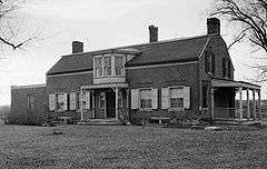
 Colonie Memorial Town Hall, Newtonville, NY | ||
|
||
| Official name: Town of Colonie | ||
| Name origin: From Dutch Colonie meaning a colony, referring to the Colony of Rensselaerswyck surrounding Albany | ||
| Country | United States | |
|---|---|---|
| State | New York | |
| Region | Capital District | |
| County | Albany | |
| River | Mohawk, Hudson | |
| Center | Colonie Town Hall | |
| - elevation | 344 ft (105 m) | |
| - coordinates | 42°43′10″N 73°45′22″W / 42.71944°N 73.75611°WCoordinates: 42°43′10″N 73°45′22″W / 42.71944°N 73.75611°W | |
| Highest point | Locust Lane Loudonville | |
| - elevation | 413 ft (126 m) | |
| - coordinates | 42°42′26″N 73°45′54″W / 42.70722°N 73.76500°W | |
| Lowest point | sea level | |
| - elevation | 0 ft (0 m) | |
| Area | 57.9 sq mi (150 km2) | |
| - land | 56.1 sq mi (145 km2) | |
| - water | 1.8 sq mi (5 km2) | |
| Population | 81,591 (2010) | |
| Density | 1,413.6/sq mi (546/km2) | |
| Incorporation as town | 1895 | |
| Government | ||
| - location | Town Hall | |
| Town supervisor | Paula A. Mahan (D) | |
| Timezone | EST (UTC-5) | |
| - summer (DST) | EDT (UTC-4) | |
| ZIP Code | 12047, 12110, 12189, 12204, 12205, 12211, 12241, 12303, 12304, 12309 | |
| Area code | 518 | |
| FIPS code | 36-17343[1] | |
| GNIS feature ID | 0978853[2] | |
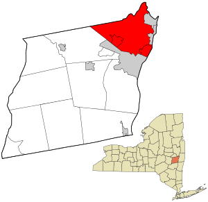 Location in Albany County and the state of New York.
| ||
| Wikimedia Commons: Colonie, New York | ||
| Website: www.colonie.org | ||

Colonie /ˌkɒləˈniː/ is a town in Albany County, New York, United States. It is the most populous suburb of Albany, New York, and is the third largest town in area in Albany County, occupying about 11% of the county. Several hamlets exist within the town. As of the 2010 census, the town had a total population of 81,591.
The name is derived from the Dutch Colonye or "Colonie", derived from the Colonie of Rensselaerswyck. All the land outside the Village of Beverwyck (now Albany) was referred to as the "Colonie". The town of Colonie is north of Albany and is at the northern border of the county. Within the town of Colonie are two villages, one also known as Colonie and the other known as Menands.
History

This area was once part of the Rensselaerwyck manor. The town of Colonie was formed in 1895 after the rural residents of the town of Watervliet opposed the state's proposal to transform the entire town into a city of Watervliet. The town/village of Green Island was also split off as a town from the town of Watervliet a year later and the village of West Troy that remained became the current city of Watervliet. All debts from the original town were divided proportionally between Green Island, Watervliet, and Colonie. Several lawsuits worked their way through the court system from the results of division.[3] The original town of Watervliet was the "mother of towns" in Albany County, having once been all the land outside of the city of Albany within the county,[4] all current towns either were formed directly or indirectly from a town formed from Watervliet. The central part of the town was once the location of the extensive Shaker community farms. The Watervliet Shaker Historic District is located in Colonie. Much of that land is now occupied by the Albany International Airport.
Through to the 1930s, Colonie was a simple series of extensive farms and a few hamlets. However, in the post-war years, there was intensive suburban development, originally on the corridor that connected Albany and Schenectady, but quickly throughout the entire township. By 1980, suburban development had saturated the community. At the same time, there were large highways (I-87, I-787, US Rt. 9 and NY Rt. 7) constructed which drastically changed the nature of the town and life there. The Colonie of the 1990s and beyond has become an entirely different community from the town of the 1930s and 1940s.
The Casparus F. Pruyn House at Newtonville is open to the public as the historical and cultural arts center for the Town of Colonie.
Historic sites
A number of sites in Colonie are included on the U.S. National Register of Historic Places,[5] including -
- Albany Rural Cemetery
- Bacon-Stickney House
- Senator William T. Byrne House
- Frederick Cramer House
- Martin Dunsbach House
- Royal K. Fuller House
- Goodrich School
- Isaac M. Haswell House
- Hedge Lawn
- Henry-Remsen House
- Ebenezer Hills, Jr., Farmhouse
- Friend Humphrey House
- John Wolf Kemp House
- John V. A. Lansing Farmhouse and Billsen Cemetery and Archeological Site
- George H. Lawton House
- Louis Menand House
- Menands Manor
- Reformed Dutch Church of Rensselaer in Watervliet
- Alfred H. Renshaw House
- Simmons Stone House
- Jedediah Strong House
- Treemont Manor
- George Trimble House
- Van Denbergh-Simmons House
- Watervliet Shaker Historic District
Geography
According to the United States Census Bureau, the town has a total area of 57.9 square miles (149.9 km²). 56.1 square miles (145.2 km²) of it is land and 1.8 square miles (4.7 km²) of it (3.11%) is water.
The north town line borders Schenectady County, and Saratoga County, marked by the Mohawk River. The east town line is the border of Rensselaer County, marked by the Hudson River. The town lies near the junction of the Hudson and the Mohawk.
Interstate 87, Interstate 787, and U.S. Route 9 pass through the town. State Routes 2, 5, 7, 32 and 155 are also important arterials within the town.
Location
 |
Schenectady County Town of Niskayuna City of Schenectady Town of Rotterdam |
Mohawk River/Saratoga County Towns of Clifton Park, Halfmoon, Waterford |
City of Cohoes | |
| Town of Guilderland | |
Town of Green Island City of Watervliet | ||
| ||||
| | ||||
| Town of Guilderland | City of Albany | Hudson River/ Rensselaer County City of Troy Town of North Greenbush |
Demographics
| Colonie Historical Populations | ||
|---|---|---|
| Year | Pop. | ±% |
| 1810 | 1,406 | — |
| 1900 | 7,035 | +400.4% |
| 1910 | 8,385 | +19.2% |
| 1920 | 10,196 | +21.6% |
| 1930 | 17,436 | +71.0% |
| 1940 | 20,631 | +18.3% |
| 1950 | 29,522 | +43.1% |
| 1960 | 52,760 | +78.7% |
| 1970 | 69,147 | +31.1% |
| 1980 | 74,593 | +7.9% |
| 1990 | 76,497 | +2.6% |
| 2000 | 79,258 | +3.6% |
| 2010 | 81,591 | +2.9% |
| 2014 | 83,015 | +1.7% |
| Sources: Source: | ||
As of the census[1] of 2000, there were 79,258 people, 30,980 households, and 20,539 families residing in the town. The population density was 1,413.6 inhabitants per square mile (545.8/km²). There were 32,280 housing units at an average density of 575.7 per square mile (222.3/km²). The racial makeup of the town was 90.55% White, 3.96% Black or African American, 0.15% Native American, 3.59% Asian, 0.02% Pacific Islander, 0.61% from other races, and 1.13% from two or more races. Hispanic or Latino of any race were 1.86% of the population.
There were 30,980 households out of which 29.2% had children under the age of 18 living with them, 53.3% were married couples living together, 9.6% had a female householder with no husband present, and 33.7% were non-families. 28.1% of all households were made up of individuals and 11.1% had someone living alone who was 65 years of age or older. The average household size was 2.43 and the average family size was 3.00.
In the town the population was spread out with 21.8% under the age of 18, 8.9% from 18 to 24, 27.8% from 25 to 44, 25.1% from 45 to 64, and 16.3% who were 65 years of age or older. The median age was 40 years. For every 100 females there were 92.8 males. For every 100 females age 18 and over, there were 89.6 males.
The median income for a household in the town was $51,817, and the median income for a family was $62,649. Males had a median income of $41,453 versus $30,763 for females. The per capita income for the town was $25,231. About 3.0% of families and 4.7% of the population were below the poverty line, including 4.5% of those under age 18 and 6.0% of those age 65 or over.
Politics
The current town supervisor is Paula Mahan, a Democrat. She was elected to her first term in November 2007, defeating long-time Republican incumbent Mary Brizzell. In November 2009, Mahan was re-elected to a second term, defeating former Republican Albany County Executive/former New York State Senator Michael J. Hoblock. In November 2011, Mahan was re-elected to a third term, defeating former New York State Department of Environmental Conservation Commissioner and the former Director of the town's Planning and Economic Development Committee, Denise Sheehan, by less than 400 votes. She was re-elected in 2013 to a fourth term by defeating political newcomer Todd A. Drake. The town board has six members, with four-year terms; three members are elected every odd-numbered year.
The seat of Colonie's government is Colonie Memorial Town Hall, located on U.S Route Route 9 in Newtonville, near Siena College. The town courts, police department, and emergency medical services department are located at the Public Safety Building on Wolf Road near Albany International Airport.
Public safety
Law enforcement in the town is primarily provided by the Town of Colonie Police Department; within the village of Menands which occupies the southeastern corner of the town there is the Village of Menands Police Department as well. However, that law enforcement is supplemented by the New York State Police Troop G (the headquarters of which lies within the town of Colonie), and the Albany County Sheriff's Office which patrols the Albany International Airport and operates the Albany County Correctional Facilities (which also lie within the town of Colonie).
In November 2007, the town of Colonie was ranked the sixth safest place to live in a Morgan Quitno Publishing study of crime rates across the United States. By November 2009 CQ Press (formerly known as Morgan Quitno Publishing) ranked the town of Colonie with the lowest crime rate of all communities in the United States with a population of at least 75,000 residents. The town held the top spot again in 2010 and has since continuously ranked at the top 10 or better for having the lowest crime rate of all communities in the United States with a population of at least 75,000 residents.[7]
Emergency Medical Service (advanced, basic, and transport) in the town is primarily provided by the Town of Colonie Emergency Medical Services (EMS) Department. The EMS Department operates out of four ambulance stations scattered throughout the town of Colonie to facilitate the most rapid response. The EMS Department also serves as an integral part of any heavy or light technical rescue operations in the town. In 1999, the town of Colonie Emergency Medical Services Department was awarded the National Association of Emergency Medical Technicians' National Paramedic Service of the Year Award. The award is given to one service of high distinction that has demonstrated excellence, innovation and community service.
On May 4, 2010, the town of Colonie was awarded the 2010 International Association of Fire Chiefs' “Heartsafe Community” award for making significant advances in emergency cardiac care. There are two awards given each year, one for large communities (over 100,000 in population) and one for a small communities (under 100,000 in population). Colonie was tapped for the small community honor and Anchorage, Alaska was tapped for the large community honor. On August 28, 2010, the New York State EMS Council awarded the town of Colonie Emergency Medical Services Department the New York State "EMS Agency of the Year" award.
Firefighting service in the town is primarily provided by one of twelve (mostly volunteer) firefighting agencies and one paid fire brigade. (See also Administrative divisions of New York.)
- Five Fire Districts (Boght Community, Midway, Schuyler Heights, Verdoy, and West Albany).
- One Joint Fire District (Stanford Heights [Niskayuna & Colonie]).
- Four Fire Protection Districts (Fuller Road, Latham, Maplewood, and Shaker Road-Loudonville).
- Two Village Fire Departments (Colonie and Menands).
These agencies encompass seventeen fire stations, two small rescue boats (Boght & Verdoy), seven ladder trucks (Fuller Road, Latham, Menands, Midway, Schuyler Heights, Shaker Road-Loudonville, and Stanford Heights), one Hazardous Materials Specialty Rescue (West Albany), one Trench/Structural Collapse Specialty Rescue (Village of Colonie), one Confined Space Specialty Rescue (Latham), eight General/Light Rescue apparatus, numerous full-size pumpers, a small number of attack pumpers, and a small number of EMS First-Response vehicles.
- One Paid Fire Brigade[8]
The Albany International Airport Fire Brigade consists of a full-time paid crash/fire/rescue staff, three crash/rescue vehicles, a mini pumper, hazmat truck, foam re-supply truck, and a full-size pumper. However, the airport's fire units stay on Airport Authority property most of the time, and are housed in yet another fire station that is on the Airport Authority's property. Occasionally, the Airport Fire Brigade responds to mutual aid requests with the bordering Shaker Road-Loudonville Fire Department, as well as other fire agencies within the town of Colonie and Albany County.
- Also located in the town of Colonie is a New York sponsored Urban Search and Rescue (USAR) Team, New York Task Force 2 (NY-TF2). NY-TF2 (then known as the New York Regional Response Team-1 {NYRRT-1}) was the first USAR team on site immediately following the attacks on, and collapse of, the World Trade Center on September 11, 2001, owing to the fact that many members of NY-TF1 (based in New York City) were members of the FDNY that perished in the collapse. Those same members provided much of the initial training to NY-TF2.
Education
There are four public school districts that serve the town of Colonie, the South Colonie Central School District, North Colonie Central Schools, Watervliet City School District, and Menands Union Free School District. South Colonie (Colonie Central High School) serves much of the western part of the town, including West Albany, the village of Colonie, and a small part of the adjoining town of Niskayuna. North Colonie (Shaker High School) serves Latham and the smaller, suburban and rural hamlets to the north of Latham, as well as most of Loudonville and Newtonville. The Watervliet City School District (Watervliet High School) serves some students from Menands and the Schuyler Heights area. The Menands Union Free School District is a single building school district serving the village of Menands and educates students from kindergarten through eighth grade. Upon completion of eighth grade, Menands Union Free School District students choose from a list (developed by the Menands UFSD) of local high schools to attend. In 2008, a fifth public school district, the Maplewood-Colonie Common School District, merged with-and-into the North Colonie School District.
The town of Colonie is also home to the Christian Brothers Academy, as well as several private and/or religious elementary schools. Siena College is located in the hamlet of Loudonville. Bryant & Stratton College and ITT Technical Institute, both proprietary colleges, have campuses in the town of Colonie.
Media
There are two dedicated weekly newspapers for parts of the town, the Colonie Spotlight and Loudonville Spotlight. Also, Channel 17 on Time Warner Cable in the town is a Public-access television station devoted to town news, programming, and events. The studios are located inside the William K. Sanford town library on Albany Shaker road.
Although not entirely dedicated to the town of Colonie, the headquarters and distribution center for the Capital Region's major daily newspaper, Times Union (owned by the Hearst Corporation), lies within the town. The town was the site of the fourth season finale of Extreme Makeover: Home Edition in 2007.
Communities and locations
- Albany International Airport (ALB) -- An airport servicing Albany and the Capital District.
- Boght Corners—A hamlet in the northeast part of the town.
- Colonie—An incorporated village in the southern part of the town.
- Crescent Station—A hamlet at the northernmost point of the town.
- Karner—A hamlet southwest of the village of Colonie.
- Dunsbach Ferry—A hamlet in the northwest part of the town at the Mohawk River.
- Latham—A hamlet near the center of the town.
- Lisha Kill—A hamlet in the northwest section of town, on Central Ave/ NY Route 5.
- Loudonville—A suburban hamlet near the Albany city line.
- Mannsville—Part of the Schuyler Heights Fire District and Watervliet City School District.[9]
- Maplewood—A hamlet adjacent to Cohoes, Watervliet and Green Island.
- Maywood—A hamlet northwest of the Village of Colonie on Central Ave/ NY Route 5.
- Menands—An incorporated village in the eastern part of the town.
- Newtonville—A hamlet between Latham and Loudonville.
- Schuyler Heights—A hamlet north of Menands; south and west of Watervliet; east of Loudonville; lying on the west bank of the Hudson River. Part of the Schuyler Heights Fire District[10] and Watervliet City School District and North Colonie School District.
- Roessleville—A suburban community near the city line of Albany.
- Shakers—A settlement southwest of Albany International Airport.
- Stanford Heights—A hamlet on the western edge of town, along the Schenectady County line.
- Verdoy—A hamlet north of Albany International Airport.
- West Albany—A hamlet on the southern edge of the town, along the Albany city line.
References
- 1 2 "American FactFinder". United States Census Bureau. Archived from the original on 2013-09-11. Retrieved 2008-01-31.
- ↑ "US Board on Geographic Names". United States Geological Survey. 2007-10-25. Retrieved 2008-01-31.
- ↑ National Reporter System (1898). New York Supplement, Vol. 50. W.C. Little & Co. pp. 488–491. Retrieved 2009-04-05.
- ↑ "New York State Museum Bulletin". New York State Museum. 1934: 21, 31.
- ↑ National Park Service (2010-07-09). "National Register Information System". National Register of Historic Places. National Park Service.
- ↑ "Census of Population and Housing". Census.gov. Archived from the original on May 11, 2015. Retrieved June 4, 2015.
- ↑ http://os.cqpress.com/citycrime/2013/cc2014.htm
- ↑ Albany International Airport Fire Brigade
- ↑ Mannsville, Albany County, New York profile, vliet.neric.org; accessed December 7, 2014.
- ↑ Schuyler Heights Fire District info, schuylerheightsvfd.com; accessed December 7, 2014.
External links
| Wikimedia Commons has media related to Colonie, New York. |
- Town of Colonie, New York, webpage
- Early history of Colonie region
- Village of Colonie, New York, webpage
Municipalities and communities of Albany County, New York, United States | ||
|---|---|---|
| Cities |  | |
| Towns | ||
| Villages | ||
| CDPs | ||
| Other hamlets |
| |