Adams, Massachusetts
| Adams, Massachusetts | ||
|---|---|---|
| Town | ||
|
| ||
| ||
 Location in Berkshire County and the state of Massachusetts. | ||
| Coordinates: 42°37′27″N 73°07′05″W / 42.62417°N 73.11806°WCoordinates: 42°37′27″N 73°07′05″W / 42.62417°N 73.11806°W | ||
| Country | United States | |
| State | Massachusetts | |
| County | Berkshire | |
| Settled | 1762 | |
| Incorporated | 1778 | |
| Government | ||
| • Type | Board of Selectmen Representative town meeting | |
| Area | ||
| • Total | 23.0 sq mi (59.5 km2) | |
| • Land | 22.9 sq mi (59.3 km2) | |
| • Water | 0.08 sq mi (0.2 km2) | |
| Elevation | 799 ft (244 m) | |
| Population (2010) | ||
| • Total | 8,485 | |
| • Density | 371/sq mi (143.1/km2) | |
| Time zone | Eastern (UTC-5) | |
| • Summer (DST) | Eastern (UTC-4) | |
| ZIP code | 01220 | |
| Area code(s) | 413 | |
| FIPS code | 25-00555 | |
| GNIS feature ID | 0619415 | |
| Website |
town | |


Adams is a town in northern Berkshire County, Massachusetts, United States. It is part of the Pittsfield, Massachusetts Metropolitan Statistical Area. The population was 8,485 at the 2010 census.[1]
History


Nathan Jones purchased the township of East Hoosac at auction in 1762 from the state for £3,200. In 1778, the town was officially incorporated as Adams, named in honor of Samuel Adams, a revolutionary leader and signer of the Declaration of Independence. Much of the land had been subdivided into 100-acre (0.40 km2) and 200-acre (0.81 km2) lots. These were mostly farms with frontage on the Hoosic River, which over time would provide water power for woolen, cotton, lumber, and plastic mills.
First settled in 1745, North Adams was originally part of Adams until the town split in 1878. Although there has never been a town of South Adams, the name was used prior to 1878 to specify the southern part of the town that had long had two primary centers, and survives in the name of the South Adams Savings Bank, which was incorporated in 1869.
Early settlers in the 1760s included a group of Quakers, many of whom came together from Smithfield, Rhode Island. The Quaker civil rights leader, abolitionist, and suffragist Susan B. Anthony was born in Adams, and her childhood home is today a museum.
The town's population declined from 1810 to 1820 as farmers moved west for better soil. But the War of 1812 allowed the textile industry to gain a foothold in the United States because British textiles were no longer available. In 1814, the Adams South Village Cotton Manufacture Company opened. With the establishment of a number of mills on the Hoosic River, Adams' population more than doubled to 4,000 between 1820 and 1835. Growth in both halves of Adams was further propelled by the opening of the Hoosac Tunnel in 1875. In the late 1800s, during the expansion of the cotton mills, the downtown was further urbanised by the construction of four large brick buildings on Park Street - P. J. Barrett Block, Jones Block, Armory Block, and the Mausert Block, opposite the Town Hall.
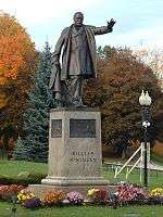
President William McKinley made two visits to the town, the second in 1897 to lay the cornerstone of the Adams Free Library. He was a friend of the Plunkett brothers (founders in 1889 of the Berkshire Cotton Manufacturing Company), and of the textile industry generally. In 1903, the assassinated president was honored with a larger-than-life statue beside the library. Berkshire Cotton later became a major part of Berkshire Hathaway, whose large factory in Adams was closed in 1958 (the 1,000 lost jobs were not the fault of Warren Buffett, who did not take over the firm until 1965). The mill town's only major remaining mill, Specialty Minerals, mines and processes limestone for calcium carbonate, used in antacids and food supplements, as well as paper whiteners and other industrial purposes.
The town's more recent move toward tourism, part of a broader trend in the Berkshires, is primarily centered on its natural beauty and outdoor activities, and on its proximity to the galleries, museums and colleges of North Adams.
Geography

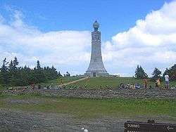
According to the United States Census Bureau, the town has a total area of 23.0 square miles (59.5 km2), of which 22.9 square miles (59.3 km2) is land and 0.077 square miles (0.2 km2), or 0.33%, is water.[1] The town lies along the valley surrounding the Hoosic River and its tributary brooks. Set between the Taconic Range to the west and the Hoosac Range of the Berkshires to the east, Adams includes the summit of Mount Greylock, elevation 3,491 feet (1,064 m) above sea level. The mountain, located within the state reservation of the same name, is the highest point in Massachusetts, a waypoint on the Appalachian Trail, and in the 19th-century inspired writers including Herman Melville. The town also includes a corner of Savoy Mountain State Park.
Adams is bordered to the north by North Adams, to the east by Florida and Savoy, to the south by Savoy and Cheshire, and to the west by New Ashford and Williamstown.
Massachusetts Route 8 is the primary north-south road through town, and was originally signed as New England Interstate Route 8, which extended southward to Bridgeport, Connecticut. The town is the northern terminus of Route 116, which extends southeast to Springfield.
Freight rail once ran through the town, but is now mostly converted to the paved Ashuwillticook Rail Trail. The town lies along the northern route of the Berkshire Regional Transit Authority. Regional bus service can be found in North Adams, as can regional air service at Harriman-and-West Airport. The nearest airport with international flights is Albany International Airport in New York.
Demographics
| Historical population | ||
|---|---|---|
| Year | Pop. | ±% |
| 1850 | 6,172 | — |
| 1860 | 6,924 | +12.2% |
| 1870 | 12,090 | +74.6% |
| 1880 | 5,591 | −53.8% |
| 1890 | 9,213 | +64.8% |
| 1900 | 11,134 | +20.9% |
| 1910 | 13,026 | +17.0% |
| 1920 | 12,967 | −0.5% |
| 1930 | 12,697 | −2.1% |
| 1940 | 12,608 | −0.7% |
| 1950 | 12,034 | −4.6% |
| 1960 | 12,391 | +3.0% |
| 1970 | 11,772 | −5.0% |
| 1980 | 10,381 | −11.8% |
| 1990 | 9,445 | −9.0% |
| 2000 | 8,809 | −6.7% |
| 2010 | 8,485 | −3.7% |
| * = population estimate. Source: United States Census records and Population Estimates Program data.[2][3][4][5][6][7][8][9][10][11] | ||
See also: Adams (CDP), Massachusetts

As of the census[12] of 2000, there were 8,809 people, 3,992 households, and 2,431 families residing in the town. Adams is the third most populated town in Berkshire County, and ranks 184th out of the 351 cities and towns in Massachusetts. The population density was 384.1 people per square mile (148.3/km²), ranking it third in the county and 197th in the Commonwealth. There were 4,362 housing units at an average density of 190.2 per square mile (73.4/km²), albeit packed into a fairly small portion of lower-lying land. The racial makeup of the town was 98.02% White, 0.36% Black or African American, 0.08% Native American, 0.24% Asian, 0.05% Pacific Islander, 0.27% from other races, and 0.98% from two or more races. Hispanic or Latino of any race were 0.82% of the population.
There were 3,992 households out of which 26.9% had children under the age of 18 living with them, 45.0% were married couples living together, 11.9% had a female householder with no husband present, and 39.1% were non-families. 34.8% of all households were made up of individuals and 17.7% had someone living alone who was 65 years of age or older. The average household size was 2.20 and the average family size was 2.81.

In the town the population was spread out with 22.4% under the age of 18, 6.6% from 18 to 24, 26.9% from 25 to 44, 23.6% from 45 to 64, and 20.4% who were 65 years of age or older. The median age was 41 years. For every 100 females there were 89.2 males. For every 100 females age 18 and over, there were 85.0 males.
The median income for a household in the town was $32,161, and the median income for a family was $40,559. Males had a median income of $34,110 versus $23,556 for females. The per capita income for the town was $18,572. About 7.0% of families and 10.3% of the population were below the poverty line, including 12.7% of those under age 18 and 12.9% of those age 65 or over.
Government
Adams employs the representative town meeting form of government, and is led by a town administrator and a board of selectmen. The current selectmen are John Duval, Arthur Harrington, Richard Blanchard, Joseph Nowak and Jeffrey Snoonian. The town has its own services, including police, fire and public works. The nearest hospital, North Adams Regional Hospital, is located in neighboring North Adams.

The Adams Free Library was founded in 1897, and was established as a war memorial, with the cornerstone being laid by President McKinley himself. In fiscal year 2008, the town of Adams spent 2.18% ($261,939) of its budget on its public library—some $31 per person.[13][14]
On the state level, Adams is represented in the Massachusetts House of Representatives by the First Berkshire district, which covers northern Berkshire County, as well as portions of Franklin County. In the Massachusetts Senate, the town is represented by the Berkshire, Hampshire and Franklin district, which includes all of Berkshire County and western Hampshire and Franklin counties.[15] The town is patrolled by the Fourth (Cheshire) Station of Barracks "B" of the Massachusetts State Police.[16]
On the national level, Adams is represented in the United States House of Representatives as part of Massachusetts's 1st congressional district, and has been represented by Richard Neal of Springfield since January 2013. Massachusetts is currently represented in the United States Senate by senior Senator Elizabeth Warren and junior Senator Ed Markey.
Education
Adams is joined with neighboring Cheshire to form a regional school district.[17] Each town runs its own elementary school, with Adams operating the C.T. Plunkett Elementary School, serving students from pre-kindergarten through fifth grade. Both towns send students to Hoosac Valley Middle and High School, just over the border in Cheshire. Hoosac Valley's colors are red and white, and their teams are nicknamed the "Hurricanes."
Adams is also home to the Berkshire Arts & Technology Charter Public School (BArT)[18] serving grades six through twelve. BArT is a free public school open to all students, that prepares students for college by promoting mastery of academic skills and content through the integration of the arts and technology in core subjects. The school provides middle and high school students in northern Berkshire County with an educational community that regards everyone, including teachers and parents, as lifelong learners.
High school students may choose to attend the public Charles H. McCann Technical High School in North Adams. There is also a parochial school in Adams, Saint Stanislaus Kostka, which serves students from pre-kindergarten through eighth grade, and other private schools are located in neighboring towns.
The nearest community college is Berkshire Community College in Pittsfield. The nearest state college is Massachusetts College of Liberal Arts in North Adams, and the nearest university is University of Massachusetts Amherst. The nearest private college is Williams College in nearby Williamstown.
Events and activities
- The Berkshire Visitors Bureau, at 3 Hoosac Street, offers maps, pamphlets and personal help to visitors throughout the region.
- The Quaker Meeting House, dating from 1782, is open Sundays from Memorial Day to Labor Day.
- Adams celebrates Susan B. Anthony with a festival in late July.
- The Adams Agricultural Fair is held in early August.
- The Fall Run Weekend and Motorcycle Ride, which benefits the Shriners Children's Hospital in Springfield, is held each September.
- The Mount Greylock Ramble attracts crowds of hikers to the summit each Columbus Day; this is also generally the end of the season for driving to the summit, and for using the Massachusetts Veterans Memorial tower and Bascom Lodge at the summit.
- RambleFest is a free event in downtown Adams, celebrating fall in the Berkshires during Columbus Day weekend. Live music, local food, craft beer and historic tours of Adams via a horse drawn trolley draws thousands to the Adams Visitor Center. RambleFest Details on ExploreAdams.com
- The Western Mass Athletic Club runs numerous road, trail and snowshoe races along Adams streets and at the Greylock Glen area at the foot of Mount Greylock.
- ThunderFest includes the Thunderbolt Ski Race followed by a celebration of winter recreation in downtown Adams. The Thunderbolt Ski Run is a back country ski race on the precipitous slope of Mount Greylock. Racers must get to the top of the state's highest peak under their own power, then ski or snowboard down the historic Class A Thunderbolt trail. Originally cut in the 1930s by the Civilian Conservation Corp, the Thunderbolt is a steep and challenging trail. ThunderFest is held outdoors at the Adams Visitors Center and features live music, local food and craft beer. Details available on ExploreAdams.com
Sites of interest
- Adams Agricultural Fair
- Ashuwillticook Rail Trail
- Mount Greylock State Reservation
- Pittsfield & North Adams Passenger Station and Baggage & Express House
- Quaker Meeting House (1782)
- St. Stanislaus Parish Roman Catholic Church
- Susan B. Anthony Birthplace & Museum
Notable people
- Daniel Read Anthony (1824–1904), publisher and militant abolitionist
- Susan B. Anthony (1820–1906), women's suffragist
- George N. Briggs (1796–1861), Governor of Massachusetts
- Lona Cohen (1913–1992) Soviet spy
- George P. Lawrence (1859–1917), US congressman
- Dale Long (1926–1991) Major League Baseball player
- Albert L. Phillips (born 1824), Wisconsin politician
- Stacy Schiff (born 1961), author
See also
References
- 1 2 "Geographic Identifiers: 2010 Demographic Profile Data (G001): Adams town, Berkshire County, Massachusetts". U.S. Census Bureau, American Factfinder. Retrieved December 18, 2013.
- ↑ "TOTAL POPULATION (P1), 2010 Census Summary File 1". American FactFinder, All County Subdivisions within Massachusetts. United States Census Bureau. 2010.
- ↑ "Massachusetts by Place and County Subdivision - GCT-T1. Population Estimates". United States Census Bureau. Retrieved July 12, 2011.
- ↑ "1990 Census of Population, General Population Characteristics: Massachusetts" (PDF). US Census Bureau. December 1990. Table 76: General Characteristics of Persons, Households, and Families: 1990. 1990 CP-1-23. Retrieved July 12, 2011.
- ↑ "1980 Census of the Population, Number of Inhabitants: Massachusetts" (PDF). US Census Bureau. December 1981. Table 4. Populations of County Subdivisions: 1960 to 1980. PC80-1-A23. Retrieved July 12, 2011.
- ↑ "1950 Census of Population" (PDF). Bureau of the Census. 1952. Section 6, Pages 21-10 and 21-11, Massachusetts Table 6. Population of Counties by Minor Civil Divisions: 1930 to 1950. Retrieved July 12, 2011.
- ↑ "1920 Census of Population" (PDF). Bureau of the Census. Number of Inhabitants, by Counties and Minor Civil Divisions. Pages 21-5 through 21-7. Massachusetts Table 2. Population of Counties by Minor Civil Divisions: 1920, 1910, and 1920. Retrieved July 12, 2011.
- ↑ "1890 Census of the Population" (PDF). Department of the Interior, Census Office. Pages 179 through 182. Massachusetts Table 5. Population of States and Territories by Minor Civil Divisions: 1880 and 1890. Retrieved July 12, 2011.
- ↑ "1870 Census of the Population" (PDF). Department of the Interior, Census Office. 1872. Pages 217 through 220. Table IX. Population of Minor Civil Divisions, &c. Massachusetts. Retrieved July 12, 2011.
- ↑ "1860 Census" (PDF). Department of the Interior, Census Office. 1864. Pages 220 through 226. State of Massachusetts Table No. 3. Populations of Cities, Towns, &c. Retrieved July 12, 2011.
- ↑ "1850 Census" (PDF). Department of the Interior, Census Office. 1854. Pages 338 through 393. Populations of Cities, Towns, &c. Retrieved July 12, 2011.
- ↑ "American FactFinder". United States Census Bureau. Archived from the original on 2013-09-11. Retrieved 2008-01-31.
- ↑ July 1, 2007 through June 30, 2008; cf. The FY2008 Municipal Pie: What’s Your Share? Commonwealth of Massachusetts, Board of Library Commissioners. Boston: 2009. Available: Municipal Pie Reports. Retrieved 2010-08-04
- ↑ http://town.adams.ma.us/Public_Documents/AdamsMA_Library/index Retrieved 2010-11-08
- ↑ Senators and Representatives by City and Town
- ↑ Station B-4, SP Cheshire
- ↑ acrsd.net
- ↑ bartcharter.org
External links
| Wikivoyage has a travel guide for Adams (Massachusetts). |
| Wikimedia Commons has media related to Adams, Massachusetts. |
| Wikisource has the text of the 1911 Encyclopædia Britannica article Adams. |
- Town of Adams official website
- Explore Adams
- Berkshire Visitors Bureau
- History of Adams, Massachusetts (1885)
-
 "Adams". Collier's New Encyclopedia. 1921.
 - "Adams". New International Encyclopedia. 1905.
Municipalities and communities of Berkshire County, Massachusetts, United States | ||
|---|---|---|
| Cities | 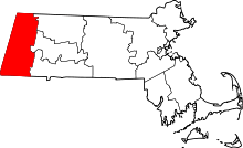 | |
| Towns | ||
| CDPs | ||
| Other villages | ||