Ravendale, California
| Ravendale | |
|---|---|
| Unincorporated community | |
 Ravendale  Ravendale Location in California | |
| Coordinates: 40°47′55″N 120°21′55″W / 40.79861°N 120.36528°WCoordinates: 40°47′55″N 120°21′55″W / 40.79861°N 120.36528°W | |
| Country | United States |
| State | California |
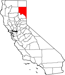
| County | Lassen County |
| Elevation[1] | 5,305 ft (1,617 m) |
Ravendale is an unincorporated community in Lassen County, California.[1] It is located 7 miles (11 km) southeast of Termo,[2] at an elevation of 5305 feet (1617 m).[1] According to Rand McNally, it is 54 driving miles to the county seat, Susanville, the only city in the county, and about the same distance to Alturas.
The Ravendale US post office opened in 1910, closed in 1920, and re-opened in 1921.[2] The ZIP Code is 96123.
Wired telephones in this area have telephone numbers following the pattern, (530) 234-xxxx. There is some cellular telephone coverage from unknown providers. The availability of PCS and Nextel coverage is undetermined.
There is a Ravendale Airport with the FAA identifier O39.
Susanville District, Ravendale Resource Area, Bureau of Land Management operates a fire station here. The fire station transmitter call sign is KMC407. There is also a Ravendale Volunteer Fire Department.[3]
Politics
In the state legislature, Ravendale is in the 1st Senate District, represented by Republican Ted Gaines, and in the 3rd Assembly District, represented by Republican Brian Dahle.
Federally, Ravendale is in California's 1st congressional district, represented by Republican Doug LaMalfa.[4]
The town mayor is Joseph Johnson, originally from Susanville, CA
References
- 1 2 3 U.S. Geological Survey Geographic Names Information System: Ravendale, California
- 1 2 Durham, David L. (1998). California's Geographic Names: A Gazetteer of Historic and Modern Names of the State. Clovis, Calif.: Word Dancer Press. p. 411. ISBN 1-884995-14-4.
- ↑ California Department of Forestry, Lassen-Modoc Ranger Unit 2005 annual report
- ↑ "California's 1st Congressional District - Representatives & District Map". Civic Impulse, LLC. Retrieved March 3, 2013.