Mapes, California
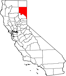
Mapes is a former settlement in Lassen County, California.[1] It was located on the Southern Pacific Railroad 2.5 miles (4 km) east-southeast of Litchfield.[1]
Mapes was settled by George Lathrop and Thomas J. Harvey in June (or possibly earlier) of 1859 and then known as the Lathrop place and then the Shaffer place.[2]
Shaffer Station[3] was on the Nobles Emigrant Trail.[4]
References
- 1 2 Durham, David L. (1998). California's Geographic Names: A Gazetteer of Historic and Modern Names of the State. Clovis, Calif.: Word Dancer Press. p. 393. ISBN 1-884995-14-4.
- ↑ Fairfield, Asa Merrill (1916). Fairfield's Pioneer History of Lassen County, California. H. S. Crocker. p. 150. Archived from the original on 2008-06-30. Retrieved 2013-12-31.
In June George Lathrop and Thos J Harvey located two sections of land running east and west on the lower end of Susan river but they may have been on the land before this. They built their cabin on the slough farthest to the north and at the place where the emigrant road from the Humboldt river first came near it. At first known as the Lathrop place and afterwards as the Shaffer place, it was for ten or twelve years a noted station on this road. Since then it has been owned by French and Litch Kelley and Winchel and now 1915 it is known as the Mapes place.
- ↑ Davis, William Newell (1974). Sagebrush Corner: The Opening of California's Northeast, Volume 5. Garland Pub. Incorporated. ISBN 9780824007751.
The place know as Shaffer's, three miles east of present Litchfield, began to develop in 1859 when George W. Lathrop and Thomas J. Harvey...
- ↑ "Nobles Trail". Emigrant Trails West. Retrieved 2013-12-31.
Shaffer Station (site) at Marker N-23
This article is issued from Wikipedia - version of the 10/23/2016. The text is available under the Creative Commons Attribution/Share Alike but additional terms may apply for the media files.