Port Sanilac Light
 Port Sanilac Lighthouse | |
 | |
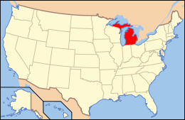
| Location | Port Sanilac, Michigan |
|---|---|
| Coordinates | 43°25′44″N 82°32′24″W / 43.42889°N 82.54000°WCoordinates: 43°25′44″N 82°32′24″W / 43.42889°N 82.54000°W |
| Year first lit | 1886[1] |
| Automated | 1928 |
| Foundation | dressed stone masonry/timber[2] |
| Construction | Brick |
| Tower shape | Octagonal hourglass[3] |
| Markings / pattern | White with red roof |
| Height | 59 feet (18 m)[4] |
| Focal height | 69 feet (21 m)[5] |
| Original lens | Fourth order Fresnel lens |
| Current lens | Fourth order Fresnel Lens[6] |
| Range | 16 nautical miles (30 km; 18 mi)[7] |
| Characteristic |
Fl (3) W 10s 1s fl 1s ec. 1s fl 1s ec. 1s fl 5s ec.[8] |
| ARLHS number | USA-651[9][10] |
| USCG number |
7-10115 |
|
Port Sanilac Light Station | |
| Location | Lake St., Port Sanilac, Michigan |
| Area | 0.3 acres (0.12 ha) |
| MPS | U.S. Coast Guard Lighthouses and Light Stations on the Great Lakes TR |
| NRHP Reference # | 84001842[11] |
| Added to NRHP | July 19, 1984 |
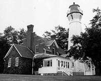
Port Sanilac Light is a United States Coast Guard lighthouse located on Point Sanilac, near Port Sanilac on the eastern side of Michigan's Thumb.[1] It is an automated and active aid to navigation on Lake Huron.[12][13]
History
Characterized by shallow water and sandbanks, the 75-mile (121 km) stretch of coastline between the Fort Gratiot Light and Pointe aux Barques Light is a hazard to navigation. Even after the establishment of the Sand Beach Harbor of Refuge Light in 1875, 30 miles (48 km) miles of coast line still remained completely unlit.[14]
Eighteen years after the first attempts to get congressional funding,[15] the station was established and first lit in 1886.[16] This Lake Huron lighthouse is 30 miles (48 km) north of the Fort Gratiot Lighthouse (Michigan's oldest) in Port Huron, Michigan.
The Port Sanilac Light's foundation consists of dressed stone and timber. The octagon-hourglass-shaped tower (near its top) is made of tiered and reverse stair-stepped brick. It is 14 feet (4.3 m) in diameter at its base, and tapers vertically to 9 feet (2.7 m) diameter below the gallery. Eschewing the usual corbels, a dozen courses of bricks create the gallery support, with four indentations for windows, creating a watch room for the four points of the compass.[14] The lighthouse was built at a cost of $20,000.[17] The placement and the unique shape were dictated by and created because of budgetary constraints (Congress appropriated only half the money requested). Designed by Eleventh District Engineer Captain Charles E. L. B. Davis, the design has been called "both unique and architecturally significant in its elegance."[14] The tower is white with a red roof.[2]
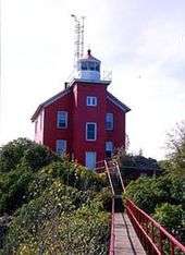
This "handsome" lighthouse shares its design with only one other, Ile Aux Galets, also known as Skilligallee Island Light, on Lake Michigan.[18]
The Port Sanilac Light tower is capped with a cast iron lantern room,[14] which still houses a fourth order Fresnel lens[16] manufactured by Barbier and Fenestre of Paris. The lens and its brass reflector on one segment (the reflector blocked the lens on the landward side) send the light out in a 300 degree arc across the lake. Its focal plane is 69 feet (21 m) shines a beam of light visible for up to 16 nautical miles (30 km; 18 mi) in all directions, thus closing most of the 30 miles (48 km)-gap mentioned above. The light sits atop high ground at the head of a small bay.[14] This is one of only 70 such Fresnel lenses that are still operational in the United States, sixteen of which are use on the Great Lakes of which eight are in Michigan.[19]
Port Sanilac Light Station — Lake St. is a registered site on the National Register of Historic Places, being added on August 19, 1984 as listed site #84001842. Name of Listing: PORT SANILAC LIGHT STATION (U.S. COAST GUARD/GREAT LAKES TR).[2]
The Port Sanilac Light complex currently consists of five historic structures. In addition to the light tower and ornate brick Lighthouse keeper's residence,[14] the brick oil house,[20] wooden outhouse, and well also survive. The well is covered by a safety platform of wooden planks.[17][21]
Because of its unique and picturesque form and location, it is often the subject of photographs, and even of needlepoint illustrations.[22] Drawings have also been produced,[23] as have postcards.[2]
The original fourth order Fresnel lens is still operative, being one of only 70 such lenses that remain operational in the United States; sixteen of them are use on the Great Lakes, of which eight are in Michigan.[6]
The lighthouse, including the keeper's house, is for sale.[24][25][26][27]
Getting there
The lighthouse is private property; access around it is prohibited. Viewing from the parking lot is very good. You can also walk down toward the beach and breakwater to get a good view of the lighthouse and harbor.
From ![]() M-25 in Port Sanilac, Michigan, turn east onto Cherry Street, taking it to the Lake Huron shore. Public parking is at the terminus of Cherry Street, directly south of the light. The breakwater "is a nice place from which the lighthouse can be photographed."[28][29]
M-25 in Port Sanilac, Michigan, turn east onto Cherry Street, taking it to the Lake Huron shore. Public parking is at the terminus of Cherry Street, directly south of the light. The breakwater "is a nice place from which the lighthouse can be photographed."[28][29]
See also
| Wikimedia Commons has media related to Port Sanilac Light Station. |
References
- 1 2 Michigan Lighthouse Fund, Port Sanilac.
- 1 2 3 4 Michigan Lighthouse Conservancy, Port Sanilac Lighthouse.
- ↑ Close up photograph of the hourglass stair-step brickwork at Terry Pepper, Seeing the Light.
- ↑ Pepper, Terry. "Database of Tower Heights". Seeing the Light. terrypepper.com.
- ↑ Pepper, Terry. "Database of Focal Heights". Seeing the Light. terrypepper.com.
- 1 2 United States Coast Guard, Fresnel Lenses Still in Operation.
- ↑ Light List, Volume VII, Great Lakes (PDF). Light List. United States Coast Guard. But see, 11 nautical miles; 21 kilometres (13 mi) at Seeing The Light - Port Sanilac Lighthouse
- ↑ Light List, Volume VII, Great Lakes (PDF). Light List. United States Coast Guard.
- ↑ Amateur Radio Lighthouse Society Port Sanilac (Lake Huron) Light, ARLHS USA-651.
- ↑ Amateur Radio Lighthouse Society, World List of Lights (WLOL).
- ↑ National Park Service (2009-03-13). "National Register Information System". National Register of Historic Places. National Park Service.
- ↑ Interactive map on Michigan lighthouses Detroit News.
- ↑ Port Sanilac Lighthouse, Pure Michigan.
- 1 2 3 4 5 6 Port Sanilac Lighthouse at Seeing the Light by Terry Pepper.
- ↑ Lighthouse Central, Port Sanilac Lighthouse Photographs, History and Directions, The Ultimate Guide to East Michigan Lighthouses by Jerry Roach (Publisher: Bugs Publishing LLC - July 2006). ISBN 0-9747977-1-5; ISBN 978-0-9747977-1-7.
- 1 2 "Historic Light Station Information and Photography: Michigan". United States Coast Guard Historian's Office.
- 1 2 Wobser, David, Boatnerd.com Port Sanilac Light.
- ↑ Rowlett, Russ. "Lighthouses of the United States: Michigan's Eastern Lower Peninsula". The Lighthouse Directory. University of North Carolina at Chapel Hill.
- ↑ United States Coast Guard, Fresnel Lenses Still in Operation
- ↑ Photo of the 360 US gallons (1,400 l; 300 imp gal) oil house at Terry Pepper, Seeing the Light.
- ↑ National Park Service, Maritime History Project, Inventory of Lights, Port Sanilac light.
- ↑ Needlepoint of Port Sanilac Light.
- ↑ Mulgrew, Marilyn, Drawing of Port Sanilac Light. {Dead link|date=September 2009}
- ↑ "Port Sanilac Lighthouse for sale". The Detroit News. December 15, 2013. Retrieved December 19, 2013. Photo gallery
- ↑ Fitzmorris, Ryan (December 18, 2013). "Iconic Port Sanilac Lighthouse can be yours for about $1 million". Detroit Free Press. Retrieved December 19, 2013. Photo gallery
- ↑ Weiss, Diane, photographer (December 18, 2013). "360 degree view of the Port Sanilac Lighthouse in Michigan" (Panoramic photo). Detroit Free Press. Retrieved December 19, 2013.
- ↑ Weiss, Diane, photographer (December 18, 2013). "360 degree view of the Port Sanilac Lighthouse in Michigan" (Panoramic photo). Detroit Free Press. Retrieved December 19, 2013. Same photo, pinned at Facebook
- ↑ Lighthouse Friends, Port Sanilac Lighthouse.
- ↑ U.S. Lighthouses, Port Sanilac Light.
External links
- "Aerial photos, Port Sanilac Light". marinas.com. Retrieved December 19, 2013.
- Interactive map of lighthouses in area.
- Interactive map, list, information for lighthouses in North and West Lake Huron.
- Michigan.gov website has a Map of Michigan Lighthouses.
- Port Sanilac Lighthouse at Seeing the Light by Terry Pepper.
- Satellite view at Google maps.
- "Port Sanilac Lighthouse for sale". The Detroit News. December 15, 2013. Retrieved December 19, 2013. Photo gallery
- Fitzmorris, Ryan (December 18, 2013). "Iconic Port Sanilac Lighthouse can be yours for about $1 million". Detroit Free Press. Retrieved December 19, 2013. Photo gallery
- Weiss, Diane, photographer (December 18, 2013). "360 degree view of the Port Sanilac Lighthouse in Michigan" (Panoramic photo). Detroit Free Press. Retrieved December 19, 2013. Same photo, pinned at Facebook
| Northern Upper Peninsula |
|  |
|---|---|---|
| Southern Upper Peninsula | ||
| St. Mary's River |
| |
| Portage River/Ship Canal |
| |
| Straits of Mackinac | ||
| Western Lower Peninsula |
| |
| Eastern Lower Peninsula |
| |
| Historical (lost) lights |
| |
| Related | ||
| Lists by county |
|   |
|---|---|---|
| Other lists |
| |