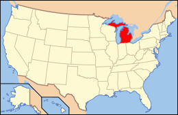
National Register of Historic Places listings in Kalamazoo County, Michigan
The following is a list of Registered Historic Places in Kalamazoo County, Michigan.
- This National Park Service list is complete through NPS recent listings posted December 16, 2016.[1]
| [2] | Name on the Register[3] | Image | Date listed[4] | Location | City or town | Description |
|---|---|---|---|---|---|---|
| 1 | The Acres | 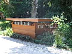 |
(#04000458) |
10036, 10069, 11090, 11108 and 11185 Hawthorne Dr. 42°15′42″N 85°24′32″W / 42.261667°N 85.408889°W |
Charleston Township | |
| 2 | Peter B. Appeldorn House | 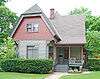 |
(#83000854) |
532 Village St. 42°16′59″N 85°35′30″W / 42.283056°N 85.591667°W |
Kalamazoo | |
| 3 | Booth-Dunham Estate | Upload image | (#98000271) |
6059 S. Ninth St. 42°13′45″N 85°40′33″W / 42.229167°N 85.675833°W |
Texas Charter Township | |
| 4 | Bronson Park Historic District | |
(#83000855) |
Roughly bounded by S. Rose, S. Park, W. Lovell, and W. Michigan Aves. 42°17′33″N 85°35′18″W / 42.2925°N 85.588333°W |
Kalamazoo | |
| 5 | Eric and Margaret Ann (Davis) Brown House | Upload image | (#16000200) |
2806 Taliesin Dr. 42°15′48″N 85°37′58″W / 42.263337°N 85.632707°W |
Kalamazoo | |
| 6 | Isaac Brown House | 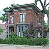 |
(#83000856) |
427 S. Burdick St. 42°17′17″N 85°34′58″W / 42.288056°N 85.582778°W |
Kalamazoo | |
| 7 | Climax Post Office Building | 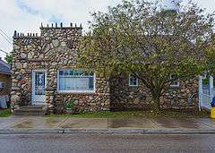 |
(#99000053) |
107 N. Main St. 42°14′19″N 85°20′10″W / 42.238611°N 85.336111°W |
Climax | |
| 8 | William S. Delano House | 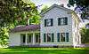 |
(#79001157) |
N of Kalamazoo at 555 W. E Ave. 42°21′39″N 85°35′55″W / 42.360833°N 85.598611°W |
Kalamazoo | |
| 9 | Desenberg Building | Upload image | (#79001158) |
251 E. Michigan Ave. 42°17′33″N 85°34′51″W / 42.2925°N 85.580833°W |
Kalamazoo | |
| 10 | Benjamin and Maria (Ogden) Drake Farm | 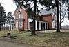 |
(#12001031) |
927 N. Drake Rd. 42°18′03″N 85°39′12″W / 42.30095°N 85.65323°W |
Kalamazoo | |
| 11 | East Hall | 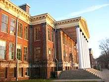 |
(#78001501) |
Oakland Dr. 42°17′10″N 85°35′47″W / 42.286111°N 85.596389°W |
Kalamazoo | |
| 12 | Engine House No. 3 | 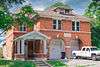 |
(#83000857) |
607 Charlotte Ave. 42°17′51″N 85°33′52″W / 42.2975°N 85.564444°W |
Kalamazoo | |
| 13 | Fanckboner-Nichols Farmstead | Upload image | (#07000387) |
5992 West VW Ave. 42°07′18″N 85°39′55″W / 42.121667°N 85.665278°W |
Prairie Ronde Township | |
| 14 | Fountain of the Pioneers | Upload image | (#16000417) |
Bronson Park, bounded by Academy, Rose, South & Park Sts. 42°17′25″N 85°35′08″W / 42.290191°N 85.585511°W |
Kalamazoo | |
| 15 | John Gibbs House | 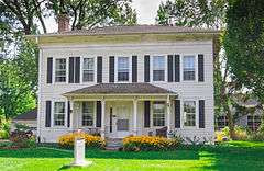 |
(#83000858) |
3403 Parkview Ave. 42°15′35″N 85°38′25″W / 42.259722°N 85.640278°W |
Kalamazoo | |
| 16 | Henry Gilbert House | 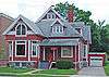 |
(#83000859) |
415 W. Lovell 42°17′19″N 85°35′16″W / 42.288611°N 85.587778°W |
Kalamazoo | |
| 17 | Richard and Mary Woodward Gregory House | Upload image | (#02000666) |
913 E. Augusta Rd. 42°20′35″N 85°20′38″W / 42.343056°N 85.343889°W |
Augusta | |
| 18 | Haymarket Historic District | 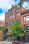 |
(#83000860) |
Michigan Ave. between Portage St. and the Grand Rapids and Indiana railroad line; also 105-141 E. Michigan Ave. 42°17′33″N 85°34′49″W / 42.2925°N 85.580278°W |
Kalamazoo | Second set of addresses represents a boundary increase of May 4, 2011 |
| 19 | Henderson Park-West Main Hill Historic District | Upload image | (#95000871) |
Roughly bounded by W. Main, Thompson, Academy, Monroe, W. Lovell and Valley Sts. and Prairie Ave. 42°17′29″N 85°36′21″W / 42.291389°N 85.605833°W |
Kalamazoo | |
| 20 | Illinois Envelope Co. Building | 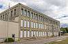 |
(#83000861) |
400 Bryant St. 42°16′19″N 85°34′40″W / 42.271944°N 85.577778°W |
Kalamazoo | |
| 21 | Kalamazoo State Hospital Water Tower | 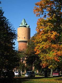 |
(#72000624) |
Oakland Dr. 42°16′37″N 85°36′28″W / 42.276944°N 85.607778°W |
Kalamazoo | |
| 22 | Silas W. Kendall House | Upload image | (#90001958) |
7540 Stadium Dr., Oshtemo Township 42°15′19″N 85°41′52″W / 42.255278°N 85.697778°W |
Kalamazoo | |
| 23 | Ladies Library Association Building |  |
(#70000274) |
333 S. Park St. 42°17′20″N 85°35′13″W / 42.288889°N 85.586944°W |
Kalamazoo | |
| 24 | Lawrence and Chapin Building |  |
(#83000862) |
201 N. Rose St. 42°17′34″N 85°35′07″W / 42.292778°N 85.585278°W |
Kalamazoo | |
| 25 | Lee Paper Company Mill Complex | Upload image | (#16000524) |
300 W. Highway St. 42°06′51″N 85°32′16″W / 42.114245°N 85.537814°W |
Vicksburg | |
| 26 | David Lilienfeld House | 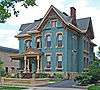 |
(#86000119) |
447 W. South St. 42°17′22″N 85°35′18″W / 42.289444°N 85.588333°W |
Kalamazoo | |
| 27 | The Marlborough | 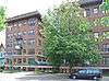 |
(#83000863) |
471 W. South St. 42°17′22″N 85°35′21″W / 42.289444°N 85.589167°W |
Kalamazoo | |
| 28 | Masonic Temple Building | 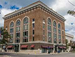 |
(#80001876) |
309 N. Rose St. 42°17′38″N 85°35′06″W / 42.293889°N 85.585°W |
Kalamazoo | |
| 29 | Michigan Central Depot |  |
(#75000949) |
459 N. Burdick St. 42°17′44″N 85°35′03″W / 42.295556°N 85.584167°W |
Kalamazoo | |
| 30 | Henry Montague House | 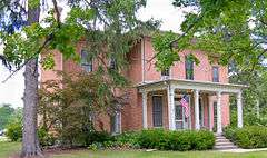 |
(#83000864) |
814 Oakland Dr. 42°17′01″N 85°35′55″W / 42.283611°N 85.598611°W |
Kalamazoo | |
| 31 | The Oaklands | Upload image | (#83000865) |
1815 W. Michigan Ave. 42°17′01″N 85°36′41″W / 42.283611°N 85.611389°W |
Kalamazoo | |
| 32 | Old Central High School | 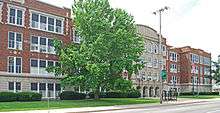 |
(#83000866) |
714 S. Westnedge Ave. 42°17′05″N 85°35′26″W / 42.284722°N 85.590556°W |
Kalamazoo | |
| 33 | Old Fire House No. 4 | 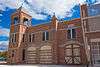 |
(#83000867) |
526 N. Burdick St. 42°17′50″N 85°34′59″W / 42.297222°N 85.583056°W |
Kalamazoo | |
| 34 | Oshtemo Town Hall | Upload image | (#04000459) |
10 S. Eighth St. 42°17′19″N 85°41′15″W / 42.288611°N 85.6875°W |
Oshtemo Charter Township | |
| 35 | Portage Street Fire Station | Upload image | (#85002150) |
1249 Portage St. 42°16′46″N 85°34′12″W / 42.279444°N 85.57°W |
Kalamazoo | |
| 36 | Alonzo T. Prentice House | Upload image | (#83000868) |
839 W. Lovell St. 42°17′19″N 85°35′42″W / 42.288611°N 85.595°W |
Kalamazoo | |
| 37 | Richland Historic District | Upload image | (#97000278) |
7567-8020 N. 32nd, 8023-8047 Church, 8951-8965 Park Sts., 8650-8118 E. D Ave., 8760-8905 Gull Rd., 9057-9063 RR 42°22′27″N 85°27′26″W / 42.374167°N 85.457222°W |
Richland | |
| 38 | Rickman Hotel | 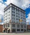 |
(#94001425) |
345 N. Burdick 42°17′39″N 85°35′01″W / 42.294167°N 85.583611°W |
Kalamazoo | |
| 39 | Martin W. Roberts House |  |
(#83000869) |
703 Wheaton Ave. 42°16′54″N 85°35′33″W / 42.281667°N 85.5925°W |
Kalamazoo | |
| 40 | Rose Place Historic District | 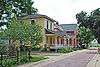 |
(#83000870) |
Rose Pl. 42°16′58″N 85°35′08″W / 42.282778°N 85.585556°W |
Kalamazoo | |
| 41 | Enoch Shaffer House | 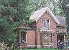 |
(#83000871) |
1437 Douglas Ave. 42°18′22″N 85°36′12″W / 42.306111°N 85.603333°W |
Kalamazoo | |
| 42 | Patrick and Sarah Dobbins Shields House | 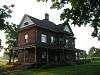 |
(#07000745) |
6681 N. 2nd St. 42°21′19″N 85°44′46″W / 42.355278°N 85.746111°W |
Alamo | |
| 43 | South Street Historic District | 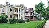 |
(#79001159) |
South St. between Oakland Dr. and Westnedge Ave.; also roughly W. Lovell St. from Oakland Dr. to Pearl St. and Academy St. east of Oakland 42°17′22″N 85°35′32″W / 42.289444°N 85.592222°W |
Kalamazoo | Second set of boundaries represents a boundary increase of April 14, 1995 |
| 44 | Sparks-Anderson House | Upload image | (#14000125) |
7653 W. Main St. 42°17′43″N 85°41′58″W / 42.295278°N 85.699444°W |
Oshtemo Township | |
| 45 | State Hospital Gatehouse | 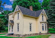 |
(#83000872) |
1006 Oakland Dr. 42°16′53″N 85°36′00″W / 42.281389°N 85.6°W |
Kalamazoo | |
| 46 | Andrew J. Stevens House | 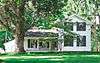 |
(#83000873) |
4024 Oakland Dr. 42°00′00″N 85°36′52″W / 42°N 85.614444°W |
Kalamazoo | |
| 47 | Stuart Area Historic District | Upload image | (#83000874) |
Roughly bounded by the Michigan Central railroad line, Douglas, Forbes, W. Main, North, and Elm Sts., and Kalamazoo and Grand Aves.; also roughly along Ransom and Willard Sts., Allen Boulevard and Eleanor St., and 425-433 Douglas St. and 818 North St. 42°17′40″N 85°35′54″W / 42.294444°N 85.598333°W |
Kalamazoo | Second set of boundaries represents a boundary increase of July 20, 1995 |
| 48 | Charles E. Stuart House | 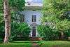 |
(#72000625) |
427 Stuart Ave. 42°17′43″N 85°35′53″W / 42.295278°N 85.598056°W |
Kalamazoo | |
| 49 | Dr. Nathan M. Thomas House | Upload image | (#82002843) |
613 E. Cass St. 42°06′59″N 85°37′47″W / 42.116389°N 85.629722°W |
Schoolcraft | |
| 50 | Vine Area Historic District | 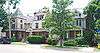 |
(#83000875) |
Roughly bounded by S. Rose, S. Westnedge, W. Walnut, and Ranney Sts. 42°17′05″N 85°35′12″W / 42.284722°N 85.586667°W |
Kalamazoo | |
| 51 | William L. Welsh Terrace | 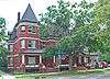 |
(#83000876) |
101-105 W. Dutton St. 42°17′05″N 85°35′00″W / 42.284722°N 85.583333°W |
Kalamazoo | |
| 52 | Western State Normal School Historic District | |
(#90001230) |
Roughly bounded by Stadium Dr., Oliver St., and Davis St. 42°17′08″N 85°35′58″W / 42.285556°N 85.599444°W |
Kalamazoo |
See also
| Wikimedia Commons has media related to National Register of Historic Places in Kalamazoo County, Michigan. |
- List of Registered Historic Places in Michigan
- List of Michigan State Historic Sites in Kalamazoo County, Michigan
References
- ↑ "National Register of Historic Places: Weekly List Actions". National Park Service, United States Department of the Interior. Retrieved on December 16, 2016.
- ↑ Numbers represent an ordering by significant words. Various colorings, defined here, differentiate National Historic Landmarks and historic districts from other NRHP buildings, structures, sites or objects.
- ↑ National Park Service (2008-04-24). "National Register Information System". National Register of Historic Places. National Park Service.
- ↑ The eight-digit number below each date is the number assigned to each location in the National Register Information System database, which can be viewed by clicking the number.
| Lists by county |
|   |
|---|---|---|
| Other lists |
| |
| Topics | |
|---|---|
| Lists by states |
|
| Lists by insular areas | |
| Lists by associated states | |
| Other areas | |
| |
This article is issued from Wikipedia - version of the 8/28/2016. The text is available under the Creative Commons Attribution/Share Alike but additional terms may apply for the media files.