National Register of Historic Places listings in St. Joseph County, Michigan
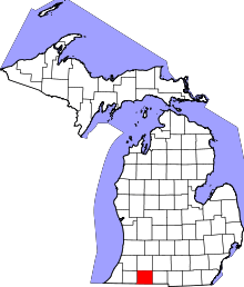
Location of St. Joseph County in Michigan
This is a list of the National Register of Historic Places listings in St. Joseph County, Michigan.
This is intended to be a complete list of the properties and districts on the National Register of Historic Places in St. Joseph County, Michigan, United States. Latitude and longitude coordinates are provided for many National Register properties and districts; these locations may be seen together in a map.[1]
There are 16 properties and districts listed on the National Register in the county.
- This National Park Service list is complete through NPS recent listings posted December 16, 2016.[2]
Current listings
| [3] |
Name on the Register[4] |
Image |
Date listed[5] |
Location |
City or town |
Description |
|---|
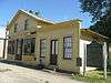
| 1 |
Art Gallery Building |
Upload image |
000000001980-05-09-0000May 9, 1980
(#80004070) |
156 S. Washington St.
41°50′29″N 85°40′08″W / 41.841389°N 85.668889°W / 41.841389; -85.668889 (Art Gallery Building) |
Constantine |
|
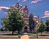
| 2 |
Gov. John S. Barry House |
|
000000001972-03-16-0000March 16, 1972
(#72001308) |
280 N. Washington St.
41°50′44″N 85°40′19″W / 41.845556°N 85.671944°W / 41.845556; -85.671944 (Gov. John S. Barry House) |
Constantine |
|
| 3 |
Leverett A. and Amanda (Hampson) Clapp House |
|
000000002009-07-01-0000July 1, 2009
(#09000476) |
324 W. Main St.
41°55′26″N 85°31′50″W / 41.923889°N 85.530485°W / 41.923889; -85.530485 (Leverett A. and Amanda (Hampson) Clapp House) |
Centreville |
|
| 4 |
Constantine Historic Commercial District |
Upload image |
000000001985-09-17-0000September 17, 1985
(#85002444) |
Washington St. between 2nd and Water, and Water St. between White Pigeon and 125 W. Water
41°50′31″N 85°40′08″W / 41.841944°N 85.668889°W / 41.841944; -85.668889 (Constantine Historic Commercial District) |
Constantine |
|
| 5 |
Downtown Three Rivers Commercial Historic District |
Upload image |
000000001982-04-29-0000April 29, 1982
(#82004472) |
N. Main St., Michigan and Portage Aves.
41°56′42″N 85°38′01″W / 41.945°N 85.633611°W / 41.945; -85.633611 (Downtown Three Rivers Commercial Historic District) |
Three Rivers |
|
| 6 |
Farrand Hall |
Upload image |
000000001972-08-25-0000August 25, 1972
(#72001307) |
451 Farrand Rd.
41°56′54″N 85°20′33″W / 41.948333°N 85.3425°W / 41.948333; -85.3425 (Farrand Hall) |
Colon |
|
| 7 |
M-86-Prairie River Bridge |
|
000000002000-02-04-0000February 4, 2000
(#00000044) |
M-86 over the Prairie River
41°55′08″N 85°28′54″W / 41.918889°N 85.481667°W / 41.918889; -85.481667 (M-86-Prairie River Bridge) |
Nottawa |
|
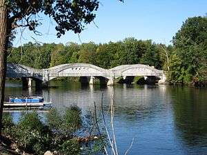
| 8 |
Marantette Bridge |
Upload image |
000000002001-06-25-0000June 25, 2001
(#01000708) |
Railroad St., Buckner Rd. over the St. Joseph River
41°59′56″N 85°27′30″W / 41.998889°N 85.458333°W / 41.998889; -85.458333 (Marantette Bridge) |
Mendon |
|
| 9 |
Marantette House |
Upload image |
000000001973-04-11-0000April 11, 1973
(#73001947) |
Simpson Rd.
42°00′00″N 85°27′19″W / 42.0°N 85.455278°W / 42.0; -85.455278 (Marantette House) |
Mendon |
|
| 10 |
Morse-Scoville House |
Upload image |
000000001996-07-25-0000July 25, 1996
(#96000801) |
685 S. Washington
41°50′13″N 85°39′53″W / 41.836944°N 85.664722°W / 41.836944; -85.664722 (Morse-Scoville House) |
Constantine |
|
| 11 |
Nottawa Stone School |
|
000000001972-01-13-0000January 13, 1972
(#72001309) |
East of Nottawa at the junction of Sturgis and Filmore Rds.
41°55′10″N 85°26′25″W / 41.919444°N 85.440278°W / 41.919444; -85.440278 (Nottawa Stone School) |
Nottawa |
|
| 12 |
Arthur Silliman House |
Upload image |
000000001979-11-20-0000November 20, 1979
(#79002662) |
116 S. Main St.
41°56′37″N 85°37′55″W / 41.943611°N 85.631944°W / 41.943611; -85.631944 (Arthur Silliman House) |
Three Rivers |
|
| 13 |
St. Joseph County Courthouse |
|
000000001993-09-16-0000September 16, 1993
(#93000984) |
125 W. Main St.
41°55′22″N 85°31′41″W / 41.922778°N 85.528056°W / 41.922778; -85.528056 (St. Joseph County Courthouse) |
Centreville |
|
| 14 |
US 12 St. Joseph River Bridge |
|
000000001991-04-05-0000April 5, 1991
(#91000388) |
U. S. Route 12 over the St. Joseph River, Mottville Township
41°48′00″N 85°45′25″W / 41.8°N 85.756944°W / 41.8; -85.756944 (US 12 St. Joseph River Bridge) |
Mottville |
|
| 15 |
Old US Government Land Office Building |
|
000000001989-02-07-0000February 7, 1989
(#88003234) |
113 W. Chicago Rd.
41°47′52″N 85°38′38″W / 41.797778°N 85.643889°W / 41.797778; -85.643889 (Old US Government Land Office Building) |
White Pigeon |
|
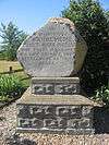
| 16 |
Wahbememe Burial Site and Monument |
|
000000001995-07-21-0000July 21, 1995
(#95000867) |
Junction of U.S. Routes 12 and 131, Mottville Township
41°47′51″N 85°39′47″W / 41.797500°N 85.663056°W / 41.797500; -85.663056 (Wahbememe Burial Site and Monument) |
White Pigeon |
|
See also
References
- ↑ The latitude and longitude information provided in this table was derived originally from the National Register Information System, which has been found to be fairly accurate for about 99% of listings. For about 1% of NRIS original coordinates, experience has shown that one or both coordinates are typos or otherwise extremely far off; some corrections may have been made. A more subtle problem causes many locations to be off by up to 150 yards, depending on location in the country: most NRIS coordinates were derived from tracing out latitude and longitudes off of USGS topographical quadrant maps created under the North American Datum of 1927, which differs from the current, highly accurate WGS84 GPS system used by most on-line maps. Chicago is about right, but NRIS longitudes in Washington are higher by about 4.5 seconds, and are lower by about 2.0 seconds in Maine. Latitudes differ by about 1.0 second in Florida. Some locations in this table may have been corrected to current GPS standards.
- ↑ "National Register of Historic Places: Weekly List Actions". National Park Service, United States Department of the Interior. Retrieved on December 16, 2016.
- ↑ Numbers represent an ordering by significant words. Various colorings, defined here, differentiate National Historic Landmarks and historic districts from other NRHP buildings, structures, sites or objects.
- ↑ National Park Service (2008-04-24). "National Register Information System". National Register of Historic Places. National Park Service.
- ↑ The eight-digit number below each date is the number assigned to each location in the National Register Information System database, which can be viewed by clicking the number.