Fourteen Foot Shoal Light
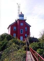
 The light in 2001 (note the solar panels that provide the current power) | |
 | |
| Location | Lake Huron, Michigan |
|---|---|
| Coordinates | 45°40′47.3″N 84°26′6″W / 45.679806°N 84.43500°WCoordinates: 45°40′47.3″N 84°26′6″W / 45.679806°N 84.43500°W |
| Year first constructed | 1929 |
| Year first lit | 1930 |
| Automated | 1930 |
| Foundation | Pneumatic/sub[1] |
| Construction | Reinforced concrete and steel |
| Tower shape | square building; frustum of a cone tower |
| Markings / pattern | White with red trim |
| Height | Tower – 36 feet (11 m)[2] |
| Focal height | Focal plane – 55 feet (17 m)[3][4] |
| Original lens | Fourth-order Fresnel lens[5] |
| Current lens | 9.8-inch (250 mm) Tidelands acrylic optic Fresnel lens |
| Range | 14 nautical miles (26 km; 16 mi)[6] |
| Characteristic |
0cculting W 4 seconds Operates year round. |
| Fog signal | HORN: 1 blast ev 15 s (2s bl)[6] Diaphone |
| ARLHS number | USA-306[7][8] |
| USCG number |
7-11765 |
|
Fourteen Foot Shoal Light Station | |
| NRHP Reference # | 05000742[9] |
| Added to NRHP | July 27, 2005 |
The lighthouse at Fourteen Foot Shoal was named to note that the lake is only 14 feet (4.3 m) deep at this point, which is a hazard to navigation, ships and mariners.
This light is located at the northern end of Lake Huron, Michigan, US, where it is necessary for boats heading to Chicago to pass through a narrow strait and still avoid shallow water. The most common path is to go south of Bois Blanc Island (Michigan). In this channel, the Poe Reef Light marks the northern end of the safe channel and the Fourteen Foot Shoal light marks the southern side of the channel.
History
The United States Lighthouse Service intended from the time of design that this light would be automated (possibly the first such instance) and operated by radio control[10] from the nearby Poe Reef Light which is 3.5 miles (5.6 km) away; the keeper's house was never intended to be used as a residence.[11] In 1925 a temporary acetylene buoy was installed there and construction of the permanent light began in 1929 such that the light could begin operation in 1930.[12]
The original light was a fourth-order Fresnel lens.[13] The focal plane is 56 feet (17 m). It now has a 9.8-inch (250 mm) acrylic optic Fresnel lens, and assuming it is properly installed and adjusted, has a maximum visible range of 9 nmi (17 km).[14] A diaphone fog horn is attached.[3]
Current status and getting there
It is in U.S. Coast Guard District 9, and is still an active aid to navigation.[15]
In 2002 the crew of the Cutter USCGC Mackinaw (WAGB-83) painted and refurbished the light.[16]
The light has been added to the National Register of Historic Places; but is not on the state registry, although it was determined to be eligible by the Michigan State Historic Preservation Office.[17]
A private boat is, of course, the best way to see this light close up. Short of that, Sheplers Ferry Service out of Mackinaw City offers periodic lighthouse cruises in the summer season. Its "Eastbound Tour" includes passes by Round Island Light, Bois Blanc Island and Light, Poe Reef Light and Fourteen Foot Shoal. Schedules and rates are available from Shepler's.[12][18] Boat narration is provided by the Great Lakes Lightkeepers Association.[19]
A distant view can be had from the Cheboygan Crib Light[20] and the Cheboygan State Park.[19]
On May 15, 2012, the National Park Service made the light available for ownership transfer under the National Historic Lighthouse Preservation Act.[21]
References
- ↑ "Historic Light Station Information and Photography: Michigan". United States Coast Guard Historian's Office.
- ↑ Terry Pepper, database on heights and focal planes.
- 1 2 National Park Service, Maritime Heritage Program, Inventory of Historic Lights, Fourteen Foot Shoal Light.
- ↑ Pepper, Terry. "Database of Focal Heights". Seeing the Light. terrypepper.com.
- ↑ Pepper, Terry. "Database of Original Lenses". Seeing the Light. terrypepper.com.
- ↑ "Amateur Radio Lighthouse Society, Fourteen Foot Shoal (Lake Huron) Light, ARLHS USA-306.".
- ↑ "Amateur Radio Lighthouse Society, World List of Lights (WLOL).".
- ↑ "National Register Information System". National Register of Historic Places. National Park Service. 2009-03-13.
- ↑ Fourteen Foot Shoal LIghthouse at U.S. lighthouses.com.
- ↑ Edin, Colt, and Wobser, David, Fourteen Foot Shoal Light at Boatnerd.com.
- 1 2 Terry Pepper, Seeing the Light, Fourteen Foot Shoal Light.
- ↑
- ↑ 250 mm acrylic optic lens, Terry Pepper, Seeing the Light.
- ↑ Michigan Lighthouse Conservancy, Fourteen Foot Shoal Light.
- ↑ Rowlett, Russ. "Lighthouses of the United States: Michigan's Eastern Lower Peninsula". The Lighthouse Directory. University of North Carolina at Chapel Hill.
- ↑ National Park Service, Maritime Heritage Project, Inventory of Historic Lights, Fourteen Foot Shoal Light.
- ↑ Sheplers Ferry Service.
- 1 2 West Michigan Tourist Association, Fourteen Foot Shoal Light.
- ↑ Anderson, Kraig. Lighthouse friends, 14 Foot Shoal Light.
- ↑ "NATIONAL HISTORIC LIGHTHOUSE PRESERVATION ACT NOTICE OF AVAILABILITY - Fourteen Foot Shoal Light" (PDF). U.S. National Park Service.
Further reading
- "A Tour of the Lights of the Straits." Michigan History 70 (Sep/Oct 1986), pp. 17–29.
- Lighthouse Central, Fourteen Foot Shoal light The Ultimate Guide to East Michigan Lighthouses by Jerry Roach (Publisher: Bugs Publishing LLC - July 2006). ISBN 0-9747977-1-5; ISBN 978-0-9747977-1-7.
External links

- Interactive map on Michigan lighthouses. Detroit News
- Interactive map, pictures, descriptions of Northern Lake Huron lights.
- Lighthouses in the Mackinac Straits.
- Terry Pepper, Seeing the Light, Fourteen Foot Shoal Light.
| Northern Upper Peninsula |
|  |
|---|---|---|
| Southern Upper Peninsula | ||
| St. Mary's River |
| |
| Portage River/Ship Canal |
| |
| Straits of Mackinac | ||
| Western Lower Peninsula |
| |
| Eastern Lower Peninsula |
| |
| Historical (lost) lights |
| |
| Related | ||
| Topics | |
|---|---|
| Lists by states |
|
| Lists by insular areas | |
| Lists by associated states | |
| Other areas | |
| |