Round Island Passage Light
 | |
 | |
| Location | Mackinac Island, Michigan |
|---|---|
| Coordinates | 45°50′36″N 84°36′54″W / 45.84333°N 84.61500°WCoordinates: 45°50′36″N 84°36′54″W / 45.84333°N 84.61500°W |
| Year first constructed | 1947 |
| Year first lit | 1948 |
| Automated | 1973 |
| Foundation | Crib |
| Construction | Reinforced concrete |
| Tower shape | Octagonal |
| Markings / pattern | White tower with red band |
| Focal height | 71 feet (22 m) |
| Original lens | Sealed beam |
| Current lens | 7.5-inch (190 mm) |
| Range | 14 nautical miles (26 km; 16 mi) |
| Characteristic | Flashing red 5s |
| Fog signal | Horn: On request - 1 every 30s |
| Racon | "X" (– • • –) |
| ARLHS number | USA-710 |
| USCG number | |
|
Round Island Passage Light | |
|
Round Island Passage Light is SW of the southern end of the west breakwater guarding Haldimand Bay. | |
| MPS | Light Stations of the United States MPS |
| NRHP Reference # | 13000583[4] |
| Added to NRHP | August 7, 2013[5] |
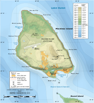
Round Island Passage Light is an automated, unmanned 1948 lighthouse located in the Round Island Channel in the Straits of Mackinac, Michigan. The channel is a branch of Lake Huron.[6]
History
Round Island Passage Light, built by the United States Coast Guard of concrete and steel in the period immediately following World War II, was one of the last lights to be constructed on the Great Lakes. The light was built at the same time that Round Island Light, an 1898 historically manned lighthouse at the other end of the channel, was deactivated. As of 2009, however, Round Island Light has been relighted as a private aid to navigation, and both lights currently mark the channel.[7]
On August 7, 2013, the light was listed on the National Register of Historic Places.[5]
See also
References
- ↑ Light List, Volume VII, Great Lakes (PDF). Light List. United States Coast Guard. 2009. p. 126.
- ↑ "Historic Light Station Information and Photography: Michigan". United States Coast Guard Historian's Office.
- ↑ Rowlett, Russ (2010-03-12). "Lighthouses of the United States: Michigan's Eastern Upper Peninsula". The Lighthouse Directory. University of North Carolina at Chapel Hill.
- ↑ National Park Service (March 13, 2009). "National Register Information System". National Register of Historic Places. National Park Service.
- 1 2 "Weekly List of Actions Taken on Properties: 8/05/13 Through 8/09/13". National Register of Historic Places. National Park Service. Retrieved August 17, 2013.
- ↑ "Chart 14881:Lake Huron: Straits of Mackinac: De Tour Pass to Waugoshance Point (1/80,000)". NOAA. 2005.
- ↑ "Chart 14881:Inset: Mackinac Island (1/10,000)". NOAA. 2005.
Further reading
- "A Tour of the Lights of the Straits." Michigan History 70 (Sep/Oct 1986), pp. 17–29.
- Brisson, Steven C. (Mackinac State Historic Parks chief curator). Old Mackinac Point Lighthouse: A History & Pictorial Souvenir (1/29/2008).
- "Round Island Passage Light Station." Proceedings of the Merchant Marine Council 5 (Sep 1948), p. 145.
- "Round Island Passage Light Station Established." Coast Guard Engineers Digest No. 51 (Jul-Aug, 1948), pp. 28–29; No. 52 (Sep-Oct 1948), pp. 10–12.
External links
- Interactive map of Lights in Northern Lake Michigan, mapped by Google.
- Lighthouses in the Mackinac Straits.
| Northern Upper Peninsula |
|  |
|---|---|---|
| Southern Upper Peninsula | ||
| St. Mary's River |
| |
| Portage River/Ship Canal |
| |
| Straits of Mackinac | ||
| Western Lower Peninsula |
| |
| Eastern Lower Peninsula |
| |
| Historical (lost) lights |
| |
| Related | ||