| [2] |
Name on the Register[3] |
Image |
Date listed[4] |
Location |
City or town |
Description |
|---|
| 1 |
Bay Port Historic Commercial Fishing District |
Upload image |
000000001977-09-22-0000September 22, 1977
(#77000714) |
Off M-25
43°51′14″N 83°22′25″W / 43.853889°N 83.373611°W / 43.853889; -83.373611 (Bay Port Historic Commercial Fishing District) |
Bay Port |
|
| 2 |
First Methodist Episcopal Church |
Upload image |
000000001987-11-20-0000November 20, 1987
(#87001963) |
4451 Second St.
43°56′22″N 82°42′59″W / 43.939444°N 82.716389°W / 43.939444; -82.716389 (First Methodist Episcopal Church) |
Port Hope |
|
| 3 |
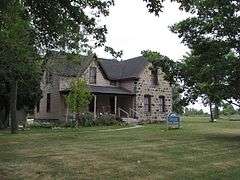
James and Jane Grice House |
|
000000001982-11-12-0000November 12, 1982
(#82000534) |
865 N. Huron Ave.
43°51′20″N 82°39′12″W / 43.855556°N 82.653333°W / 43.855556; -82.653333 (James and Jane Grice House) |
Harbor Beach |
|
| 4 |
Grindstone City Historic District |
Upload image |
000000001971-09-03-0000September 3, 1971
(#71000393) |
On M-25
44°03′16″N 82°53′53″W / 44.054444°N 82.898056°W / 44.054444; -82.898056 (Grindstone City Historic District) |
Grindstone City |
|
| 5 |
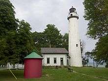
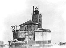
Harbor Beach Lighthouse |
|
000000001983-08-04-0000August 4, 1983
(#83000850) |
Breakwater Entrance
43°50′44″N 82°37′51″W / 43.845556°N 82.630833°W / 43.845556; -82.630833 (Harbor Beach Lighthouse) |
Harbor Beach |
|
| 6 |
Herman House |
Upload image |
000000001987-11-20-0000November 20, 1987
(#87001974) |
4405 Main St.
43°56′27″N 82°42′46″W / 43.940833°N 82.712778°W / 43.940833; -82.712778 (Herman House) |
Port Hope |
|
| 7 |
Huron City Historic District |
Upload image |
000000001995-04-28-0000April 28, 1995
(#95000446) |
Pioneer Dr., Huron and Port Austin Townships
44°01′52″N 82°49′57″W / 44.031111°N 82.8325°W / 44.031111; -82.8325 (Huron City Historic District) |
Huron City |
|
| 8 |
Indian Mission |
Upload image |
000000001972-09-22-0000September 22, 1972
(#72000620) |
590 E. Bay St.
43°43′33″N 83°26′32″W / 43.725833°N 83.442222°W / 43.725833; -83.442222 (Indian Mission) |
Sebewaing |
|
| 9 |
Charles G. Learned House |
|
000000001984-05-31-0000May 31, 1984
(#84001400) |
8544 Lake St.
44°02′32″N 82°59′38″W / 44.042222°N 82.993889°W / 44.042222; -82.993889 (Charles G. Learned House) |
Port Austin |
|
| 10 |
Isaac Leuty House |
Upload image |
000000001987-11-20-0000November 20, 1987
(#87001975) |
7955 School St.
43°56′26″N 82°42′54″W / 43.940556°N 82.715°W / 43.940556; -82.715 (Isaac Leuty House) |
Port Hope |
|
| 11 |
Masonic Temple |
|
000000001987-11-20-0000November 20, 1987
(#87001962) |
4425 Main St.
43°56′28″N 82°42′48″W / 43.941111°N 82.713333°W / 43.941111; -82.713333 (Masonic Temple) |
Port Hope |
|
| 12 |
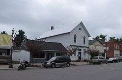
Melligan Store-Agriculture Hall |
Upload image |
000000001988-01-04-0000January 4, 1988
(#87001965) |
4432 Main St.
43°56′30″N 82°42′46″W / 43.941667°N 82.712778°W / 43.941667; -82.712778 (Melligan Store-Agriculture Hall) |
Port Hope |
|
| 13 |
Frank Murphy Birthplace |
Upload image |
000000001971-09-22-0000September 22, 1971
(#71000394) |
142 S. Huron St.
43°50′33″N 82°39′05″W / 43.8425°N 82.651389°W / 43.8425; -82.651389 (Frank Murphy Birthplace) |
Harbor Beach |
|
| 14 |
Navigation Structures at Harbor Beach Harbor |
Upload image |
000000001997-09-11-0000September 11, 1997
(#97000972) |
N. Lakeshore Dr.
43°50′54″N 82°38′15″W / 43.848333°N 82.6375°W / 43.848333; -82.6375 (Navigation Structures at Harbor Beach Harbor) |
Harbor Beach |
|
| 15 |
Ogilvie Building |
Upload image |
000000001987-11-20-0000November 20, 1987
(#87001973) |
4443 Main St.
43°56′29″N 82°42′49″W / 43.941389°N 82.713611°W / 43.941389; -82.713611 (Ogilvie Building) |
Port Hope |
|
| 16 |
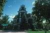
Pointe Aux Barques Lighthouse |
|
000000001973-03-20-0000March 20, 1973
(#73000949) |
East of Huron City on Light House Rd.
44°01′25″N 82°45′20″W / 44.023611°N 82.755556°W / 44.023611; -82.755556 (Pointe Aux Barques Lighthouse) |
Huron City |
|
| 17 |
Port Austin Reef Light |
|
000000002011-09-15-0000September 15, 2011
(#11000666) |
Port Austin Reef, 2.5 miles north of Port Austin (Port aux Barques Township)
44°04′55″N 82°58′55″W / 44.081944°N 82.981944°W / 44.081944; -82.981944 (Port Austin Reef Light) |
Port Austin vicinity |
Light Stations of the United States MPS
|
| 18 |
Albert E. Sleeper House |
Upload image |
000000001972-02-01-0000February 1, 1972
(#72000619) |
228 W. Huron St. (M-53)
43°46′01″N 83°00′32″W / 43.766944°N 83.008889°W / 43.766944; -83.008889 (Albert E. Sleeper House) |
Bad Axe |
|
| 19 |
Smith-Culhane House |
|
000000002001-09-24-0000September 24, 2001
(#01001015) |
8569 Lake St.
44°02′35″N 82°59′41″W / 44.043056°N 82.994722°W / 44.043056; -82.994722 (Smith-Culhane House) |
Port Austin |
|
| 20 |
St. John's Lutheran Church |
Upload image |
000000001987-11-20-0000November 20, 1987
(#87001964) |
4527 Second St.
43°56′26″N 82°43′07″W / 43.940556°N 82.718611°W / 43.940556; -82.718611 (St. John's Lutheran Church) |
Port Hope |
|
| 21 |
Stafford House |
Upload image |
000000001973-01-25-0000January 25, 1973
(#73000950) |
4467 Main St.
43°56′28″N 82°42′53″W / 43.941111°N 82.714722°W / 43.941111; -82.714722 (Stafford House) |
Port Hope |
|
| 22 |
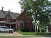
Frederick H. and Elizabeth Stafford House |
Upload image |
000000001987-11-20-0000November 20, 1987
(#87001976) |
4489 Main St.
43°56′30″N 82°42′53″W / 43.941667°N 82.714722°W / 43.941667; -82.714722 (Frederick H. and Elizabeth Stafford House) |
Port Hope |
|
| 23 |
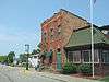
W. R. Stafford Flour Mill and Elevator |
Upload image |
000000001987-11-20-0000November 20, 1987
(#87001961) |
4310 Huron St.
43°56′31″N 82°42′29″W / 43.941944°N 82.708056°W / 43.941944; -82.708056 (W. R. Stafford Flour Mill and Elevator) |
Port Hope |
|
| 24 |
W. R. Stafford Planing Mill Site |
Upload image |
000000001987-11-20-0000November 20, 1987
(#87001960) |
Huron St.
43°56′29″N 82°42′27″W / 43.941389°N 82.7075°W / 43.941389; -82.7075 (W. R. Stafford Planing Mill Site) |
Port Hope |
|
| 25 |
W. R. Stafford Saw Mill Site |
Upload image |
000000001987-11-20-0000November 20, 1987
(#87001959) |
Huron St.
43°56′37″N 82°42′32″W / 43.943611°N 82.708889°W / 43.943611; -82.708889 (W. R. Stafford Saw Mill Site) |
Port Hope |
|
| 26 |
W. R. Stafford Worker's House |
Upload image |
000000001987-11-20-0000November 20, 1987
(#87001978) |
8022 Cedar St.
43°56′22″N 82°42′40″W / 43.939444°N 82.711111°W / 43.939444; -82.711111 (W. R. Stafford Worker's House) |
Port Hope |
|
| 27 |
Winsor and Snover Bank Building |
|
000000001987-03-19-0000March 19, 1987
(#87000482) |
8648 Lake St.
44°02′40″N 82°59′38″W / 44.044444°N 82.993889°W / 44.044444; -82.993889 (Winsor and Snover Bank Building) |
Port Austin |
|