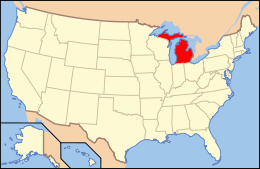
National Register of Historic Places listings in Branch County, Michigan
The following is a list of Registered Historic Places in Branch County, Michigan.
- This National Park Service list is complete through NPS recent listings posted December 16, 2016.[1]
| [2] | Name on the Register[3] | Image | Date listed[4] | Location | City or town | Description |
|---|---|---|---|---|---|---|
| 1 | Ezra E. and Florence (Holmes) Beardsley House | Upload image | (#15000157) |
1063 Holmes Rd 41°51′39″N 85°14′08″W / 41.860702°N 85.235505°W |
Bronson Township | |
| 2 | Coldwater Downtown Historic District | 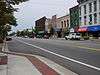 |
(#90001124) |
W. Chicago St. from Division to Clay Sts. 41°56′28″N 85°00′14″W / 41.941111°N 85.003889°W |
Coldwater | |
| 3 | Benedict Doll House | Upload image | (#90001238) |
665 W. Chicago St. 41°56′08″N 85°01′42″W / 41.935556°N 85.028333°W |
Coldwater | |
| 4 | East Chicago Street Historic District | Upload image | (#75000937) |
Chicago St. from Wright St. to Division St. including parks 41°56′21″N 84°59′40″W / 41.939167°N 84.994444°W |
Coldwater | Boundary increase I (added 1990-08-06): Roughly, Pearl St. between Hudson and Lincoln Sts. Boundary increase II (added 1990-08-06): Roughly, Church St. from Jefferson to Daugherty Sts., Hull St. from Morse St. to Park Pl., and Park from Church to Hull |
| 5 | First Presbyterian Church | .jpg) |
(#86002111) |
52 Marshall St. 41°56′32″N 85°00′01″W / 41.942222°N 85.000278°W |
Coldwater | |
| 6 | Abram C. Fisk House | Upload image | (#89002306) |
867 E. Chicago Rd. 41°56′06″N 84°57′52″W / 41.935°N 84.964444°W |
Coldwater | |
| 7 | Lanphere-Pratt House | Upload image | (#90001237) |
90 Division St. 41°56′16″N 85°00′08″W / 41.937778°N 85.002222°W |
Coldwater | |
| 8 | Marshall Street Historic District | Upload image | (#90001123) |
Roughly bounded by Taylor, Hull, N. Hudson, Montgomery and Clay Sts. 41°56′44″N 85°00′07″W / 41.945556°N 85.001944°W |
Coldwater | |
| 9 | South Monroe Street Historic District | Upload image | (#90001121) |
89-175 and 90-146 S. Monroe St. and 17 Park Ave. 41°56′13″N 85°00′14″W / 41.936944°N 85.003889°W |
Coldwater | |
| 10 | Stancer-Road-North Coldwater River Bridge | 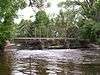 |
(#99001608) |
Stancer Rd. over N. Coldwater R. 42°01′17″N 85°05′27″W / 42.021389°N 85.090833°W |
Union Township | |
| 11 | US-12-Coldwater River Bridge | Upload image | (#99001609) |
Old US 12 over Coldwater Bridge 41°56′40″N 85°01′52″W / 41.944444°N 85.031111°W |
Coldwater | |
| 12 | West Pearl Street Historic District | Upload image | (#90001122) |
155-225 and 160-208 W. Pearl St. 41°56′26″N 85°00′32″W / 41.940556°N 85.008889°W |
Coldwater | |
| 13 | Wing House | Upload image | (#75000938) |
27 S. Jefferson St. 41°56′20″N 84°59′51″W / 41.938889°N 84.9975°W |
Coldwater |
See also
| Wikimedia Commons has media related to National Register of Historic Places in Branch County, Michigan. |
- List of Registered Historic Places in Michigan
- List of Michigan State Historic Sites in Branch County, Michigan
References
- ↑ "National Register of Historic Places: Weekly List Actions". National Park Service, United States Department of the Interior. Retrieved on December 16, 2016.
- ↑ Numbers represent an ordering by significant words. Various colorings, defined here, differentiate National Historic Landmarks and historic districts from other NRHP buildings, structures, sites or objects.
- ↑ National Park Service (2008-04-24). "National Register Information System". National Register of Historic Places. National Park Service.
- ↑ The eight-digit number below each date is the number assigned to each location in the National Register Information System database, which can be viewed by clicking the number.
| Lists by county |
|   |
|---|---|---|
| Other lists |
| |
| Topics | |
|---|---|
| Lists by states |
|
| Lists by insular areas | |
| Lists by associated states | |
| Other areas | |
| |
This article is issued from Wikipedia - version of the 5/16/2016. The text is available under the Creative Commons Attribution/Share Alike but additional terms may apply for the media files.