Plush, Dorset
| Plush | |
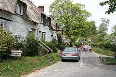 The Brace Of Pheasants public house, Plush |
|
 Plush |
|
| OS grid reference | ST715022 |
|---|---|
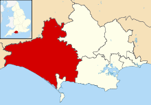
| District | West Dorset |
| Shire county | Dorset |
| Region | South West |
| Country | England |
| Sovereign state | United Kingdom |
| Police | Dorset |
| Fire | Dorset and Wiltshire |
| Ambulance | South Western |
| EU Parliament | South West England |
Coordinates: 50°49′06″N 2°24′24″W / 50.8183°N 2.4068°W
Plush is a small village in the English county of Dorset. It lies within the civil parish of Piddletrenthide in the West Dorset administrative district, about 8 miles (13 km) north of the county town Dorchester. It is sited in a small side-valley of the River Piddle at an altitude of 130 metres (430 ft) and is surrounded by chalk hills which rise to 251 metres (823 ft) at Ball Hill, a kilometre to the northeast, and 261 metres (856 ft) at Lyscombe Hill, 2½ kilometres to the east.
Plush consists of a few thatched cottages, a public house, a Regency manor house and a small church dedicated to St John the Baptist; the church was designed in 1848 by Benjamin Ferrey, a Gothic Revival architect and close friend of Pugin.[1]
See also
References
- ↑ Dorset: The Buildings of England by John Newman and Nikolaus Pevsner. Page 317. Published by Penguin Books 1972. Reprinted 1975. ISBN 0-14-071044-2