Askerswell
| Askerswell | |
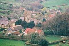 Askerswell village from the south |
|
 Askerswell |
|
| Population | 154 [1] |
|---|---|
| OS grid reference | SY529927 |
| – London | 140 miles (225 km) |
| Civil parish | Askerswell |
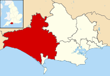
| District | West Dorset |
| Shire county | Dorset |
| Region | South West |
| Country | England |
| Sovereign state | United Kingdom |
| Post town | DORCHESTER |
| Postcode district | DT2 |
| Dialling code | 01308 |
| Police | Dorset |
| Fire | Dorset and Wiltshire |
| Ambulance | South Western |
| EU Parliament | South West England |
| UK Parliament | West Dorset |
| Website | http://www.askerswell.co.uk/ |
Coordinates: 50°43′58″N 2°40′07″W / 50.7327°N 2.6687°W
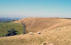
Askerswell /ˈæskərzwəl/ is a small village and civil parish in the county of Dorset in southwest England. It is sited on the small River Asker. It lies within the West Dorset administrative district, 11 miles (18 km) west of the county town Dorchester. The parish has an area of 698 hectares (1,724 acres)[2] and in the northeast includes the western slopes of Eggardon Hill, including part of the Iron Age hill fort close to its summit.[3][4] In the 2011 census the civil parish had a population of 154.
Toponymy
The name Askerswell is derived from Osgar's Well or its Viking equivalent Asger's Well, though local tradition is that Askers' Well is Dorset dialect for newts' well and refers to the name of the stream flowing through the village ("Askers" or the River Asker).[5]
History
In 1086 in the Domesday Book Askerswell was recorded as Oscherwille;[6] it had 30 households, was in Eggardon Hundred and the lord and tenant-in-chief was Tavistock Abbey.[7]
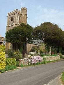
Askerswell parish church has an early 15th-century west tower, but the rest of the building was rebuilt by Talbot Bury in 1858.[8][5]
There are twenty structures in the parish that are listed by English Heritage for their historic or architectural interest. There are no structures listed as Grade I (the highest rating), but the parish church and South Eggardon Farmhouse are Grade II*.[9]
Governance
In the United Kingdom national parliament Askerswell is in the West Dorset parliamentary constituency, which is currently represented by Oliver Letwin of the Conservative Party. In local government, Askerswell is governed by Dorset County Council at the highest tier and West Dorset District Council at the middle tier. At the parish level—the lowest tier—Askerswell does not have a parish council; instead it has a parish meeting.[10]
In national parliament and district council elections, West Dorset is divided into 24 electoral wards, with Askerswell being within Netherbury electoral ward.[11][12][13] In district council elections these 24 wards elect 42 councillors to West Dorset District Council, with Netherbury ward electing one of these. The Conservative Party currently have overall control of the district council.[14] In county council elections, Askerswell is in the Bride Valley electoral division, one of 42 divisions that elect councillors to Dorset County Council.[15]
Geography
Askerswell civil parish extends from the A35 trunk road on Askerswell Down in the south to the Iron Age hillfort on Eggardon Hill in the northeast and Knowle Hill in the northwest. Its altitude is between about 50 metres (160 ft) where the River Asker leaves the parish in the west up to about 250 metres (820 ft) on Eggardon Hill. The surrounding parishes are Loders to the west, Shipton Gorge to the southwest, Chilcombe to the south, Litton Cheney to the southeast and east, West Compton to the northeast and Powerstock to the north.[16] All of Askerswell parish is within the Dorset Area of Outstanding Natural Beauty.[17]
The local travel links are located 5 miles (8.0 km) from the village to Maiden Newton railway station and 33 miles (53 km) to Exeter International Airport. The main road running through the village is Hembury Road.
Demography
In the 2011 census Askerswell civil parish had 86 dwellings,[18] 71 households and a population of 154.[1] The average age of residents was 51.7, compared to 39.3 for England as a whole. 27.9% of residents were age 65 or over, compared to 16.4% for England as a whole.[19]
Amenities
Askerswell village has a village hall, located by the road to Spyway.[20]
References
- 1 2 "Area: Askerswell (Parish). Key Figures for 2011 Census: Key Statistics". Neighbourhood Statistics. Office for National Statistics. Retrieved 12 June 2013.
- ↑ "Askerswell". Dorset OPC Project. Retrieved 3 April 2015.
- ↑ West Dorset. West Dorset District Council. 1982. p. 2.
- ↑ Ordnance Survey 1:25000 Pathfinder Series, Sheet SY 49/59 Bridport, 1977
- 1 2 Hannay, Clive; Legg, Rodney (December 2007). "Askerswell village". Dorset Life magazine. Retrieved 3 April 2015.
- ↑ "Dorset A-G". The Domesday Book Online. domesdaybook.co.uk. Retrieved 17 February 2015.
- ↑ "Place: Askerswell". Open Domesday. domesdaymap.co.uk. Retrieved 17 February 2015.
- ↑ "'Askerswell', in An Inventory of the Historical Monuments in Dorset, Volume 1, West (London, 1952), pp. 12–15". British History Online. University of London. Retrieved 2 April 2015.
- ↑ "Listed Buildings in Askerswell, Dorset, England". britishlistedbuildings.co.uk. Retrieved 3 April 2015.
- ↑ "Askersewll Parish Meeting". dorsetforyou.com. Dorset County Council. 8 December 2014. Retrieved 4 April 2015.
- ↑ "The West Dorset (Electoral Changes) Order 2015". legislation.gov.uk. Retrieved 30 September 2015.
- ↑ "Dorset West: Seat, Ward and Prediction Details". electoralcalculus.co.uk. Retrieved 30 September 2015.
- ↑ "Interactive map of District councillors". dorsetforyou.com. Dorset County Council. Retrieved 30 September 2015.
- ↑ "West Dorset district councillors". dorsetforyou.com. Dorset County Council. 15 June 2015. Retrieved 30 September 2015.
- ↑ "Electoral division profiles 2013". dorsetforyou.com. Dorset County Council. Retrieved 4 April 2015.
- ↑ Ordnance Survey (1977), 1:25,000 Pathfinder Series, Sheet SY 49/59 (Bridport)
- ↑ "Dorset Explorer". Natural England. Retrieved 4 April 2015.
- ↑ "Area: Askerswell (Parish). Dwellings, Household Spaces and Accommodation Type, 2011 (KS401EW)". Neighbourhood Statistics. Office for National Statistics. Retrieved 17 February 2015.
- ↑ "Area: Askerswell (Parish). Age Structure, 2011 (KS102EW)". Neighbourhood Statistics. Office for National Statistics. Retrieved 4 April 2015.
- ↑ "Askerswell Village Hall". Dorset Halls Network. Dorset Village Halls Association. Retrieved 4 April 2015.
External links
-
 Media related to Askerswell at Wikimedia Commons