Warmwell

Coordinates: 50°41′25″N 2°20′27″W / 50.6904°N 2.3409°W
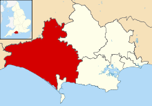
Warmwell is a small village and civil parish in south west Dorset, England, situated on the B3390 road about 5 miles (8.0 km) southeast of Dorchester. In 2013 the estimated population of the parish was 80.[1]
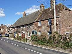
Warmwell contains several historic buildings, including a Jacobean manor house,[2] and from May 1937 was the home of RAF Station Woodsford airfield (later renamed RAF Warmwell), which is now a popular holiday site and contains a caravan park and several other small businesses.
References
- 1 2 "Parish Population Data". Dorset County Council. 20 January 2015. Retrieved 11 March 2015.
- ↑ West Dorset, Holiday and Tourist Guide. West Dorset District Council. c. 1982. p. 21.
External links
![]() Media related to Warmwell at Wikimedia Commons
Media related to Warmwell at Wikimedia Commons
This article is issued from Wikipedia - version of the 4/23/2015. The text is available under the Creative Commons Attribution/Share Alike but additional terms may apply for the media files.