Packhorse bridge


A packhorse bridge is a bridge intended to carry packhorses (horses loaded with sidebags or panniers) across a river or stream. Typically a packhorse bridge consists of one or more narrow (one horse wide) masonry arches, and has low parapets so as not to interfere with the horse's panniers.[1] Multi-arched examples sometimes have triangular cutwaters that are extended upwards to form pedestrian refuges.[2]:24–25
Packhorse bridges were often built on the trade routes (often called packhorse routes) that formed major transport arteries across Europe and Great Britain until the coming of the turnpike roads and canals in the 18th century.[1] Before the road-building efforts of Napoleon, all crossings of the Alps were on packhorse trails.[3] Travellers' carriages were dismantled and transported over the mountain passes by ponies and mule trains.
Definition
In the British Isles at least, the definition of a packhorse bridge is somewhat nebulous. Ernest Hinchliffe discusses the difficulty of defining a true packhorse bridge in A Guide to the Packhorse Bridges of England.[2] He claims that "before the eighteenth century bridges were described as 'horse bridges' or 'cart bridges'" and his strict definition excludes the latter. He suggests that a classic packhorse bridge should generally be:
- less than 6 feet (1.8 m) in width;
- built before 1800;
- on a recognised packhorse route.
He categorises the 190 English bridges listed in his book into three groups:
- Group 1: 6 feet (1.8 m) wide or less, built before 1800 and with known packhorse associations;
- Group 2: bridges that fail one or other of the above criteria, but which are generally referred to as packhorse bridges;
- Group 3: bridges sometimes claimed as packhorse bridges but dismissed as such by the author.[2]:6–7
The difficulty of classification is illustrated by Moulton Bridge in Suffolk, which Hinchliffe places in Group 1 but which English Heritage describe as "perhaps not strictly a packhorse bridge since it was wide enough to take carts".[4]
List of packhorse bridges in the British Isles
The following list includes all Listed Buildings described as packhorse bridges by English Heritage, Cadw or Historic Scotland; all 106 of Hinchliffe's Group 1 bridges in England; and certain other candidates. (For England, Hinchliffe's Group numbers are given as superscripts after the bridge name.)
England
| County | Location | NameGroup | Photograph | Crosses | Notes |
|---|---|---|---|---|---|
| Bedfordshire | Sutton 52°06′42″N 0°13′08″W / 52.1117°N 0.2190°W |
Sutton Packhorse Bridge1 |  |
Potton Brook | Medieval with later repairs; two pointed arches. Grade II* listed,[5] Scheduled Ancient Monument.[6] |
| Cheshire | Crowton 53°16′13″N 2°37′34″W / 53.2702°N 2.6262°W |
Acton Brook | Single segmental arch. Carries public bridleway. | ||
| Cheshire | Hockenhull Platts 53°11′10″N 2°47′05″W / 53.1861°N 2.7848°W |
Roman Bridges1 | River Gowy | Three bridges, "probably late 18th-century"[7] or "late 17th-century".[8] Grade II listed.[7][9] The three bridges carry a public byway. | |
| Cheshire | Quarry Bank Mill, Styal 53°20′38″N 2°15′01″W / 53.3440°N 2.2503°W |
The Packhorse Bridge |  |
River Bollin | 1820, single segmental arch. Grade II listed.[10] Carries a public byway. |
| Cheshire/Derbyshire | Three Shire Heads 53°12′50″N 1°59′15″W / 53.2139°N 1.9875°W |
Three Shire Heads Bridge2 | River Dane | Probably late 18th-century; single span. Grade II listed.[11] Carries public byway. | |
| Cornwall | Bowithick 50°36′55″N 4°34′09″W / 50.6154°N 4.5691°W |
Bowithick Bridge | 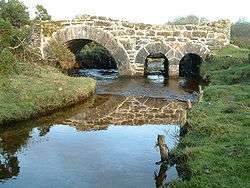 |
Penpont Water | Probably early 19th-century; three stone arches, one larger and two small. Grade II listed.[12] |
| Cornwall | Launceston 50°38′29″N 4°21′58″W / 50.641492°N 4.366202°W |
West Bridge (Prior's Bridge) | River Kensey | Late medieval; five-span bridge with two cut-waters. Grade I listed.[13] | |
| Cumbria | Ambleside 54°27′09″N 2°57′33″W / 54.4525°N 2.9592°W |
High Sweden Bridge1 | Scandale Beck | Late 17th-century; single-span. Grade II listed.[14] Carries public footpath. | |
| Cumbria | Barbon 54°13′50″N 2°35′37″W / 54.2306°N 2.5937°W |
High Beckfoot Bridge1 | Barbon Beck | Probably late 17th- or 18th-century; described as "ruinous" in 1725.[8] Single-span. Grade II listed.[15] Carries public bridleway. | |
| Cumbria | Dean 54°37′29″N 3°27′33″W / 54.6246°N 3.4592°W |
Calva Hall packhorse bridge1 |  |
River Marron | Dated 1697;[2]:38 single-span. Grade II listed.[16] |
| Cumbria | Drigg 54°22′32″N 3°25′21″W / 54.3756°N 3.4224°W |
Drigg Holme Packhorse Bridge1 |  |
River Irt | Single-span. Scheduled Ancient Monument.[17] Carries public bridleway. |
| Cumbria | Eskdale 54°23′44″N 3°15′00″W / 54.3956°N 3.2499°W |
Doctor[s] Bridge2 |  |
River Esk | Probably 17th-century, widened in 1734. Grade II listed.[18] Carries public road. |
| Cumbria | Gaisgill 54°27′10″N 2°33′39″W / 54.4527°N 2.5609°W |
Barugh Bridge1 | Rais Gill | Probably 18th-century, but maybe earlier. Grade II listed.[19] Carries public byway. | |
| Cumbria | Knock 54°39′02″N 2°28′45″W / 54.6506°N 2.4791°W |
Swindale Beck | Possibly 17th-century; single segmental arch. Grade II listed.[20] | ||
| Cumbria | Little Langdale 54°25′04″N 3°03′42″W / 54.4178°N 3.0616°W |
Slater[s] Bridge1 |  |
River Brathay | 17th-century; two clapper slabs and a single arch. Grade II* listed.[21] Carries public footpath. |
| Cumbria | Lowgill 54°21′44″N 2°35′32″W / 54.3621°N 2.5921°W |
Lowgill Packhorse Bridge | Lowgill Beck | Probably 17th- or 18th-century; single-span. Grade II listed.[22] | |
| Cumbria | Pennington 54°12′24″N 3°08′28″W / 54.2066°N 3.1411°W |
Devil's Bridge1 | Rathmoss Beck | 17th- or 18th-century; single-span. Grade II listed.[23] Alongside public road. | |
| Cumbria | Sca Fell 54°25′20″N 3°11′32″W / 54.4221°N 3.1923°W |
Lingcove or Throstlegarth Bridge1 | Lingcove Beck | Single arch. On Open Access land. | |
| Cumbria | Seathwaite, Allerdale 54°29′16″N 3°10′59″W / 54.4877°N 3.1830°W |
Stockley Bridge2 |  |
Grains Gill | Early- or mid-18th-century; single span. Grade II listed.[24] Carries public bridleway. |
| Cumbria | Shap 54°32′11″N 2°43′11″W / 54.5364°N 2.7197°W |
Parish Crag Bridge1 |  |
Swindale Beck | Probably 18th-century; single span. Grade II listed.[25] Carries public footpath. |
| Cumbria | Shap 54°32′16″N 2°45′05″W / 54.5378°N 2.7515°W |
Park Bridge2 |  |
Haweswater Beck | 1860–69; single span.[26] Carries public footpath. |
| Cumbria | Stainton 54°16′00″N 2°43′58″W / 54.2666°N 2.7327°W |
packhorse bridge1 | Stainton Beck | Probably 17th-century; single segmental arch. Grade II listed.[27] Adjacent to ford. | |
| Cumbria | Ullock 54°36′07″N 3°25′54″W / 54.6020°N 3.4318°W |
packhorse bridge1 | Black Beck | Single span.[2]:52 | |
| Cumbria | Wasdale Head 54°28′06″N 3°15′24″W / 54.4682°N 3.2567°W |
Row Bridge1 |  |
Mosedale Beck | Probably 18th-century; single span. Grade II listed.[28] |
| Cumbria | Watendlath 54°32′14″N 3°07′17″W / 54.5371°N 3.1214°W |
Watendlath Packhorse Bridge1 | Watendlath Beck | 18th-century; single span. Grade II listed.[29] Carries public bridleway. | |
| Cumbria | Wilton 54°28′44″N 3°26′46″W / 54.4790°N 3.4460°W |
Monk's Bridge1 |  |
River Calder | Probably 17th- or 18th-century; single span. Also known as High Wath Bridge, Mattie Benn's Bridge, Hannah Benn Bridge and Roman Bridge.[2]:46 Grade II listed.[30] |
| Cumbria | Winster 54°20′27″N 2°54′18″W / 54.3408°N 2.9051°W |
tributary of River Winster | Probably 17th-century. Grade II listed.[31] Adjacent to A5074 road. | ||
| Cumbria | Winster 54°19′37″N 2°54′08″W / 54.3269°N 2.9021°W |
Winster Bridge1 | River Winster | 1729 with 20th-century parapet; single span. Grade II listed.[32] | |
| Derbyshire | Ashford-in-the-Water 53°13′24″N 1°42′37″W / 53.2232°N 1.7104°W |
Sheepwash Bridge2 | River Wye | 18th-century; three low arches, with integral walled sheep pen on southern bank. Grade II* listed,[33] Scheduled Ancient Monument. | |
| Derbyshire | Bakewell 53°13′03″N 1°40′44″W / 53.2175°N 1.6788°W |
Holme Bridge1 | River Wye | 1664; five segmental arches. Grade I listed,[34] Scheduled Ancient Monument.[35] Carries public bridleway. | |
| Derbyshire | Edale 53°22′16″N 1°48′58″W / 53.3710°N 1.8161°W |
Gibraltar Bridge1 |  |
Grindsbrook | 18th-century; single span. Grade II listed.[36] Carries public footpath. |
| Derbyshire | Edale 53°22′20″N 1°52′07″W / 53.3721°N 1.8687°W |
Youngate or Jacob's Ladder Bridge1 |  |
River Noe | Possibly 17th-century; single span. Grade II listed.[37] Carries public bridleway (part of the Pennine Way). |
| Derbyshire | nr Errwood Hall 53°15′23″N 1°58′55″W / 53.2563°N 1.9820°W |
Goyts Bridge1 |  |
River Goyt | Moved to current position in 1968 from Goyt's Bridge hamlet. In open access land. |
| Derbyshire | Hayfield 53°22′48″N 1°55′35″W / 53.3801°N 1.9263°W |
Bowden Bridge1 |  |
River Kinder | Probably 18th-century; single-span. Grade II listed.[38] Carries public footpath. |
| Derbyshire/Staffordshire | Hollinsclough 53°11′56″N 1°54′26″W / 53.1988°N 1.9072°W |
Hopping Packhorse Bridge1 |  |
River Dove | Single semicircular arch.[2]:114–115 Carries public bridleway. |
| Derbyshire/Staffordshire | Hollinsclough 53°12′12″N 1°55′24″W / 53.2034°N 1.9232°W |
Washgate Bridge1 | River Dove | Early 18th-century; single-span. Grade II listed, "A rare example of a perfectly preserved packhorse bridge."[39] Carries public byway. | |
| Derbyshire/South Yorkshire | Howden Reservoir 53°27′09″N 1°44′48″W / 53.4526°N 1.7467°W |
Slippery Stones Bridge2 |  |
River Derwent | 1672; two segmental arches. Rebuilt 1959 after relocation from Derwent village. Grade II listed,[40] Scheduled Ancient Monument.[41] Carries public bridleway. |
| Derbyshire | Lea Hall 53°03′28″N 1°42′26″W / 53.0577°N 1.7073°W |
Bradbourne Brook | 17th-century or earlier; single pointed arch. Formerly Grade II listed, now delisted.[42] On private land. | ||
| Derbyshire/South Yorkshire | Longdendale 53°29′46″N 1°47′42″W / 53.4962°N 1.7950°W |
Ladyshaw Bridge |  |
Salter's Brook | 17th-century; single-span. Carries public byway, part of the Trans-Pennine Trail. |
| Derbyshire/Staffordshire | Milldale 53°05′20″N 1°47′38″W / 53.0890°N 1.7938°W |
Viator's Bridge1 |  |
River Dove | 17th-century or earlier; two segmental arches. Grade II listed.[43] Carries public footpath. Mentioned in The Compleat Angler (1653) by Izaak Walton. |
| Derbyshire | Youlgreave 53°10′24″N 1°40′48″W / 53.1732°N 1.6799°W |
Bradford Packhorse Bridge1 | River Bradford | 18th-century, single segmental arch. Grade II listed.[44] Carries public bridleway. | |
| Derbyshire | Youlgreave 53°11′00″N 1°40′49″W / 53.1833°N 1.6804°W |
Coalpit Bridge1 |  |
River Lathkill | Mid-18th-century; three segmental arches. Grade II listed.[45] Carries public bridleway. |
| Devon | Brendon 51°13′14″N 3°45′50″W / 51.2205°N 3.7639°W |
Packhorse Bridge |  |
East Lyn River | Probably 17th- or 18th-century; single round arch. Grade II listed.[46] |
| Devon | Drewsteignton 50°41′44″N 3°46′52″W / 50.6955°N 3.7810°W |
Fingle Bridge |  |
River Teign | 17th-century Grade II* listed three-arch granite bridge carrying unclassified road with pedestrian refuges over cutwaters.[47] |
| Devon | Membury 50°48′30″N 3°02′39″W / 50.8082°N 3.0442°W |
Beckford Bridge1 |  |
River Yarty | 18th- or 19th-century; single-span. Grade II listed,[48] Scheduled Ancient Monument.[49] |
| Devon | Sidford 50°42′10″N 3°13′22″W / 50.7029°N 3.2229°W |
Sidford Bridge1 |  |
River Sid | Said to be 12th-century. Grade II listed. Parapets of original packhorse bridge incorporated into widened road bridge of 1930 carrying A3052 road.[50] |
| Devon | Westcott Barton Marwood, Devon 51°07′37″N 4°06′03″W / 51.1269°N 4.1007°W |
Knowl Water | Probably 18th- or early 19th-century. Grade II listed.[51] Carries public footpath. | ||
| Dorset | near Corfe Castle 50°39′45″N 2°02′55″W / 50.6626°N 2.0485°W |
Sharford Bridge1 |  |
Corfe River | Scheduled Ancient Monument.[52] Carries public bridleway. |
| Dorset | Fifehead Neville 50°53′57″N 2°19′33″W / 50.8993°N 2.3257°W |
Fifehead Neville Packhorse Bridge1 | River Divelish | Probably medieval. Grade II listed; two pointed arches.[53] Carries footpath alongside ford on public road. | |
| Dorset | Gussage St Michael 50°54′45″N 2°01′42″W / 50.9126°N 2.0282°W |
packhorse bridge |  |
River Allen | Probably 18th-century; single semicircular arch. Grade II listed.[54] Carries public footpath. |
| Dorset | Holwell 50°54′25″N 2°25′45″W / 50.9069°N 2.4291°W |
packhorse bridge1 | Caundle Brook | Probably medieval, with 19th- and 20th-century alterations. Grade II listed.[55] Carries public bridleway. | |
| Dorset | Rampisham 50°49′07″N 2°37′24″W / 50.8187°N 2.6232°W |
packhorse bridge1 |  |
River Frome | 16th- or 17th-century alterations; three pointed arches. Grade II listed.[56] Carries public bridleway. |
| Dorset | Sturminster Marshall 50°48′04″N 2°04′42″W / 50.8010°N 2.0782°W |
packhorse bridge1 |  |
River Winterborne | 17th-century; single cambered arch. Grade II listed.[57] Carries public bridleway. |
| Dorset | Tarrant Monkton 50°52′51″N 2°04′45″W / 50.8808°N 2.0793°W |
packhorse bridge1 |  |
River Tarrant | Probably 17th-century; 3 segmental arches. Grade II listed.[58] Alongside ford on public road. |
| Durham | Bowes 54°32′06″N 1°59′57″W / 54.5350°N 1.9992°W |
Nabb Bridge1 |  |
Deepdale Beck | 1699 per datestone (contra English Heritage listing, which says "Mid C18"); single segmental arch. Grade II listed.[59] |
| Durham | Brafferton 54°34′06″N 1°31′58″W / 54.5682°N 1.5328°W |
Ketton Packhorse Bridge1 | River Skerne | Late 17th- or early 18th-century; single segmental arch. Grade II listed.[60] | |
| Durham | Cornsay 54°47′39″N 1°46′55″W / 54.7941°N 1.7819°W |
Pan Burn | Possibly early 18th-century; single wide segmental arch. Grade II listed.[61] On private land. | ||
| Durham | Egglestone Abbey 54°31′56″N 1°54′19″W / 54.5322°N 1.9052°W |
Bow Bridge1 |  |
Thorsgill Beck | 17th-century; single round arch.[2]:56 Grade II listed.[62] |
| Durham | Headlam 54°33′55″N 1°43′28″W / 54.5653°N 1.7245°W |
packhorse bridge1 |  |
Headlam or Dyance Beck | Probably 18th-century; single round arch. Grade II listed.[63] |
| Durham | West Hope 54°28′44″N 1°57′09″W / 54.4788°N 1.9524°W |
West Hope Packhorse Bridge1 | Hill or Waitgill Beck | Single segmental arch.[2]:59 | |
| Essex | Feering 51°50′25″N 0°42′26″E / 51.8402°N 0.7071°E |
Roman Arches | River Blackwater | c.1750; seven brick arches. Under restoration.[64] | |
| Gloucestershire | Slad 51°46′16″N 2°09′53″W / 51.7711°N 2.1647°W |
packhorse bridge1 |  |
Dillay Brook | Carries public footpath. |
| Gloucestershire/Warwickshire | Todenham 52°02′09″N 1°38′38″W / 52.0357°N 1.6440°W |
packhorse bridge1 | _-_geograph.org.uk_-_1619854.jpg) |
Knee Brook | Possibly 16th-century in origin, rebuilt 18th century; two semicircular arches. Grade II listed.[65] Carries public bridleway. |
| Gloucestershire | Wickwar 51°35′29″N 2°23′22″W / 51.5914°N 2.3895°W |
Sturt Bridge1 | Little Avon River | Also known as Roman Arch. Probably late medieval or 16th-/17th-century; two arches. Grade II listed.[66] Carries public footpath. | |
| Greater Manchester | Prestolee 53°33′08″N 2°22′36″W / 53.5523°N 2.3767°W |
Prestolee Bridge1 | River Irwell | Late 18th-century; five semicircular arches with cutwaters. Grade II listed.[67] | |
| Greater Manchester | Strines 53°22′58″N 2°03′05″W / 53.3829°N 2.0515°W |
Roman Bridge1 | River Goyt | 18th-century; single segmental span. Grade II listed.[68][69] Carries public bridleway. | |
| Greater Manchester | Uppermill 53°33′14″N 2°00′33″W / 53.5540°N 2.0091°W |
 |
Diggle Brook | "Medieval". Adjacent to Oldham & Ripponden Trust Turnpike bridge (1864)[70] and Brownhill Bridge Mill, which is Grade II listed.[71] | |
| Kent | Eynsford 51°22′05″N 0°12′39″E / 51.3680°N 0.2109°E |
Eynsford Bridge | River Darent | 17th-century, two round arches. Grade II listed.[72] | |
| Lancashire | Barrowford 53°51′28″N 2°12′38″W / 53.8577°N 2.2105°W |
Higherford Old Bridge2 |  |
Pendle Water | 16th/17th-century, parapets added 1814–15; single span. Grade II* listed,[73] Scheduled Ancient Monument.[74] |
| Lancashire | Bleasdale 53°54′24″N 2°39′44″W / 53.9066°N 2.6621°W |
Brooks Packhorse Bridge1 |  |
River Brock | Single-span. Listed per Hinchliffe,[2]:61 but not in English Heritage listings. |
| Lancashire | Catlow Bottoms 53°49′22″N 2°10′37″W / 53.8227°N 2.1770°W |
packhorse bridge1 | Catlow Brook | "Perhaps C17"; single semicircular arch. Grade II listed.[75] | |
| Lancashire | Capernwray 54°08′27″N 2°43′22″W / 54.1408°N 2.7228°W |
River Keer | Date uncertain; single semi-elliptical arch. Grade II listed.[76] | ||
| Lancashire | Wycoller 53°50′58″N 2°06′15″W / 53.8494°N 2.1043°W |
Wycoller Packhorse Bridge1 |  |
Wycoller Beck | 17th-century or perhaps earlier; two segmental arches. Grade II* listed,[77] Scheduled Ancient Monument.[78] Carries a public footpath. |
| Leicestershire | Anstey 52°40′16″N 1°11′05″W / 52.6711°N 1.1847°W |
Anstey Bridge1 |  |
Rothley Brook | Also known as The Old Bridge. Dated by W.G.Hoskins as c. 1500, by Jervoise as late 17th-century, and by English Heritage as 16th/17th-century;[2]:121 five arches. Grade II* listed,[79] Scheduled Ancient Monument.[80] Carries public footpath. |
| Leicestershire | Anstey 52°40′30″N 1°10′43″W / 52.6750°N 1.1785°W |
King William's Bridge3 |  |
Rothley Brook | Probably 17th-century; two round arches. Grade II listed.[81] Carries public bridleway. |
| Leicestershire | Aylestone 52°36′12″N 1°09′46″W / 52.6033°N 1.1629°W |
Aylestone Old Bridge1 | River Soar | Also known as the Roman Bridge. Probably 15th-century; eleven small arches (eight on bridge, three on causeway). Grade II* listed,[82] Scheduled Ancient Monument.[83] | |
| Leicestershire | Medbourne 52°31′45″N 0°49′18″W / 52.5292°N 0.8218°W |
packhorse bridge1 | Medbourne Brook | Possibly 13th-century; four arches. Scheduled Ancient Monument.[84] | |
| Leicestershire | Rearsby 52°43′27″N 1°02′15″W / 52.7243°N 1.0375°W |
Seven Arch Bridge1 | Rearsby Brook | Pevsner says medieval, but datestone says 1714; seven semicircular arches, one almost buried. Grade II listed.[85] | |
| Leicestershire | Thurcaston 52°41′34″N 1°09′57″W / 52.6929°N 1.1658°W |
Sandham Bridge1 | Rothley Brook | Three similar bridges between Thurcaston and Cropston: Sandham Bridge (52°41′34″N 1°09′57″W / 52.6929°N 1.1658°W) and Coffin Bridge (52°41′24″N 1°10′25″W / 52.6900°N 1.1736°W), both with two arches, and a third, single-span, bridge at 52°41′33″N 1°09′56″W / 52.6924°N 1.1655°W. All three are 16th- or 17th-century and separately Grade II listed.[86][87][88] | |
| Lincolnshire | Utterby 53°25′10″N 0°02′13″W / 53.4194°N 0.0369°W |
Utterby Packhorse Bridge1 | 14th-century; double chamfered cambered arch. Grade II* listed'[89] | ||
| Lincolnshire | West Rasen 53°23′22″N 0°24′10″W / 53.3895°N 0.4028°W |
Bishop's Bridge1 | River Rase | 15th-century; three segmental arches. Grade II* listed,[90] Scheduled Ancient Monument.[91] | |
| Norfolk | Walsingham 52°53′38″N 0°52′37″E / 52.8940°N 0.8770°E |
packhorse bridge1 | River Stiffkey | Original date unknown, probably reconstructed late 19th century; four small arches. Grade II listed.[92] In grounds of Walsingham Abbey. | |
| Northamptonshire | Charwelton 52°12′01″N 1°13′07″W / 52.2003°N 1.2186°W |
Charwelton Bridge1 |  |
River Cherwell | Probably 15th-century; two pointed arches. Grade II listed,[93] Scheduled Ancient Monument.[94] Carries roadside pavement. |
| Northumberland | Ovingham 54°58′02″N 1°52′15″W / 54.9672°N 1.8709°W |
Ovingham Packhorse Bridge1 | Whittle Burn | 18th-century per English Heritage (Hinchliffe says 1698[2]:65); two segmental arches. Grade II listed.[95] | |
| North Yorkshire | Aldbrough St John 54°29′51″N 1°41′21″W / 54.4975°N 1.6893°W |
packhorse bridge1 |  |
Aldbrough Beck | Possibly 16th- or 17th-century; three segmental pointed arches. Grade II listed.[96] Carries public footpath. |
| North Yorkshire | Birstwith 54°02′17″N 1°38′29″W / 54.0381°N 1.6415°W |
New Bridge1 |  |
River Nidd | Also known as Haxby Bridge. 1822; single-span. Grade II listed.[97] Carries public right-of-way. |
| North Yorkshire | Boltby 54°16′22″N 1°14′49″W / 54.2728°N 1.2470°W |
packhorse bridge1 |  |
Gurtof Beck | Single semicircular arch.[2]:67 |
| North Yorkshire | Clapham 54°07′07″N 2°23′30″W / 54.1185°N 2.3918°W |
Brokken Bridge1 |  |
Clapham Beck | Probably 18th-century; single segmental arch.[98] Carries public footpath. |
| North Yorkshire | Croft-on-Tees 54°29′05″N 1°34′05″W / 54.4848°N 1.5680°W |
Clow Beck Packhorse Bridge1 |  |
Clow Beck | Possibly 15th-century; two segmental arches on differing alignments. Grade II listed.[99] Carries public bridleway. |
| North Yorkshire | Glaisdale 54°26′20″N 0°47′32″W / 54.4389°N 0.7921°W |
Beggars Bridge2 |  |
River Esk | 1619; single segmental arch. Grade II* listed.[100] Carries public footpath. |
| North Yorkshire | Hampsthwaite 54°01′25″N 1°36′17″W / 54.0236°N 1.6048°W |
Cockhill Packhorse Bridge1 |  |
Cockhill Beck | Probably 17th-century; single small semicircular arch. Grade II listed.[101] |
| North Yorkshire | Hubberholme 54°12′18″N 2°06′03″W / 54.2049°N 2.1008°W |
Crook Gill Bridge1 |  |
Crook Gill | Single segmental arch.[2]:72 |
| North Yorkshire | Ivelet 54°22′32″N 2°06′16″W / 54.3756°N 2.1045°W |
Ivelet Bridge2 |  |
River Swale | Late 16th-century; single semicircular arch. Grade II* listed.[102] |
| North Yorkshire | Knox nr Harrogate 54°00′54″N 1°33′06″W / 54.0150°N 1.5516°W |
Knox or Spruisty Bridge1 |  |
Oak Beck | 17th- or 18th-century; single slightly pointed arch. Grade II listed.[103] |
| North Yorkshire | Linton 54°03′39″N 2°00′20″W / 54.0607°N 2.0055°W |
Redmayne Packhorse Bridge1 |  |
Linton or Eller Beck | Late 17th- or early 18th-century; single shallow arch with additional flood arch. Grade II listed.[104] Carries public byway alongside ford. |
| North Yorkshire | Norwood 53°57′13″N 1°42′09″W / 53.9535°N 1.7025°W |
Dob Park Bridge1 |  |
River Washburn | Probably early 17th-century; single segmental arch. Grade II listed.[105] Carries public byway. |
| North Yorkshire | Pickering 54°13′39″N 0°47′17″W / 54.2274°N 0.7880°W |
Ings Bridge1 |  |
Pickering Beck | Probably early 19th-century; single segmental arch. Grade II listed.[106] Adjacent to public road. |
| North Yorkshire | Ravenseat, Swaledale 54°25′32″N 2°12′46″W / 54.4256°N 2.2129°W |
Ravenseat Bridge1 |  |
Whitsundale Beck | 18th-century; single segmental arch. Grade II listed.[107] Carries farm access. |
| North Yorkshire | Romanby 54°20′10″N 1°27′03″W / 54.3360°N 1.4509°W |
Packhorse Bridge1 |  |
Willow Beck | 16th-century, repaired 1621; single segmental arch. Grade II listed.[108] Carries public footpath. |
| North Yorkshire | Skipton 53°57′40″N 2°00′37″W / 53.9610°N 2.0102°W |
Wilderness Beck | Probably 17th-century; single arch. Grade II listed.[109] Carries public footpath. | ||
| North Yorkshire | Sowerby 54°13′11″N 1°20′02″W / 54.2198°N 1.3339°W |
Town End Bridge1 | Cod Beck | Also known as World's End Bridge. 1672; single segmental arch. Grade II listed.[110] Carries public footpath. | |
| North Yorkshire | Spofforth 53°57′31″N 1°26′58″W / 53.9585°N 1.4495°W |
packhorse bridge |  |
River Crimple | 18th-century; single arch. Grade II listed.[111] |
| North Yorkshire | Stokesley 54°28′09″N 1°11′34″W / 54.4692°N 1.1927°W |
Taylorson's Bridge1 |  |
River Leven | 17th- or early 18th-century; single round arch. Grade II listed.[112] |
| North Yorkshire | Thornthwaite 54°01′47″N 1°44′10″W / 54.0296°N 1.7361°W |
Thornthwaite Packhorse Bridge1 |  |
Fall or Padside or Darley Beck | Single segmental span. Scheduled Ancient Monument.[113] |
| North Yorkshire | Westerdale 54°26′47″N 0°58′40″W / 54.4464°N 0.9779°W |
Hunter's Sty (Stee) Bridge2 |  |
River Esk | 13th-century, restored 1874; single round span. Scheduled Ancient Monument.[114] Carries public footpath. |
| North Yorkshire | Yockenthwaite 54°12′26″N 2°08′52″W / 54.2071°N 2.1477°W |
Yockenthwaite Bridge2 | River Wharfe | Probably early 18th-century; single segmental arch. Grade II listed.[115] | |
| Nottinghamshire | Ratcliffe-on-Soar 52°52′05″N 1°16′13″W / 52.8681°N 1.2702°W |
Red Hill Lock Bridge |  |
River Soar (Loughborough Navigation) |
Late 18th- or early 19th-century; single semicircular brick arch. Grade II listed.[116] Although described as such in the official listing, this canal bridge is not a packhorse bridge by most accepted definitions. |
| Shropshire | Clun 52°25′13″N 3°01′49″W / 52.4204°N 3.0303°W |
Clun Bridge | River Clun | Probably 16th-century; five segmental arches. Grade II listed.[117] Carries A488 road. | |
| Shropshire | Rushbury 52°31′11″N 2°43′08″W / 52.5197°N 2.7190°W |
Rushbury Packhorse Bridge1 |  |
Eaton Brook | 17th-century; single segmental arch. Grade II listed.[118] Carries public bridleway. |
| Somerset | Allerford 51°12′40″N 3°34′08″W / 51.2110°N 3.5688°W |
Allerford Bridge1 | River Aller | Medieval; two segmental-headed arches. Grade II* listed,[119] Scheduled Ancient Monument.[120] Adjoins public road through ford. | |
| Somerset | Bruton 51°06′42″N 2°27′12″W / 51.1118°N 2.4534°W |
Bow Bridge, Plox1 |  |
River Brue | Possibly 15th-century; single-span. Grade I listed,[121] Scheduled Ancient Monument.[122] |
| Somerset | Charterhouse 51°17′54″N 2°43′16″W / 51.2983°N 2.7210°W |
17th- or 18th-century; single low segmental arch. Grade II listed.[123] | |||
| Somerset | Chew Stoke 51°21′11″N 2°38′10″W / 51.3531°N 2.6360°W |
packhorse bridge3 |  |
Strode Brook | Two round arches. |
| Somerset | Chewton Keynsham 51°23′45″N 2°29′52″W / 51.3959°N 2.4978°W |
Chewton Packhorse Bridge |  |
River Chew | Early 18th-century; two segmental arches. Grade II listed,[124] Scheduled Ancient Monument.[125] Carries public byway. |
| Somerset | Dowlish Wake 50°54′38″N 2°53′21″W / 50.9106°N 2.8893°W |
Dowlish Wake Packhorse Bridge |  |
Dowlish Brook | 17th- or 18th-century rebuild of medieval bridge; four round arches (two inserted 1994–97 for flood relief purposes).[126] Grade II listed.[127] Carries public footpath alongside road. |
| Somerset | Dunster 51°10′45″N 3°26′49″W / 51.1792°N 3.4470°W |
Gallox Bridge1 | 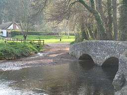 |
River Avill | Possibly 15th-century; two round arches. Grade I listed,[128] Scheduled Ancient Monument. Carries public bridleway. |
| Somerset | Ilchester 51°00′28″N 2°42′50″W / 51.0077°N 2.7140°W |
Pill Bridge1 |  |
River Ivel | 17th-century; three semicircular arches. Grade II listed,[129] Scheduled Ancient Monument.[130] Carries public bridleway. |
| Somerset | Horner 51°11′55″N 3°34′47″W / 51.1985°N 3.5797°W |
Hacketty Way Bridge1 | 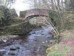 |
River Horner | Late medieval; single-span. Grade II* listed,[131] Scheduled Ancient Monument.[132] Carries public bridleway. |
| Somerset | West Luccombe 51°12′13″N 3°34′40″W / 51.2035°N 3.5777°W |
West Luccombe packhorse bridge |  |
River Horner | Late medieval; single-span. Grade II* listed,[133] Scheduled Ancient Monument.[134] Carries public footpath. |
| Somerset | Oare 51°12′57″N 3°43′52″W / 51.2159°N 3.7310°W |
Malmsmead Bridge |  |
Badgworthy Water | 17th–18th-century; two rounded arches. Grade II listed.[135] Carries public road. |
| Somerset | Oare 51°12′18″N 3°41′25″W / 51.2050°N 3.6904°W |
Robber's Bridge | Weir Water | Carries public road. | |
| Somerset | Queen Camel 51°01′22″N 2°34′48″W / 51.0229°N 2.5799°W |
packhorse bridge1 | River Cam | Carries public footpath. | |
| Somerset | Rode 51°17′03″N 2°17′25″W / 51.2842°N 2.2903°W |
Scutt's Bridge1 |  |
River Frome | Three semicircular arches. Grade II listed.[136] Carries public footpath. |
| Somerset | Tellisford 51°17′59″N 2°16′48″W / 51.2996°N 2.2799°W |
Tellisford Bridge2 | River Frome | Three semicircular arches. Grade II listed.[137] Carries public footpath. | |
| Somerset | Watchet 51°10′28″N 3°20′55″W / 51.1745°N 3.3486°W |
Kentsford Bridge1 | Washford River | Probably late medieval; two segmental arches. Grade II listed.[138] Carries public footpath. | |
| Somerset | Wellow 51°19′17″N 2°22′21″W / 51.3213°N 2.3725°W |
Wellow Bridge | 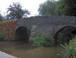 |
Wellow Brook | Late medieval; two round arches. Grade II listed.[139] Carries public footpath. |
| Somerset | Winsford 51°07′31″N 3°37′12″W / 51.1254°N 3.6201°W |
Lyncombe Bridge | River Exe | 17th- or 18th-century, possibly earlier. Grade II listed.[140] | |
| Somerset | Winsford 51°06′19″N 3°33′52″W / 51.1053°N 3.5644°W |
Old Vicarage Bridge1 |  |
River Exe | Medieval, restored 1952; two semicircular arches. Grade II listed.[141] Carries public footpath, just upstream of 19th-century road bridge (also called Vicarage Bridge). |
| Somerset | Winsford 51°06′10″N 3°33′53″W / 51.1027°N 3.5646°W |
packhorse bridge1 |  |
Winn Brook | Medieval, restored 1952; single semicircular arch. Grade II listed.[142] |
| South Yorkshire | Longshaw 53°19′45″N 1°36′21″W / 53.3291°N 1.6059°W |
Burbage Brook Bridge1 |  |
Burbage Brook | c. 1750; single segmental arch. Grade II listed.[143] On open access moorland, near to Carl Wark. |
| South Yorkshire | Oxspring 53°31′10″N 1°35′55″W / 53.5195°N 1.5986°W |
Willow Bridge1 | 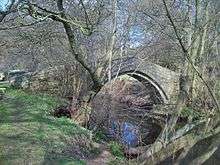 |
River Don | Probably 17th-century; single slightly pointed arch. Grade II listed.[144] On public bridleway, part of the Trans-Pennine Trail. |
| South Yorkshire | Rivelin Valley 53°22′53″N 1°33′44″W / 53.3814°N 1.5622°W |
packhorse bridge1 |  |
River Rivelin | c. 1775; single elliptical arch. Grade II listed.[145] In Country Park. |
| South Yorkshire | Wharncliffe Side 53°26′42″N 1°33′41″W / 53.4449°N 1.5615°W |
Glen Howe Packhorse Bridge2 |  |
Tinker Brook | Formerly New Mill Bridge. 1734; single elliptical arch. Grade II listed.[146] In public park; resited during construction of Ewden Reservoir. |
| Staffordshire | Great Haywood 52°48′02″N 2°00′31″W / 52.8006°N 2.0086°W |
Essex Bridge1 |  |
River Trent | Probably 16th-century; fourteen round arches. Described as "perhaps the least altered old bridge in the county"[147] and "the longest packhorse bridge in the country".[2]:129 Grade I listed,[147] Scheduled Ancient Monument.[148] Carries public bridleway. |
| Staffordshire | Tamworth 52°37′52″N 1°41′20″W / 52.631°N 1.689°W |
The Old Bolebridge | River Anker | No longer extant; demolished c.1878–79.[149] | |
| Suffolk | Cavenham 52°17′45″N 0°35′19″E / 52.2958°N 0.5886°E |
Stone Bridge2 |  |
tributary of River Lark | Probably 16th-century; single segmental brick arch. Grade II listed.[150] Adjacent to public road. |
| Suffolk | Moulton 52°15′10″N 0°29′08″E / 52.2528°N 0.4855°E |
Moulton Packhorse Bridge1 | River Kennett | ca. 1446[151] with 18th-century alterations;[4] four pointed arches. Grade II* listed,[152] Scheduled Ancient Monument.[153] Carries public footpath. | |
| Surrey | Ewell 51°21′35″N 0°15′49″W / 51.3596°N 0.2637°W |
The Packhorse Bridge |  |
Hogsmill River | 18th-century; single semicircular brick arch. Grade II listed.[154] |
| Surrey | Gomshall 51°13′14″N 0°26′56″W / 51.2206°N 0.4490°W |
River Tillingbourne | 15th-century; three arches. Grade II listed.[155] | ||
| Warwickshire | Shustoke 52°30′59″N 1°41′25″W / 52.5165°N 1.6904°W |
Blyth Hall Packhorse Bridge | River Blythe | 18th-century; three semicircular arches. Grade II listed.[156] | |
| West Midlands | Hampton-in-Arden 52°25′07″N 1°41′16″W / 52.4186°N 1.6878°W |
Hampton-in-Arden packhorse bridge2 |  |
River Blythe | 15th-century; three stone and two brick arches. Grade II* listed,[157] Scheduled Ancient Monument.[158] |
| West Yorkshire | Bingley 53°50′32″N 1°50′30″W / 53.8422°N 1.8418°W |
Beckfoot Bridge1 |  |
Harden Beck | c.1723; single-span. Grade II listed.[159] Carries public footpath. |
| West Yorkshire | Clayton West 53°36′04″N 1°36′27″W / 53.6010°N 1.6074°W |
Park Mill Bridge1 |  |
River Dearne | Probably 18th-century; single-span. Grade II listed.[160] Carries public right-of-way. |
| West Yorkshire | Colden 53°45′11″N 2°03′48″W / 53.7531°N 2.0633°W |
Strines Bridge1 |  |
Colden Water | Possibly 17th-century; single segmental arch. Grade II listed.[161] Carries public footpath; contra Hinchliffe, the English Heritage listing calls it a "fine graceful example of the packhorse type of bridge, but which having steps was probably only ever used as a foot-bridge...."[162] |
| West Yorkshire | Goose Eye 53°51′38″N 1°58′24″W / 53.8605°N 1.9734°W |
 |
Dean Beck | Date unknown; single arch. Grade II listed.[163] Adjacent to clapper bridge; carries public bridleway. | |
| West Yorkshire | Haworth 53°50′03″N 1°58′13″W / 53.8343°N 1.9704°W |
Long Bridge1 |  |
River Worth | Date uncertain; single-span. Grade II listed.[164] Carries public footpath. |
| West Yorkshire | Hebden Bridge 53°44′31″N 2°00′48″W / 53.7420°N 2.0133°W |
The Old Bridge2 | Hebden Water | Also known as Hepton Brig.[2]:93 c.1510; three segmental arches. Grade II* listed.[165] Carries public right-of-way. | |
| West Yorkshire | Loxley 53°24′05″N 1°33′02″W / 53.4015°N 1.5505°W |
River Loxley | Probably 18th-century, restored 1864. Grade II listed.[166] | ||
| West Yorkshire | Marsden 53°36′20″N 1°57′29″W / 53.6055°N 1.9580°W |
Close Gate Bridge1 |  |
Haigh Clough | 17th- or 18th-century; single-span. Grade II* listed.[167] |
| West Yorkshire | Marsden 53°36′06″N 1°55′49″W / 53.6017°N 1.9304°W |
Mellor Bridge1 |  |
River Colne | 17th- or 18th-century; single-span. Grade II* listed.[168] Carries public footpath. |
| West Yorkshire | Meanwood 53°49′16″N 1°33′41″W / 53.8212°N 1.5613°W |
Meanwood Beck | Early 18th-century. Grade II listed, "a rare survival of a pack-horse bridge sited within a suburban setting".[169] | ||
| West Yorkshire | Oxenhope 53°49′12″N 1°56′47″W / 53.8201°N 1.9465°W |
North Ives or Donkey Bridge1 |  |
Bridgehouse Beck | Date uncertain; single steeply arched span. Grade II listed.[170] Carries public footpath. |
| West Yorkshire | Rishworth Moor 53°38′20″N 1°59′38″W / 53.6389°N 1.9938°W |
Oxygrains Old Bridge2 |  |
Oxygrains Clough | Probably early 17th-century;[171] single-span. Scheduled Ancient Monument.[172] On Access Land. |
| West Yorkshire | Ripponden 53°40′28″N 1°56′24″W / 53.6745°N 1.9399°W |
Waterloo or Ripponden Old Bridge2 |  |
River Ryburn | 1752;[173] single-span. Grade II* listed,[174] Scheduled Ancient Monument.[175] Public road. |
| West Yorkshire | Stanbury 53°50′03″N 1°58′42″W / 53.8342°N 1.9784°W |
Lumbfoot Bridge1 |  |
River Worth | Date uncertain; single-span. Grade II listed.[176] Carries public footpath. |
| West Yorkshire | Wakefield 53°40′33″N 1°29′22″W / 53.6759°N 1.4895°W |
Little Bridge1 |  |
River Calder | Probably 18th-century; three elliptical arches. Grade II listed.[177] |
| West Yorkshire | Wadsworth 53°46′45″N 2°00′47″W / 53.7791°N 2.0130°W |
Lumb Bridge1 |  |
Crimsworth Dean Beck | Probably early 18th-century; single-span. Grade II listed.[178] Carries public bridleway. |
| Wiltshire | Coombe Bissett 51°02′12″N 1°50′46″W / 51.0368°N 1.8461°W |
packhorse bridge2 |  |
River Ebble | Medieval, widened in the 19th century; three low two-centred arches. Grade II listed.[179] Carries public footpath. |
| Wiltshire | Melksham 51°21′28″N 2°10′15″W / 51.3577°N 2.1708°W |
packhorse bridge1 | River Avon | 1725; four segmental arches. Grade II listed.[180] Carries public footpath. | |
| Worcestershire | Astley 52°18′10″N 2°18′40″W / 52.3028°N 2.3112°W |
New Bridge | Dick Brook | Late 18th- or early 19th-century, possibly earlier, single arch. Grade II listed.[181] Carries public bridleway. | |
| Worcestershire | Shell 52°14′07″N 2°04′22″W / 52.2352°N 2.0729°W |
Shell Packhorse Bridge1 |  |
Bow Brook | 17th-century or earlier, two round arches. Grade II listed.[182] Adjacent to ford on public road. |
Isle of Man
| County | Location | Name | Photograph | Crosses | Notes |
|---|---|---|---|---|---|
| Isle of Man | Ballasalla 54°06′07″N 4°37′53″W / 54.1020°N 4.6313°W |
Crossag or Monks' Bridge |  |
Silver Burn | c. 1350; two slightly pointed arches. "It is believed to be the best example of [a] medieval bridge in the British Isles."[183] |
Scotland
| County | Location | Name | Photograph | Crosses | Notes |
|---|---|---|---|---|---|
| Borders | Stow of Wedale 55°41′24″N 2°51′46″W / 55.69°N 2.8629°W |
Luggate Water Bridge |  |
Gala Water | c.1790; three segmental arches. Grade B listed.[184] |
| Fife | Coaltown of Balgonie 56°10′21″N 3°07′00″W / 56.1726°N 3.1166°W |
Barrel Brig | River Ore, Fife | Early 18th century; double-span with cutwaters. Grade B listed, Scheduled Ancient Monument.[185][186] | |
| Highland | Carrbridge 57°17′02″N 3°48′57″W / 57.2838°N 3.8158°W |
Carr Bridge |  |
River Dulnain | 1717; single-span. Grade B listed,[187] Scheduled Ancient Monument.[188] |
| Highland | John o' Groats 58°38′35″N 3°05′07″W / 58.6430°N 3.0853°W |
 |
Huna Burn | 1651; single-span. Grade B listed.[189] | |
| South Lanarkshire | East Kilbride 55°43′46″N 4°13′38″W / 55.7295°N 4.2271°W |
Craig Mill Packhorse Bridge | White Cart Water | Single-span. Grade B listed.[190] |
Wales
| County | Location | Name | Photograph | Crosses | Notes |
|---|---|---|---|---|---|
| Blaenau Gwent | Aberbeeg 51°42′36″N 3°08′39″W / 51.7101°N 3.1442°W |
Ebbw Fach River | Grade II listed.[191] | ||
| Conwy | Penmachno 53°03′36″N 3°46′51″W / 53.0599°N 3.7807°W |
Roman Bridge | River Machno | Grade II listed.[192] | |
| Flintshire | Caergwrle 53°06′39″N 3°02′12″W / 53.1109°N 3.0367°W |
Caergwrle Packhorse Bridge |  |
River Alyn | Mid-17th-century; "one of the finest examples in Wales".[193] Grade II listed.[194] |
| Flintshire | Ffrith 53°05′24″N 3°03′57″W / 53.0901°N 3.0657°W |
Ffrith Bridge |  |
River Cegidog | Probably 18th-century; single-span. Grade II listed, Scheduled Ancient Monument.[195] |
| Gwynedd | Dyffryn Ardudwy 52°47′31″N 4°01′31″W / 52.7919°N 4.0253°W |
Pont Scethin |  |
River Ysgethin | Probably 18th-century; single arch. Scheduled Ancient Monument.[196] |
| Gwynedd | Minllyn 52°42′25″N 3°41′46″W / 52.7070°N 3.6961°W |
Pont Minllyn |  |
River Dovey | Probably 17th-century; two segmental arches. Grade II listed,[197] Scheduled Ancient Monument.[198] |
| Powys | Llangenny 51°51′49″N 3°06′24″W / 51.8636°N 3.1067°W |
 |
Grwyne Fawr | Grade II listed.[199] | |
| Swansea | Cheriton 51°36′40″N 4°13′34″W / 51.6111°N 4.2262°W |
Kittlehill Packhorse Bridge |  |
Burry Pill | Grade II listed.[200] |
| Wikimedia Commons has media related to Packhorse bridges. |
References
- 1 2 "Packhorse Cargo". cottontown.org. Retrieved January 9, 2007.
- 1 2 3 4 5 6 7 8 9 10 11 12 13 14 15 16 Hinchliffe, Ernest (1994). A Guide to the Packhorse Bridges of England. Milnrow, Cumbria: Cicerone Press. ISBN 1-85284-143-5.
- ↑ Maxwell G. Lay, Ways of the World: A History of the World's Roads (Rutgers University Press) 1992:23–25; 96.
- 1 2 "History and Research Moulton Packhorse Bridge". English Heritage. Retrieved 4 November 2012.
- ↑ "Packhorse Bridge, Sutton". britishlistedbuildings.co.uk. Retrieved 5 November 2012.
- ↑ "Sutton Packhorse Bridge". ancientmonuments.info. Retrieved 5 November 2012.
- 1 2 "Central and Easternmost Packhorse Bridges and Adjoining Causeway, Hockenhull". britishlistedbuildings.co.uk. Retrieved 6 November 2012.
- 1 2 Jervoise, E. (1931). The Ancient Bridges of the North of England. Architectural Press.
- ↑ "Westernmost of the 3 Packhorse Bridges, Hockenhull". britishlistedbuildings.co.uk. Retrieved 6 November 2012.
- ↑ "The Packhorse Bridge, Styal". britishlistedbuildings.co.uk. Retrieved 19 November 2012.
- ↑ "Three Shire Heads Bridge, Quarnford". britishlistedbuildings.co.uk. Retrieved 6 November 2012.
- ↑ "Footbridge and Pack Horse Bridge 200 Metres to South East of Bowithick, Altarnun". britishlistedbuildings.co.uk. Retrieved 19 November 2012.
- ↑ Historic England. "The West Bridge (Grade I) (1196031)". National Heritage List for England. Retrieved 5 October 2015.
- ↑ "High Sweden Bridge, Lakes". britishlistedbuildings.co.uk. Retrieved 13 November 2012.
- ↑ "High Beckfoot Bridge, Barbon". britishlistedbuildings.co.uk. Retrieved 12 November 2012.
- ↑ "Packhorse Bridge North of Calva Hall, Dean". britishlistedbuildings.co.uk. Retrieved 13 November 2012.
- ↑ "Drigg Holme packhorse bridge". ancientmonuments.info. Retrieved 5 November 2012.
- ↑ "Doctor Bridge, Eskdale". ancientmonuments.info. Retrieved 13 November 2012.
- ↑ "Packhorse Bridge over Rais Beck Circa 120 Yards North East of Fawcett Mill, Orton". britishlistedbuildings.co.uk. Retrieved 13 November 2012.
- ↑ "Packhorse Bridge to North East of Knock Pike, Long Marton". britishlistedbuildings.co.uk. Retrieved 19 November 2012.
- ↑ "Slaters Bridge (That Part in the Lakes Urban District), Lakes". britishlistedbuildings.co.uk. Retrieved 13 November 2012.
- ↑ "Packhorse Bridge to West of Lowgill Viaduct, Firbank". ancientmonuments.info. Retrieved 19 November 2012.
- ↑ "Devils Bridge, Pennington". ancientmonuments.info. Retrieved 13 November 2012.
- ↑ "Stockley Bridge, Borrowdale". britishlistedbuildings.co.uk. Retrieved 4 November 2012.
- ↑ "Parish Crag Bridge over Swindale Beck, Shap Rural". britishlistedbuildings.co.uk. Retrieved 6 November 2012.
- ↑ "Park Bridge". Old Cumbria Gazetteer. Retrieved 7 November 2012.
- ↑ "Pack Horse Bridge over Stainton Beck, Stainton". britishlistedbuildings.co.uk. Retrieved 13 November 2012.
- ↑ "Row Bridge North of Hotel, Wasdale". britishlistedbuildings.co.uk. Retrieved 13 November 2012.
- ↑ "Watendlath Packhorse Bridge, Borrowdale". britishlistedbuildings.co.uk. Retrieved 13 November 2012.
- ↑ "Monks Bridge over River Calder to South East of Farthwaite Farmhouse, Ennerdale and Kinniside". britishlistedbuildings.co.uk. Retrieved 13 November 2012.
- ↑ "Pack Horse Bridge Beside A5074 a Quarter of a Mile North West of High Mill House, Crook". britishlistedbuildings.co.uk. Retrieved 19 November 2012.
- ↑ "Winster Bridge (That Part in Cartmel), Cartmel Fell". britishlistedbuildings.co.uk. Retrieved 13 November 2012.
- ↑ "Sheepwash Bridge, Ashford in the Water". britishlistedbuildings.co.uk. Retrieved 4 November 2012.
- ↑ "Holme Bridge, Bakewell". britishlistedbuildings.co.uk. Retrieved 6 November 2012.
- ↑ "Holm (sic) Bridge". ancientmonuments.info. Retrieved 5 November 2012.
- ↑ "Gibralter (sic) Bridge, Edale". britishlistedbuildings.co.uk. Retrieved 6 November 2012.
- ↑ "Packhorse Bridge at Foot of Jacobs Ladder, Edale". britishlistedbuildings.co.uk. Retrieved 6 November 2012.
- ↑ "Old Packhorse Bridge, Hayfield". britishlistedbuildings.co.uk. Retrieved 4 November 2012.
- ↑ "Packhorse Bridge, Hartington Upper Quarter". britishlistedbuildings.co.uk. Retrieved 4 November 2012.
- ↑ "Packhorse Bridge, Bradfield". britishlistedbuildings.co.uk. Retrieved 4 November 2012.
- ↑ "Reconstructed packhorse bridge from Derwent Hall". ancientmonuments.info. Retrieved 4 November 2012.
- ↑ "Packhorse Bridge at OS 197512, Tissington and Lea Hall". britishlistedbuildings.co.uk. Retrieved 19 November 2012.
- ↑ "Viators Bridge, Alstonefield". britishlistedbuildings.co.uk. Retrieved 6 November 2012.
- ↑ "Packhorse Bridge over River Bradford 120 Metres South East of Braemar House, Harthill". britishlistedbuildings.co.uk. Retrieved 19 November 2012.
- ↑ "Coal Pit Bridge over the River Lathkill, Youlgreave". britishlistedbuildings.co.uk. Retrieved 17 November 2012.
- ↑ "Packhorse Bridge Approximately 30 Metres to West of Leeford Bridge (That Part in Brendon CP), Brendon". britishlistedbuildings.co.uk. Retrieved 8 November 2012.
- ↑ Historic England. "Fingle Bridge (1146775)". National Heritage List for England. Retrieved 4 March 2013.
- ↑ "Beckford Bridge, Dalwood". britishlistedbuildings.co.uk. Retrieved 4 November 2012.
- ↑ "Beckford Bridge". ancientmonuments.info. Retrieved 7 November 2012.
- ↑ "Bridge, Sidmouth". britishlistedbuildings.co.uk. Retrieved 4 November 2012.
- ↑ "Packhorse Bridge Approximately 20 Metres west of Westcott Barton, Marwood, Devon". britishlistedbuildings.co.uk. Retrieved 19 November 2012.
- ↑ "Sharford Footbridge". ancientmonuments.info. Retrieved 17 November 2012.
- ↑ "Footbridge over the River Divelish, Fifehead Neville". britishlistedbuildings.co.uk. Retrieved 8 November 2012.
- ↑ "Packhorse Bridge Approximately 35m South of Ryall's Farmhouse., Gussage St Michael". britishlistedbuildings.co.uk. Retrieved 8 November 2012.
- ↑ "Bridge 60 Metres North of St Laurence's Church Bridge". britishlistedbuildings.co.uk. Retrieved 17 November 2012.
- ↑ "Bridge 55 Metres North North East of the Manor House, Rampisham". britishlistedbuildings.co.uk. Retrieved 17 November 2012.
- ↑ "Footbridge over the River Winterbourne, 200 Metres West of King Street, Sturminster Marshall". britishlistedbuildings.co.uk. Retrieved 17 November 2012.
- ↑ "Footbridge over the River Tarrant of Monkton Ford, Tarrant Monkton". britishlistedbuildings.co.uk. Retrieved 8 November 2012.
- ↑ "Nabb Bridge, 160 Metres West of Nabb House, Bowes". britishlistedbuildings.co.uk. Retrieved 13 November 2012.
- ↑ "Ketton Packhorse Bridge, Whessoe". britishlistedbuildings.co.uk. Retrieved 14 November 2012.
- ↑ "Packhorse Bridge over Pan Burn South of Low Mill Farm, Cornsay". britishlistedbuildings.co.uk. Retrieved 19 November 2012.
- ↑ "Bow Bridge or Thorsgill Beck Packhorse Bridge, Westwick". britishlistedbuildings.co.uk. Retrieved 19 November 2012.
- ↑ "Pack-Horse Bridge, Headlam". britishlistedbuildings.co.uk. Retrieved 14 November 2012.
- ↑ "The Packhorse Bridge between Kelvedon and Feering". Retrieved 5 November 2012.
- ↑ "Packhorse Bridge over Knee Brook, Todenham". britishlistedbuildings.co.uk. Retrieved 17 November 2012.
- ↑ "Sturt Bridge at National Grid Reference ST 7313 8812, Hawkesbury". britishlistedbuildings.co.uk. Retrieved 17 November 2012.
- ↑ "Prestolee Bridge over River Irwell, Bolton". britishlistedbuildings.co.uk. Retrieved 14 November 2012.
- ↑ "Roman Bridge, Stockport". britishlistedbuildings.co.uk. Retrieved 17 November 2012.
- ↑ Historic England. "Roman Bridge (Grade II) (1242214)". National Heritage List for England. Retrieved 11 February 2015.
- ↑ "Highways Heritage Walks: By Turnpike and Towpath in Saddleworth". Milestone Society. Retrieved 26 August 2013.
- ↑ Historic England. "Brownhill Bridge Mill (Grade II) (1309426)". National Heritage List for England. Retrieved 26 August 2013.
- ↑ "Eynsford Bridge, Eynsford". britishlistedbuildings.co.uk. Retrieved 4 November 2012.
- ↑ "Higherford Old Bridge, Barrowford". britishlistedbuildings.co.uk. Retrieved 8 November 2012.
- ↑ "Higherford Old Bridge". ancientmonuments.info. Retrieved 8 November 2012.
- ↑ "Packhorse Bridge at SD 884 362, Nelson". britishlistedbuildings.co.uk. Retrieved 8 November 2012.
- ↑ "Packhorse Bridge, 130 Metres Downstream from Keer Bridge (Aqueduct) by Mill House, Borwick". britishlistedbuildings.co.uk. Retrieved 19 November 2012.
- ↑ "Pack Horse Bridge, Trawden Forest". britishlistedbuildings.co.uk. Retrieved 6 November 2012.
- ↑ "Wycoller packhorse bridge". ancientmonuments.info. Retrieved 6 November 2012.
- ↑ "Pack Horse Bridge, Anstey". britishlistedbuildings.co.uk. Retrieved 4 November 2012.
- ↑ "Packhorse bridge". ancientmonuments.info. 1 June 1966. Retrieved 17 November 2012.
- ↑ "King William's Bridge, Anstey". britishlistedbuildings.co.uk. Retrieved 4 November 2012.
- ↑ "Aylestone Old Bridge, Leicester". britishlistedbuildings.co.uk. Retrieved 8 November 2012.
- ↑ "The 'Roman' bridge, Aylestone". ancientmonuments.info. Retrieved 7 November 2012.
- ↑ "Bridge at Medbourne". ancientmonuments.info. Retrieved 17 November 2012.
- ↑ "Bridge, Rearsby". britishlistedbuildings.co.uk. Retrieved 17 November 2012.
- ↑ "Sandham Bridge, Thurcaston and Cropston". britishlistedbuildings.co.uk. Retrieved 17 November 2012.
- ↑ "Coffin Bridge, Thurcaston and Cropston". britishlistedbuildings.co.uk. Retrieved 17 November 2012.
- ↑ "Bridge Near Sandham Bridge, Thurcaston and Cropston". britishlistedbuildings.co.uk. Retrieved 17 November 2012.
- ↑ "Packhorse Bridge, Utterby". britishlistedbuildings.co.uk. Retrieved 17 November 2012.
- ↑ "Packhorse Bridge over River Rasen, West Rasen". britishlistedbuildings.co.uk. Retrieved 7 November 2012.
- ↑ "Packhorse bridge". ancientmonuments.info. Retrieved 7 November 2012.
- ↑ "Pack Horse Bridge North East of the Abbey in Abbey Grounds, Walsingham". britishlistedbuildings.co.uk. Retrieved 17 November 2012.
- ↑ "Packhorse Bridge over River Cherwell, Charwelton". britishlistedbuildings.co.uk. Retrieved 4 November 2012.
- ↑ "Charwelton Bridge, Northamptonshire". ancientmonuments.info. Retrieved 4 November 2012.
- ↑ "Footbridge, Ovingham". britishlistedbuildings.co.uk. Retrieved 14 November 2012.
- ↑ "Packhorse Bridge over Aldbrough Beck, Aldbrough". britishlistedbuildings.co.uk. Retrieved 14 November 2012.
- ↑ "New Bridge, Birstwith". britishlistedbuildings.co.uk. Retrieved 4 November 2012.
- ↑ "Brokken Bridge, Clapham cum Newby". britishlistedbuildings.co.uk. Retrieved 14 November 2012.
- ↑ "Clow Beck Pack Horse Bridge, Near Monk End Farm, Croft-on-Tees". britishlistedbuildings.co.uk. Retrieved 14 November 2012.
- ↑ "Beggars Bridge, Glaisdale". britishlistedbuildings.co.uk. Retrieved 4 November 2012.
- ↑ "Cockhill Packhorse Bridge, Hampsthwaite". britishlistedbuildings.co.uk. Retrieved 14 November 2012.
- ↑ "Ivelet Bridge, Muker". britishlistedbuildings.co.uk. Retrieved 15 November 2012.
- ↑ "Spruisty Bridge, Harrogate". britishlistedbuildings.co.uk. Retrieved 15 November 2012.
- ↑ "Bridge at Ford over Linton Beck, Linton". britishlistedbuildings.co.uk. Retrieved 8 November 2012.
- ↑ "Dob Park Bridge, Norwood". britishlistedbuildings.co.uk. Retrieved 14 November 2012.
- ↑ "Ings Bridge, Pickering". britishlistedbuildings.co.uk. Retrieved 16 November 2012.
- ↑ "Bridge Between Ravenseat Farmhouse and Ravenseat Cottage, Muker". britishlistedbuildings.co.uk. Retrieved 16 November 2012.
- ↑ "Packhorse Bridge, Romanby". britishlistedbuildings.co.uk. Retrieved 8 November 2012.
- ↑ "Pack-Horse Bridge over Wilderness Beck, Skipton". britishlistedbuildings.co.uk. Retrieved 16 November 2012.
- ↑ "Town End Bridge, Sowerby". britishlistedbuildings.co.uk. Retrieved 16 November 2012.
- ↑ "Packhorse Bridge Approximately 1 Metre to West of Old Corn Mill, Spofforth with Stockeld". britishlistedbuildings.co.uk. Retrieved 19 November 2012.
- ↑ "Pack Horse Bridge, Stokesley". britishlistedbuildings.co.uk. Retrieved 16 November 2012.
- ↑ "Thornthwaite Packhorse Bridge, 140m North East of Church House". ancientmonuments.info. Retrieved 16 November 2012.
- ↑ "Hunter's Sty Bridge". ancientmonuments.info. Retrieved 16 November 2012.
- ↑ "The Bridge, Buckden (sic)". britishlistedbuildings.co.uk. Retrieved 16 November 2012.
- ↑ "Packhorse Bridge Redhill Lock, Ratcliffe on Soar". britishlistedbuildings.co.uk. Retrieved 19 November 2012.
- ↑ "Clun Bridge, Clun". britishlistedbuildings.co.uk. Retrieved 4 November 2012.
- ↑ "Packhorse Bridge, Rushbury". britishlistedbuildings.co.uk. Retrieved 17 November 2012.
- ↑ "Packhorse Bridge at NGR SS 9051 4691, Selworthy". britishlistedbuildings.co.uk. Retrieved 7 November 2012.
- ↑ "Allerford Packhorse Bridge, Immediately North of Cross Lane Farm". ancientmonuments.info. Retrieved 7 November 2012.
- ↑ "Bow Bridge, Bruton". britishlistedbuildings.co.uk. Retrieved 7 November 2012.
- ↑ "The Packhorse Bridge 100m North West of the Church of St Mary". ancientmonuments.info. Retrieved 7 November 2012.
- ↑ "Packhorse Bridge on Roadside at NGR ST 4983 5571, Priddy". britishlistedbuildings.co.uk. Retrieved 7 November 2012.
- ↑ "Chewton Pack Horse Bridge at St 654 664 to East of Chewton Keynsham, Keynsham". britishlistedbuildings.co.uk. Retrieved 19 November 2012.
- ↑ "Chewton Keynsham packhorse bridge". ancientmonuments.info. Retrieved 19 November 2012.
- ↑ "Watching Brief and Recording (1994–97), Dowlish Wake Packhorse Bridge, Dowlish Wake". 11 October 2004. Retrieved 8 November 2012.
- ↑ "Packhorse Bridge, Dowlish Wake". britishlistedbuildings.co.uk. Retrieved 8 November 2012.
- ↑ "Gallox Bridge, Dunster". britishlistedbuildings.co.uk. Retrieved 4 November 2012.
- ↑ "Pill Bridge, Long Sutton". britishlistedbuildings.co.uk. Retrieved 17 November 2012.
- ↑ "Pill Bridge". ancientmonuments.info. Retrieved 17 November 2012.
- ↑ "Packhorse Bridge at NGR SS 8974 4554, Luccombe". britishlistedbuildings.co.uk. Retrieved 4 November 2012.
- ↑ "Horner packhorse bridge". ancientmonuments.info. Retrieved 4 November 2012.
- ↑ "Packhorse Bridge at NGR SS 8987 4608, Luccombe". britishlistedbuildings.co.uk. Retrieved 5 November 2012.
- ↑ "West Luccombe packhorse bridge". ancientmonuments.info. Retrieved 4 November 2012.
- ↑ "Malsmead Bridge at NGR SS 7919 4770, Oare". britishlistedbuildings.co.uk. Retrieved 5 November 2012.
- ↑ "Scutt's Bridge over River Frome at NGR ST 7985 5394, Tellisford". britishlistedbuildings.co.uk. Retrieved 17 November 2012.
- ↑ "Bridge over River Frome at NGR ST 8058 5565, Tellisford". britishlistedbuildings.co.uk. Retrieved 17 November 2012.
- ↑ "Bridge, About 50 Metres South West of Kentsford Farmhouse, Williton". britishlistedbuildings.co.uk. Retrieved 17 November 2012.
- ↑ "Wellow Bridge, Wellow". britishlistedbuildings.co.uk. Retrieved 5 November 2012.
- ↑ "Packhorse Bridge at NGR SS 8670 3748, About 50 Metres West of Lyncombe, Winsford". britishlistedbuildings.co.uk. Retrieved 17 November 2012.
- ↑ "Packhorse Bridge over River Exe at NGR SS 9057 3516, Winsford". britishlistedbuildings.co.uk. Retrieved 17 November 2012.
- ↑ "Packhorse Bridge over Winn Brook at NGR SS 9055 3488, Winsford". britishlistedbuildings.co.uk. Retrieved 17 November 2012.
- ↑ "Packhorse Bridge Approximately 850 Metres North of Burbage Brook, Sheffield". britishlistedbuildings.co.uk. Retrieved 16 November 2012.
- ↑ "Willow Bridge, Approximately 300 Metres North of Willow Lane Bungalow, Oxspring". britishlistedbuildings.co.uk. Retrieved 16 November 2012.
- ↑ "Packhorse Bridge 70 Metyres (sic) East of Rails Road Bridge, Sheffield". britishlistedbuildings.co.uk. Retrieved 17 November 2012.
- ↑ "Glen Howe Packhorse Bridge, Approximately 100 Metres Upstream of Cottage, Bradfield". britishlistedbuildings.co.uk. Retrieved 19 November 2012.
- 1 2 "Essex Bridge, Colwich". britishlistedbuildings.co.uk. Retrieved 4 November 2012.
- ↑ "Essex Bridge, Great Haywood". ancientmonuments.info. Retrieved 5 November 2012.
- ↑ "Old Bolebridge, Bolebridge, Tamworth". Staffordshire County Council. Retrieved 6 November 2012.
- ↑ "Packhorse Bridge, Known As Stone Bridge, Cavenham". britishlistedbuildings.co.uk. Retrieved 19 November 2012.
- ↑ "Moulton Suffolk – Moulton Village Website". Moulton Village Website. Moulton, Suffolk. Archived from the original on November 9, 2012. Retrieved 9 November 2012.
Further along the river you can find the Pack Horse Bridge which was built about 1446 and formed part of the trade route from Bury St Edmunds to Cambridge.
- ↑ "Pack Horse Bridge over the River Kennet, Moulton". britishlistedbuildings.co.uk. Retrieved 4 November 2012.
- ↑ "Packhorse bridge". ancientmonuments.info. Retrieved 5 November 2012.
- ↑ "Packhorse Bridge at Ewell Court, Epsom and Ewell". britishlistedbuildings.co.uk. Retrieved 19 November 2012.
- ↑ "Packhorse Bridge to Rear of Gomshall Tanneries, Shere". britishlistedbuildings.co.uk. Retrieved 19 November 2012.
- ↑ "Blyth Hall Packhorse Bridge over River Blyth, Shustoke". britishlistedbuildings.co.uk. Retrieved 19 November 2012.
- ↑ "Packhorse Bridge over River Blythe, Hampton in Arden". britishlistedbuildings.co.uk. Retrieved 7 November 2012.
- ↑ "Packhorse bridge". ancientmonuments.info. Retrieved 5 November 2012.
- ↑ "Bridge Approximately 15 Metres North of Beckfoot Farmhouse, Bradford". britishlistedbuildings.co.uk. Retrieved 4 November 2012.
- ↑ "Packhorse Bridge, Denby Dale". britishlistedbuildings.co.uk. Retrieved 8 November 2012.
- ↑ "Strines Bridge, Blackshaw". britishlistedbuildings.co.uk. Retrieved 17 November 2012.
- ↑ Historic England. "Strines Bridge (Grade II) (1133947)". National Heritage List for England. Retrieved 15 May 2016.
- ↑ "Packhorse Bridge over Dean Beck, Keighley". britishlistedbuildings.co.uk. Retrieved 8 November 2012.
- ↑ "Long Bridge, Haworth, Cross Roads and Stanbury". britishlistedbuildings.co.uk. Retrieved 17 November 2012.
- ↑ "The Old Bridge over the Hebden Water, Hebden Royd". britishlistedbuildings.co.uk. Retrieved 8 November 2012.
- ↑ "Packhorse Bridge over River Loxley at Croft House, Bradfield". British Listed Buildings. Retrieved 19 November 2012.
- ↑ "Close Gate Bridge, Kirklees". British Listed Buildings. Retrieved 4 November 2012.
- ↑ "Mellor Bridge, Kirklees". britishlistedbuildings.co.uk. Retrieved 4 November 2012.
- ↑ "Packhorse Bridge over Meanwood Beck at NGR 2898 3619, Leeds". britishlistedbuildings.co.uk. Retrieved 19 November 2012.
- ↑ "North Ives Bridge, Oxenhope". britishlistedbuildings.co.uk. Retrieved 17 November 2012.
- ↑ "Jaggermen's Bridges on Old Trails". Retrieved 6 November 2012.
- ↑ "Oxygrains packhorse bridge, Rishworth". ancientmonuments.info. Retrieved 6 November 2012.
- ↑ "Register of ancient monuments, Reference number 1005805". Calderdale Council. Archived from the original on 11 September 2013. Retrieved 12 May 2016.
This saddlebacked bridge ... dates from 1752
- ↑ Historic England. "Ripponden Old Bridge (Grade II*) (1232463)". National Heritage List for England. Retrieved 12 May 2016.
- ↑ "Ripponden (or Waterloo) Bridge". Historic England. Retrieved 12 May 2016.
This monument is scheduled
- ↑ "Packhorse Bridge, Keighley". britishlistedbuildings.co.uk. Retrieved 17 November 2012.
- ↑ "Packhorse Bridge, Wakefield". britishlistedbuildings.co.uk. Retrieved 17 November 2012.
- ↑ "Lumb Bridge, Wadsworth". britishlistedbuildings.co.uk. Retrieved 6 November 2012.
- ↑ "Packhorse Bridge over River Ebble, Coombe Bissett". britishlistedbuildings.co.uk. Retrieved 17 November 2012.
- ↑ "Packhorse Bridge, Melksham Without". ancientmonuments.info. Retrieved 17 November 2012.
- ↑ "Packhorse Bridge on Dick Brook South of Church of St Peter, Astley and Dunley". britishlistedbuildings.co.uk. Retrieved 19 November 2012.
- ↑ "Packhorse Bridge About 100 Yards South of Shell Manor, Himbleton". britishlistedbuildings.co.uk. Retrieved 17 November 2012.
- ↑ "Isle of Man guide: Monks' Bridge". iomguide.com. Retrieved 19 November 2012.
- ↑ "Luggate Water Bridge, Stow". britishlistedbuildings.co.uk. Retrieved 7 November 2012.
- ↑ "Coaltown of Balgonie, Barrel Brig". Historic Environment Scotland. Retrieved 21 March 2016.
- ↑ "Coaltown of Balgonie, Barrel Brig, Thornton". British Listed Buildings. 1 March 1996. Retrieved 21 March 2016.
- ↑ "Carrbridge, Old Bridge over River Dulnain, Duthil And Rothiemurchus". britishlistedbuildings.co.uk. Retrieved 7 November 2012.
- ↑ "Carrbridge, old packhorse bridge". ancientmonuments.info. Retrieved 7 November 2012.
- ↑ "John O'Groat Mills and Mill Bridge over Huna Burn, Canisbay". britishlistedbuildings.co.uk. Retrieved 19 November 2012.
- ↑ "Craig Mill, Packhorse Bridge, and Mill Dam., East Kilbride". britishlistedbuildings.co.uk. Retrieved 17 November 2012.
- ↑ "Aberbeeg 'Packhorse' Bridge, Llanhilleth". britishlistedbuildings.co.uk. Retrieved 19 November 2012.
- ↑ "Roman Bridge, Bro Machno". britishlistedbuildings.co.uk. Retrieved 19 November 2012.
- ↑ "Caergwrle Packhorse Bridge Information Plaque". Retrieved 19 November 2012.
- ↑ "Pack Horse Bridge, Hope". britishlistedbuildings.co.uk. Retrieved 19 November 2012.
- ↑ "CPAT Regional Sites & Monuments Record: PRN 100035 – Ffrith Packhorse bridge". Retrieved 19 November 2012.
- ↑ "Pont Scethin". ancientmonuments.info. Retrieved 19 November 2012.
- ↑ "Pont Minllyn, Mawddwy". britishlistedbuildings.co.uk. Retrieved 19 November 2012.
- ↑ "Pont Minllyn". ancientmonuments.info. Retrieved 19 November 2012.
- ↑ "Packhorse Bridge, The Vale of Grwyney". britishlistedbuildings.co.uk. Retrieved 19 November 2012.
- ↑ "Packhorse Bridge over Burry Pill, Llangennith, Llanmadoc and Cheriton". britishlistedbuildings.co.uk. Retrieved 19 November 2012.