River Cherwell
| Cherwell | |
| River | |
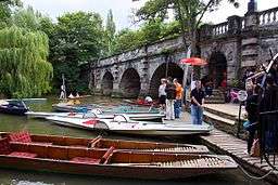 The Cherwell at Magdalen Bridge, Oxford | |
| Country | England |
|---|---|
| Counties | Northamptonshire, Oxfordshire |
| Tributaries | |
| - left | River Swere, River Ray, Bloxham Brook |
| - right | Sor Brook, Mill Lane brook |
| Towns | Banbury |
| Source | |
| - location | Hellidon, Daventry, Northamptonshire |
| - elevation | 179 m (587 ft) |
| - coordinates | 52°12′23″N 1°14′49″W / 52.20639°N 1.24694°W |
| Mouth | River Thames |
| - location | Oxford, Oxfordshire |
| - elevation | 56 m (184 ft) |
| - coordinates | 51°44′32″N 1°14′54″W / 51.74222°N 1.24833°WCoordinates: 51°44′32″N 1°14′54″W / 51.74222°N 1.24833°W |
| Length | 40 mi (64 km) |
| Basin | 943 km2 (364 sq mi) |
| Discharge | for Oxford |
| - average | 7.2 m3/s (254 cu ft/s) |
| Discharge elsewhere (average) | |
| - Enslow Mill | 3.84 m3/s (136 cu ft/s) |
| - Banbury | 1.05 m3/s (37 cu ft/s) |
The River Cherwell (![]() i/ˈtʃɑːrwɛl/ CHAR-well, particularly near Oxford, or /ˈtʃɜːrwɛl/ CHUR-well, particularly in north Oxfordshire)[1][2] is a major tributary of the River Thames in central England.[3] It rises near Hellidon in Northamptonshire and flows south through Oxfordshire for 40 miles (64 km) to meet the Thames at Oxford. It adds a significant discharge to the Thames—when entering Oxford, the Thames's discharge is 17.6 m³/s (622 cu ft/s), but after leaving and consuming the Cherwell it has increased to 24.8 m³/s (876 cu ft/s). The river gives its name to the Cherwell local government district and Cherwell, an Oxford student newspaper.
i/ˈtʃɑːrwɛl/ CHAR-well, particularly near Oxford, or /ˈtʃɜːrwɛl/ CHUR-well, particularly in north Oxfordshire)[1][2] is a major tributary of the River Thames in central England.[3] It rises near Hellidon in Northamptonshire and flows south through Oxfordshire for 40 miles (64 km) to meet the Thames at Oxford. It adds a significant discharge to the Thames—when entering Oxford, the Thames's discharge is 17.6 m³/s (622 cu ft/s), but after leaving and consuming the Cherwell it has increased to 24.8 m³/s (876 cu ft/s). The river gives its name to the Cherwell local government district and Cherwell, an Oxford student newspaper.
Watershed and upper course
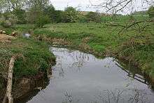
The Cherwell is the northernmost tributary of the Thames.[4] It rises in the ironstone hills at Hellidon, two miles (3 km) west of Charwelton near Daventry. Helidon Hill immediately north of the source forms a watershed: on the south side, the Cherwell feeds the River Thames and thence the North Sea at the Thames Estuary; on the north side, the River Leam feeds the Warwickshire River Avon and the River Severn and thence the Bristol Channel. (A third river system on this watershed rises east of Charwelton and feeds tributary streams of the River Nene and thence the North Sea at The Wash, while the source of the River Great Ouse is also nearby.)
South of Charwelton, the River Cherwell passes between the villages of Hinton and Woodford Halse.
Two miles further on, the River Cherwell swings westward for a few miles, passing below the village of Chipping Warden through Edgcote, site of a Romano-British villa. The river passes from Northamptonshire into Oxfordshire at Hay's Bridge on the A361 Daventry to Banbury road.
In total the river drains an area of 943 square kilometres (364 sq mi).[5]
Cropredy and the Upper Oxford Canal
Half-a-mile north of the village of Cropredy, the River Cherwell turns southward again. The Oxford Canal enters the river valley here and more or less follows the Cherwell on its route to Oxford until it reaches Thrupp near Kidlington. The canal was projected to connect the Coventry Canal to the River Thames, and the Act of Parliament authorising it was passed in 1769. A few years earlier, Oxford merchants had proposed canalising the River Cherwell upstream from their city to Banbury. Construction of the Oxford Canal began near Coventry but the canal didn't reach Banbury until 1778, and it was a further twelve years before it was completed, the first boats reaching Oxford in January 1790.
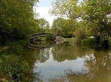
The River Cherwell skirts the east side of Cropredy itself and passes under Cropredy Bridge, site of a major battle of the English Civil War in 1644. The battle was a protracted encounter with riverside skirmishes concentrated along a three-mile (5 km) stretch of the River Cherwell between Hay's bridge and a ford at Slat Mill near Great Bourton. King Charles's forces beat the Parliamentarian army.
On Cropredy Bridge is a plaque bearing the words "Site of the Battle of Cropredy Bridge 1644. From Civil War deliver us." The bridge was rebuilt in 1780 and this plaque is a facsimile of the original one. Cropredy's church contains relics from the battle, and local tradition holds that local people hid the church's eagle lectern in the River Cherwell in case marauding soldiers damaged or stole it.
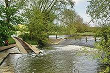
South of Cropredy Bridge, the river runs through fields used for the annual Cropredy Festival, a three-day music event run by the band Fairport Convention. It then passes the site of a former water mill. A sufficient head of water to power the mill was created by a weir system and a millpond. There may have been more rudimentary mill works upstream but this is the first major mill along the river's course.
Banbury
After a few miles the River Cherwell passes under the M40 motorway and enters the industrial hinterland of Banbury, passing the site of another water mill. From here, a main line railway runs alongside on the west side. This line was built by the Great Western Railway and links London and Oxford with Birmingham and the north. South of this point, the railway closely follows the Cherwell valley.
The town of Banbury grew up alongside the River Cherwell. A Roman villa at nearby Wykham Park dates from around the year 250 but it was the Saxons who built the first settlement west of the River Cherwell. On the opposite bank is the Saxon settlement of Grimsbury, now absorbed into Banbury.
Banbury Castle was built in 1135 on the west bank of the Cherwell commanding the river. The castle was extended and rebuilt many times. In the English civil war the castle became a Royalist stronghold and was besieged during the winter of 1644–1645. A second siege began in January 1646 and lasted until April when a surrender was negotiated. Following a petition to the House of Commons in 1648, the castle was demolished.
There was a substantial water mill on the River Cherwell near the castle. The brick-built mill building and the miller's cottage have been modernised and extended to serve Banbury as a theatre and arts centre.
South of Banbury
South of Banbury, the valley of the River Cherwell widens out. On the west bank is a large housing estate built in the 1970s named Cherwell Heights and a mile south the ancient village of Bodicote on higher ground to the west of the river. Downstream of Banbury, most of the villages in the Cherwell valley are similarly set back from the river on higher ground to avoid flooding.
After Bodicote, the river passes an industrial estate at Twyford Mill before reaching King's Sutton, a village noted for the splendid lofty spire on its church which overlooks the river. Two miles further on, the Cherwell reaches the settlement of Nell Bridge and passes under a main road leading to the village of Aynho which is a mile to the east on a low hill overlooking the river. At Kings Sutton it is joined by both the Sor Brook and Mill Lane brook [6][7][8]
Shortly after Nell Bridge, the River Cherwell crosses the Oxford Canal at a right-angle, flowing in on the east side and out over a weir on the west side. Such level river crossings are fairly uncommon on English canals. A few yards below this crossing is Aynho Weir Lock. This lock is unusual in that instead of a rectangular chamber, it has a wide lozenge-shaped chamber. This is because the lock lowers the canal by only 12 inches (300 mm) and the extra width of the lock chamber compensates for the smaller amount of water which would otherwise be passed from the River Cherwell to feed the lower level of the canal.
Adjacent to Aynho Weir, the railway route splits. South of this junction, the original line continues down the Cherwell valley to Oxford; east of it, a more direct route (opened in 1910 by the Great Western Railway) runs via Bicester and High Wycombe to London, originally served by trains to Paddington station but now by trains to Marylebone station. On the line to Oxford, the River Cherwell supplied water to the railway, feeding long troughs laid on top of the sleepers between the rails so that locomotives could scoop up water to replenish their tanks without stopping.
Lower course, Somerton, Heyford, Rousham and Shipton
From Aynho, the River Cherwell meanders in its valley overlooked by hilltop villages. Somerton and Heyford are the only villages adjacent to the river itself and both once had water mills. The mill at Lower Heyford was last rebuilt in the early 19th century and worked as a mill as recently as 1946. However, there was a mill here before the Norman Conquest and this fact is mentioned in the Domesday Book.
At Rousham, the River Cherwell passes a famous landscape garden designed by William Kent. It features many statues and a temple which overlooks the River Cherwell. The terrace by the river is named the Praeneste after the ancient temple in Palestrina near Rome.
Two miles south of Rousham the river is crossed by a medieval packhorse bridge at Northbrook and a further mile south the course of Akeman Street, a Roman road, crosses the river. South of here, the Cherwell valley narrows and becomes more wooded.
The River Cherwell passes under the Woodstock to Bicester road and shortly after the Oxford Canal flows into it from the east. The next mile of the river is used by boats as part of the canal route. The canal and river pass a now-derelict cement works which was once supplied by canal narrowboats and which used water extracted from the river.
After sharing their course for about one mile (1.6 km), the Oxford Canal and River Cherwell diverge at Shipton Weir Lock (a similar lozenge-shaped structure to the lock at Aynho Weir). To the west of the lock is the village of Shipton on Cherwell. The bridge carrying the railway over the canal was the site of a major train crash in December 1874 in which more than 30 people died (Shipton-on-Cherwell train crash).
East of Shipton, the deserted village of Hampton Gay stands on the bank of the River Cherwell. The most substantial remnant is the church which stands in lonely isolation in the watermeadows but there are ruins of a manor house too. Beyond here, the river reaches Thrupp where the Oxford Canal finally leaves the Cherwell valley.
There was a Romano-British settlement not far from the River Cherwell near Kidlington and a substantial Romano-British villa across the river at Islip. To the east of Islip is a wide plain called Otmoor drained by the River Ray and its small tributaries. The Ray, the Cherwell's largest tributary, flows into the Cherwell at a weir in Islip, known as The Stank.
The city of Oxford

The River Cherwell reaches the northern outskirts of Oxford and runs south on the eastern edge of north Oxford town centre. Near Summertown it passes the Victoria Arms riverside pub at Marston and then under a modern bridge that is part of Marston Ferry Road. A little further south, the Cherwell passes Wolfson College (a graduate college of Oxford University), the Cherwell Boathouse (where punts can be hired) and the playing fields of the Dragon School. Next is Lady Margaret Hall, one of the previously all-women's Oxford colleges.
The river is then flanked by Oxford University Parks and passes under Rainbow Bridge. Parson's Pleasure and Dame's Delight used to provide nude bathing facilities for male and female bathers respectively, but both are now defunct. Below the Parks, the river splits into up to three streams, with a series of islands. One is Mesopotamia, which is a long thin island just south of the Parks with a path that provides a pleasant walk. At the northern end, there are punt rollers next to a weir. St Catherine's College is on the largest island formed by the split of the river. It also flows past Magdalen College (pronounced 'maudlin').
The river conjoins again into two close streams to flow under Magdalen Bridge. Early on May Morning, students sometimes jump off the bridge into the river, but this is a dangerous pastime, especially if the river is low. The river splits again past the bridge. To the west is the Oxford Botanic Garden. To the east are Magdalen College School and St Hilda's College. The river then skirts Christ Church Meadow before flowing into the River Thames (or Isis) through two branches. On the island in between these branches are many of the college boathouses for rowing on the Thames.
In summer, punting is very popular on the Oxford stretch of the Cherwell. (A punt is a long flat bottom boat which is propelled by means of a pole pushed against the river bed.) Punts are typically hired from a punt station by Magdalen Bridge, or the Cherwell Boathouse (just to the north of the University Parks). It is possible to punt all the way from the Isis, north past the University Parks, and out beyond the ring road.
The Withywindle river in J. R. R. Tolkien's fantasy world of Middle-earth has been identified with the River Cherwell near Tolkien's home in Oxford.[9]
The confluence of the Thames and Cherwell was the site of early settlements and the River Cherwell marked the boundary between the Dobunni tribe to the west and the Catuvellauni tribe to the east (these were pre-Roman Celtic tribes).
A Romano-British settlement grew up north of the confluence, partly because the site was naturally protected from attack on the east by the River Cherwell and on the west by the River Thames. This settlement dominated the pottery trade in what is now central southern England and pottery was distributed by boats on the Thames and its tributaries.
Navigation
The river has never been properly navigable. In the 17th century goods seem to have been carried between Oxford and Banbury in flat-bottomed boats, but the river was not made properly navigable. A boatload of coal was taken up the river in 1764 as a test. Since the opening of the Oxford Canal in 1790 the river has been used only by small pleasure craft.[10]
See also
References
- ↑ "Oxford - Places - How do you pronounce Cherwell?". BBC. 2009-06-26. Retrieved 2014-02-02.
- ↑ Ann Spokes Symonds; Nigel Morgan (2010). The Origins of Oxford Street Names. p. 36. ISBN 978-1-899536-99-3.
- ↑ Jean Stone (28 February 2014). River Cherwell. Amberley Publishing Limited. pp. 6–9. ISBN 978-1-4456-3450-0.
- ↑ Minutes of Proceedings of the Institution of Civil Engineers. 1863. pp. 339–340.
- ↑ "227_10_SD01 Licence strategy template" (PDF). Retrieved 2014-02-02.
- ↑ http://www.british-history.ac.uk/rchme/northants/vol4/pp92-96
- ↑ http://www.kingssutton.net/Memories.html
- ↑ https://canalrivertrust.org.uk/see-and-do/routes/clifton-and-adderbury
- ↑ Shippey, T. A. (2000), J. R. R. Tolkien: Author of the Century, Harper Collins, p.63, ISBN 0 261 10400 4
- ↑ Crossley, Alan; Elrington, C.R. (eds.); Chance, Eleanor; Colvin, Christina; Cooper, Janet; Day, C.J.; Hassall, T.G.; Selwyn, Nesta (1979). A History of the County of Oxford, Volume 4: Communications: Rivers and River Navigation. Victoria County History.
External links
| Next confluence upstream | River Thames | Next confluence downstream |
| Castle Mill Stream (north) | River Cherwell | Hinksey Stream (south) |