Charterhouse, Somerset
| Charterhouse | |
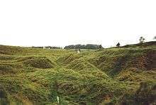
 Charterhouse, looking west |
|
 Charterhouse |
|
| OS grid reference | ST497557 |
|---|---|
| District | Mendip |
| Shire county | Somerset |
| Region | South West |
| Country | England |
| Sovereign state | United Kingdom |
| Post town | BRISTOL |
| Postcode district | BS40 |
| Dialling code | 01761 |
| Police | Avon and Somerset |
| Fire | Devon and Somerset |
| Ambulance | South Western |
| EU Parliament | South West England |
| UK Parliament | Wells |
Coordinates: 51°17′55″N 2°43′20″W / 51.2986°N 2.7221°W
Charterhouse, also known as Charterhouse-on-Mendip, is a hamlet in the Mendip Hills Area of Outstanding Natural Beauty (AONB) in the English county of Somerset. The area between Charterhouse and Cheddar Gorge including Velvet Bottom and Ubley Warren is covered by the Cheddar Complex Site of Special Scientific Interest.
Name
The name is believed to come from the Carthusian order of Chartreuse in France, which was established in Witham (near Frome) in 1181 and formed a cell at Charterhouse in 1283 with a grant to mine lead ore.[1][2][3]
History
There is evidence, in the form of burials in local caves, of human occupation since the late Neolithic/Early Bronze Age.[4]
The lead and silver mines at Charterhouse, were first operated on a large scale by the Romans, from at least AD 49.[5] At first the lead/silver industries were tightly controlled by the Roman military, but within a short time the extraction of these metals was contracted out to civilian companies, probably because the silver content of the local ore was not particularly high.[6] There was also some kind of 'fortlet' here in the 1st century, and an amphitheatre.[7] The Roman landscape has been designated as a Scheduled Ancient Monument.[8]
The parish was part of the Winterstoke Hundred.[9]
After the dissolution of the monasteries, it was granted to Robert May who constructed a substantial house here and one of his descendants John May became High Sheriff of Somerset in 1602.[2]
There is further evidence of mine workings in the medieval and Victorian periods,[10][11] some of which survives within the Blackmoor Nature Reserve owned by Somerset County Council. There is also evidence of a rectangular medieval enclosure.[12]
AONB Centre
The outdoor activity centre and headquarters of the Mendip Hills AONB is based at Charterhouse, with accommodation, classrooms and offices.
Caves
There are several caves in the limestone around the village including Manor Farm Swallet and Upper Flood Swallet.
Church

The Church Of St Hugh was built in 1908 by W.D. Caroe, on the initiative of the Rev. Menzies Lambrick,[13] from the former welfare hall for the lead miners. It is a Grade II* listed building.[14] A cross in the churchyard[15] and the churchyard wall[16] are also listed buildings.
The roof-truss, screen, rood, and altar are all made of carved whitened oak.[13]
References
- ↑ Robinson, Stephen (1992). Somerset Place Names. Wimborne, Dorset: The Dovecote Press Ltd. ISBN 1-874336-03-2.
- 1 2 Reid, Robert Douglas (1979). Some buildings of Mendip. The Mendip Society. ISBN 0-905459-16-4.
- ↑ "Autumn newsletter 2007" (PDF). Mendip Hills AONB. Retrieved 25 September 2007.
- ↑ "Mendip Hills: An Archaeological Survey of the Area of Outstanding Natural Beauty" (PDF). Somerset County Council Archaeological Projects. Retrieved 15 January 2011.
- ↑ Havinden, Michael (1981). The Somerset Landscape. The making of the English landscape. London: Hodder and Stoughton. pp. 58–59. ISBN 0-340-20116-9.
- ↑ "Major Romano-British Settlement Charterhouse on Mendip, Avon". Roman Britain.org. Retrieved 28 October 2006.
- ↑ "Charterhouse". Big Roman Dig. Retrieved 28 October 2006.
- ↑ Firth, Hannah (2007). Mendip from the air. Taunton: South West Heritage Trust. ISBN 978-0-86183-390-0.
- ↑ "Somerset Hundreds". GENUKI. Retrieved 9 September 2011.
- ↑ "Mendip Hills: An Archaeological Survey of the Area of Outstanding Natural Beauty" (PDF). Somerset County Council Archaeological Projects. Retrieved 28 October 2006.
- ↑ Gough, J.W. (1967). The mines of Mendip. Newton Abbot, Devon: David & Charles.
- ↑ Adkins, Lesley and Roy (1992). A Field Guide to Somerset Archaeology. Wimborne, Dorset: Dovecote Press. pp. 37–39. ISBN 0-946159-94-7.
- 1 2 Staveacre, Tony (December 2006). "Christmas at Charterhouse". Mendip Times. 2 (7): 8.
- ↑ "Church of St Hugh". Images of England. Retrieved 29 October 2006.
- ↑ "Churchyard Cross in churchyard, Church of St Hugh". Images of England. Retrieved 29 October 2006.
- ↑ "Churchyard Wall to Church of St Hugh". Images of England. Retrieved 29 October 2006.
External links
| Wikimedia Commons has media related to Charterhouse, Somerset. |