River Washburn
| River Washburn | |
|---|---|
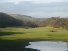 The River Washburn approaching Lindley Wood Reservoir | |
| Country | England |
| Basin | |
| Main source |
Washburn Head 391 m (1,283 ft) 54°3′46″N 1°50′50″W / 54.06278°N 1.84722°W |
| River mouth |
River Wharfe near Pool 49 m (161 ft) 53°54′39″N 1°39′6″W / 53.91083°N 1.65167°WCoordinates: 53°54′39″N 1°39′6″W / 53.91083°N 1.65167°W |
| Basin size | 87.3 km2 (33.7 sq mi)[1] |
| Physical characteristics | |
| Length | 26 km (16 mi) |
The River Washburn is a river in Yorkshire, England. It originates high in the Yorkshire Dales and ends where it meets the River Wharfe. It lies within the Nidderdale Area of Outstanding Natural Beauty.[2]
Course
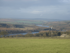
The river's source is at Washburn Head, just south of Stump Cross Caverns and from there flows southwards via Thruscross Reservoir, Blubberhouses, Fewston Reservoir, Swinsty Reservoir and Lindley Wood Reservoir before joining the River Wharfe just north-west of Pool-in-Wharfedale.
Reservoirs
The Washburn has been dammed to a series of four reservoirs, all built to supply water to the city of Leeds. The lower three (Lindley Wood, Swinsty and Fewston) were built at the end of the 19th century, while the fourth, Thruscross, was delayed until the 1960s.[3] Fewston and Swinsty Reservoirs have a surface area of around 1.6 km² and a combined length of 4.1 km and Thackray Beck and Spinksburn Beck are major tributaries flowing into these reservoirs.[4] Capelshaw Beck is the main tributary flowing into Thruscross reservoir.[2]
Geology
Where the valley has not been flooded to make reservoirs, the sides are 'V' shaped. The valley floor consists of solid Millstone Grit overlain with till drift. The drainage can be described as slowly permeable and seasonally waterlogged. The bedrock is covered with fine loam over clay soils and some peat soils at higher elevations on the fringe of the moorland.[2][4][5]
Geography
The river valley has grassland that is intensively managed for livestock. There are also a range of field sizes, bounded by stonewalls often reinforced with post and wire fencing plus some post and rail fencing. There are very large forestry conifer plantations around the reservoirs as well as at Beecroft Moor Plantation with conifer shelterbelts at Carlhow Ridge Plantation. Deciduous tree clumps can be found around settlements. Ancient Semi-Natural woodland can still be seen at Blubberhouses, Folly Hall Wood, Hanging Wood and Ellers Wood. There is evidence of past quarrying of local stone for buildings and walls. The river valley is crossed by the Harrogate Dales Way Link.[2][4]
Further reading
- The Washburn by Tom Bradley (published 1895, reprinted 1988)
- Washburn Valley Yesterday Vol II by David Alred. ISBN 1-85825-160-5
See also
References
- ↑ "Washburn Statistics". National River Flow Archives. Centre for Ecology & Hydrology. Retrieved 18 February 2011.
- 1 2 3 4 "Upper Washburn Valley" (PDF). Retrieved 1 May 2011.
- ↑ Bowtell, Harold D (1991). Lesser Railways of the Yorkshire Dales and the Dam Builders in the Age of Steam. Plateway Press. ISBN 1-871980-09-7.
- 1 2 3 "Middle Washburn Valley" (PDF). Retrieved 1 May 2011.
- ↑ "Y.G.S.Extract". Retrieved 1 May 2011.