Flintshire
| Flintshire Welsh: Sir y Fflint | ||
|---|---|---|
| County and Principal area | ||
| ||
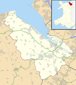
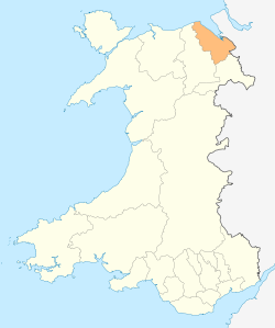 Flintshire shown within Wales | ||
| Sovereign state |
| |
| Constituent country |
| |
| Preserved county | Clwyd | |
| Established | 1 April 1996 | |
| Administrative HQ | Mold | |
| Government | ||
| • Type | Principal council | |
| • Body | Flintshire County Council | |
| • Executive | TBA (council NOC) | |
| • Leader | Aaron Shotton (Labour) | |
| • Chairman | Ray Hughes | |
| • Chief Executive | Colin Everett | |
| • MPs |
David Hanson (L) Mark Tami (L) | |
| Area | ||
| • Total | 169 sq mi (438 km2) | |
| Area rank | 12th | |
| Population (2011) | ||
| • Total | 152,500 | |
| • Rank | 6th | |
| • Density | 890/sq mi (342/km2) | |
| • Ethnicity | 97.8% white | |
| Time zone | Greenwich Mean Time (UTC+0) | |
| • Summer (DST) | British Summer Time (UTC+1) | |
| Postcode areas |
CH LL | |
| Dialling codes |
01352 01745 | |
| GSS code | W06000005 | |
| ISO 3166-2 | GB-FLN | |
| NUTS 3 code | UKL23 | |
| ONS code | 00NJ | |
| Website | www.flintshire.gov.uk | |

Flintshire (Welsh: Sir y Fflint) is a county in north-east Wales, bordering the English county of Cheshire to the east, Denbighshire to the west and Wrexham County Borough to the south. It is named after the historic county of Flintshire which had notably different borders. Flintshire is considered part of the Welsh Marches and formed part of the historic Earldom of Chester and Flint. The county is governed by Flintshire County Council.
History
Flintshire takes its name from the former county of Flintshire established in 1536 which existed until 1974 when it was abolished under the Local Government Act 1972. Its re-establishment in 1996 under the Local Government (Wales) Act 1994 does not follow those original boundaries but covers a smaller area.
Early history
At the time of the Roman invasion, the area of present-day Flintshire was inhabited by the Deceangli, one of the Celtic tribes in ancient Britain, with the Cornovii to the east and the Ordovices to the west. Lead and silver mine workings are evident in the area, with several sows of lead found bearing the name 'DECEANGI' inscribed in Roman epigraphy.[1] The Deceangli appear to have surrendered to Roman rule with little resistance. Following Roman Britain, and the emergence of various petty kingdoms, the region had been divided into the Hundred of Englefield (Welsh: Cantref Tegeingl), derived from the Latin Deceangli.

It became part of the Kingdom of Mercia by the 8th century, with much of the western boundary reinforced under Offa of Mercia after 752 CE, but there is evidence that Offa's Dyke is probably a much earlier construction.[2] By the time of the Norman conquest in 1066 it was under the control of Edwin of Tegeingl, from whose Lordship the Flintshire coat of arms is derived. Edwin's mother is believed to have been Ethelfleda or Aldgyth, daughter of Eadwine of Mercia. At the time of the establishment of the Earldom of Chester, which succeeded the Earl of Mercia, the region formed two of the then twelve Hundreds of Cheshire of which it remained a part for several hundred years.[3]
Flintshire today approximately resembles the boundaries of the Hundred of Atiscross as it existed at the time of the Domesday Book.[4] Atiscross, along with the Hundred of Exestan, was transferred from the Earldom of Chester to the expanding Kingdom of Gwynedd[5] from the west in the 13th century following numerous military campaigns. This region, as well as an exclave formed from part of the Hundred of Dudestan (known as Maelor Saesneg), later formed the main areas of Flintshire, established by the Statute of Rhuddlan in 1284 under Edward I. It was administered with the Palatinate of Chester and Flint by the Justiciar of Chester. The county was consolidated in 1536 by the Laws in Wales Acts 1535–1542 under the Tudor King Henry VIII, when it was incorporated into the Kingdom of England. Flintshire remained in existence until 1974 when it was merged with Denbighshire and Edeyrnion Rural District to form the administrative county of Clwyd. Clwyd was abolished only 22 years later and Flintshire re-established in its present form in 1996. However, some parts of the historic country are not included within the present boundaries of Flintshire: significantly English Maelor was incorporated into Wrexham County Borough, and St Asaph, Prestatyn and Rhyl into Denbighshire.
Modern history
The current administrative area of Flintshire (a unitary authority) came into existence in 1996, when the former administrative county of Clwyd was split into three smaller areas. The principal area was formed by the merger of the Alyn and Deeside and Delyn districts. In terms of pre-1974 divisions, the area comprises
- the former borough of Flint
- the urban districts of Buckley, Connah's Quay, Holywell, Mold
- the rural district of Holywell Rural District
- all of Hawarden Rural District except the parish of Marford and Hosley
The district of Rhuddlan, which was also formed entirely from the administrative county of Flintshire was included in the new Denbighshire instead. Other parts of the pre-1974 administrative Flintshire to be excluded from the principal area are the Maelor Rural District and the parish of Marford and Hoseley, which became part of the Wrexham Maelor district in 1974 and are now part of Wrexham County Borough.
Geography
- See List of places in Flintshire for a list of towns and villages.
Flintshire is a maritime county bounded to the north by the Dee estuary, to the east by Cheshire, to the west by Denbighshire and to the south by Wrexham County Borough. The coast along the Dee estuary is heavily developed by industry and the north coast much developed for tourism. The Clwydian Mountains occupy much of the west of the county. The highest point is Moel Famau (1,820 feet/554 metres). The chief towns are Buckley, Connah's Quay, Flint, Hawarden, Holywell, Mold, Queensferry, and Shotton. The main rivers are the Dee (the estuary of which forms much of the coast) and the Clwyd.
Historic buildings and structures


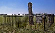
Ancient Cross at Whitford 
Railways
Located on the North Wales Coast Line (Holyhead to Chester) with services run by Virgin Trains and Arriva Trains Wales specifically calling at Flintshire stations such as Flint and Shotton with an interchange at Shotton with the Borderlands Line, which links other Flintshire stations with the Liverpool area.
Industry
Parts of Flintshire have major manufacturing industries. Amongst these are an advanced Toyota plant that manufactures engines, a TATA steelworks, Shotton Paper, and Airbus, making the wings for the A330 and the A380 at Broughton.
There are daily flights of the Airbus Beluga transport aircraft of Airbus wings from Broughton for the smaller aircraft. The wings for the A380, which are too large to be transported by air, use a multi-modal transport using Flintshire's roads, the River Dee and the port of Mostyn, also in Flintshire.
Flintshire is also known for its internet companies, the largest and most well known being Moneysupermarket.com based in Ewloe.
Flintshire included much of the North Wales Coalfield, with the last colliery at Point of Ayr closing in 1996.
Flintshire is home to Shotwick Solar Park, the largest Solar array in the UK, built on the south west edge of the Wirral Peninsula. It has a maximum generating capacity of 45 MW.
Fairtrade
On 19 November 2004, Flintshire was granted Fairtrade County status.
Education
Flintshire County Council is the Local Education Authority of Flintshire. It runs 72 primary schools, 2 special schools and 12 secondary schools.
Four of the secondary schools have come together with Coleg Cambria to form the Deeside Consortium.
See also
- List of Lord Lieutenants of Flintshire
- List of High Sheriffs of Flintshire
- List of Scheduled Monuments in Flintshire
References
- ↑ "The Celtic tribes of Britain". Roman Britain Organisation. Retrieved 3 May 2014.
- ↑ "Offa's Dyke: built by multiple kings?". Current Archaeology. XXV, No. 3 (291): 6. June 2014.
- ↑ Higham, Nick (1993). The origins of a County. Manchester University Press. ISBN 0-7190-3160-5.
- ↑ http://domesdaymap.co.uk/search/?geo=atis%27s+cross
- ↑ Harris & Thacker (1987, pp. 340–341)
External links
| Wikimedia Commons has media related to Flintshire. |
| Wikivoyage has a travel guide for Flintshire. |
- Flintshire at DMOZ
- Flintshire archaeological information
- Chester Recognizance Rolls calendar surname-indexed with scans