Ohio State Route 73
| ||||
|---|---|---|---|---|
 | ||||
| Route information | ||||
| Maintained by ODOT | ||||
| Length: | 134.80 mi[1] (216.94 km) | |||
| Existed: | 1924 – present | |||
| Major junctions | ||||
| West end: |
| |||
|
| ||||
| East end: |
| |||
| Location | ||||
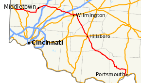
| Counties: | Butler, Warren, Clinton, Highland, Adams, Scioto | |||
| Highway system | ||||
| ||||

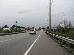
Eastbound in Wilmington, Ohio
State Route 73 (SR 73) is an east–west state highway in the southern portion of the U.S. state of Ohio. Its western terminus is on U.S. Route 27 in Oxford at the intersection of SR 732. SR 73’s eastern terminus is in Portsmouth at US 23; this is also the southern terminus of SR 104, and the two state routes run concurrent for over 6 miles (9.7 km) from this point north. Once SR 73 enters Scioto County, it is designated as the Scenic Scioto Heritage Trail by the Ohio Department of Transportation.[2]
In combination with SR 32, SR 73's easternmost 31 miles (50 km) are part of the quickest route between Cincinnati and Portsmouth. Also SR 73 has turned into a bypass for Wilmington.
Points of interest
- Great Miami River - Middletown, Franklin
- Excello Locks - Historic Remains of a lock on the Miami-Erie Canal near the intersection of 73 and S. Main St. in Middletown, Ohio. Much of the route between Trenton and Franklin follows the original path of the Miami and Erie Canal.
- Middletown Historical Society Canal Museum
- La Comedia Dinner Theatre - Springboro
- Little Miami River - Waynesville
- Little Miami Bike Trail - Corwin
- Caesar Creek Lake - Warren County
- Caesar Creek State Park - Warren, Clinton County
- Serpent Mound
- Brush Creek State Forest
- Shawnee State Forest
- Scioto River
- Ohio River
History
- 1924 – Original route established;[3] originally routed from Franklin to 1-mile (1.6 km) west of Portsmouth (dually certified with State Route 104 from 1-mile (1.6 km) north of Coles Park to 1-mile (1.6 km) west of Portsmouth before 1926).[4]
- 1926 – Extended to 2 miles (3.2 km) east of Middletown along the previous State Route 6; State Route 104 certification removed.[4]
- 1934 – Extended to the U.S. Route 127 about 1-mile (1.6 km) northwest of Seven Mile.[4]
- 1936 – Extended to Oxford.[4]
- 1952 – Dually certified with State Route 104 from 1-mile (1.6 km) north of Coles Park to 1-mile (1.6 km) west of Portsmouth.[4]
- 1957 – From Excello to Franklin upgraded to 4 lanes.[4]
- 1962 – From 1-mile (1.6 km) north of West Portsmouth to 1-mile (1.6 km) west of Portsmouth upgraded to 4 lanes.[4]
- 1966 – From Franklin to Interstate 75 upgraded to 4 lanes.[4]
- 1972 – Extended to Portsmouth (dually certified with State Route 104)[4] along the former alignment of U.S. Route 23.
- 1979 – From Interstate 75 to Springboro upgraded to divided highway.[4]
- 1980 – From Trenton to Excello upgraded to divided highway.[4]
Major junctions
| County | Location | mi[1] | km | Destinations | Notes | ||
|---|---|---|---|---|---|---|---|
| Butler | Oxford | 0.00 | 0.00 | Western end of US 27 concurrency | |||
| 0.81 | 1.30 | Eastern end of US 27 concurrency | |||||
| Milford Township | 4.38 | 7.05 | |||||
| 7.32 | 11.78 | Western end of US 127 concurrency | |||||
| Wayne Township | 9.89 | 15.92 | Eastern end of US 127 concurrency | ||||
| 10.72 | 17.25 | ||||||
| Lemon Township | 18.23– 18.87 | 29.34– 30.37 | Western end of SR 4 concurrency | ||||
| Middletown | 20.99 | 33.78 | Western end of SR 122 eastbound concurrency (northbound SR 4 / eastbound SR 73 only) | ||||
| 21.05 | 33.88 | Eastern end of SR 122 eastbound concurrency (northbound SR 4 / eastbound SR 73 only) | |||||
| 21.44 | 34.50 | ||||||
| 22.55 | 36.29 | Eastern end of SR 4 concurrency | |||||
| Warren | Franklin | 27.41 | 44.11 | Western end of SR 123 concurrency | |||
| 27.76 | 44.68 | Eastern end of SR 123 concurrency | |||||
| Franklin–Springboro city line | 29.48– 29.69 | 47.44– 47.78 | Exit 38 (I-75) | ||||
| Springboro | 31.57 | 50.81 | |||||
| Clearcreek Township | 35.31 | 56.83 | |||||
| Waynesville | 39.98 | 64.34 | |||||
| Clinton | Chester Township | 48.67– 48.91 | 78.33– 78.71 | Exit 45 (I-71) | |||
| 49.08 | 78.99 | ||||||
| Western end of freeway | |||||||
| Union Township | 54.56– 55.20 | 87.81– 88.84 | |||||
| Wilmington | 58.17– 58.86 | 93.62– 94.73 | |||||
| Eastern end of freeway | |||||||
| Green Township | 66.46 | 106.96 | Western end of SR 350 concurrency | ||||
| 66.70 | 107.34 | Southern terminus of SR 729 | |||||
| New Vienna | 68.80 | 110.72 | Eastern end of SR 350 concurrency | ||||
| Highland | Hillsboro | 78.58 | 126.46 | Western end of US 50 / SR 124 concurrency | |||
| 78.71 | 126.67 | Eastern end of US 50 / SR 124 concurrency; western end of US 62 / SR 138 concurrencies | |||||
| 78.90 | 126.98 | Eastern end of SR 138 concurrency | |||||
| 79.08 | 127.27 | Eastern end of US 62 concurrency | |||||
| 79.22 | 127.49 | Northern terminus of SR 247 | |||||
| Jackson Township | 89.92 | 144.71 | Eastern terminus of SR 785 | ||||
| Highland–Adams county line | Jackson–Bratton township line | 92.64 | 149.09 | Northern terminus of SR 770 | |||
| Adams | Franklin Township | 100.28 | 161.39 | Western end of SR 41 concurrency | |||
| 100.54 | 161.80 | Eastern end of SR 41 concurrency | |||||
| 103.00– 103.02 | 165.76– 165.79 | ||||||
| Scioto | Rarden | 109.80 | 176.71 | Southern terminus of SR 772 | |||
| Otway | 115.13 | 185.28 | Western end of SR 348 concurrency | ||||
| 115.28 | 185.53 | Eastern end of SR 348 concurrency | |||||
| Union Township | 121.13 | 194.94 | Norther terminus of SR 371 | ||||
| Rush Township | 128.43 | 206.69 | Western end of SR 104 concurrency | ||||
| Washington Township | 132.45 | 213.16 | Northern terminus of SR 239 | ||||
| 132.98– 133.71 | 214.01– 215.19 | Interchange; northern terminus of SR 852; no access from SR 73 westbound to US 52 eastbound | |||||
| Portsmouth | 134.69 | 216.76 | Western end of US 23 southbound concurrency | ||||
| 134.80 | 216.94 | Eastern end of US 23 southbound / SR 104 concurrencies | |||||
1.000 mi = 1.609 km; 1.000 km = 0.621 mi
| |||||||
References
- 1 2 "DESTAPE". Ohio Department of Transportation. July 16, 2013. Retrieved September 21, 2014.
- ↑ Ohio Department of Transportation. "Ohio Byways". Retrieved 2007-07-18.
- ↑ Explanation of the Ohio State Highway System (The Unofficial Ohio State Highways Web Site) by John Simpson Archived May 23, 2006, at the Wayback Machine.
- 1 2 3 4 5 6 7 8 9 10 11 Route 73 (The Unofficial Ohio State Highways Web Site) by John Simpson Archived December 23, 2004, at the Wayback Machine.
External links
This article is issued from Wikipedia - version of the 11/15/2016. The text is available under the Creative Commons Attribution/Share Alike but additional terms may apply for the media files.