Ohio State Route 28
| ||||
|---|---|---|---|---|
 | ||||
| Route information | ||||
| Maintained by ODOT | ||||
| Length: | 70.68 mi[1] (113.75 km) | |||
| Existed: | 1926 – present | |||
| Major junctions | ||||
| West end: |
| |||
|
| ||||
| East end: |
| |||
| Location | ||||
| Counties: | Hamilton, Clermont, Warren, Clinton, Highland, Ross | |||
| Highway system | ||||
| ||||

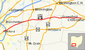
State Route 28 (SR 28) is an east–west state highway in the U.S. state of Ohio. Both of the route’s termini are on U.S. Route 50, beginning in Milford at the eastern terminus of State Route 126 and ending near Chillicothe. The route has an interchange with Interstate 275, and also intersects with U.S. Route 68 and U.S. Route 62. The route was formerly signed as State Route 27 before that number was assigned to U.S. Route 27 in 1926.
History
- 1926 – Original certified; no significant changes since it was established.[2]
Before 1926
State Route 27 ran from Cincinnati to West Jefferson in 1924. This former alignment is occupied by U.S. Route 42 from Cincinnati to London, and State Route 142 from London to West Jefferson.[2]
Ohio 28 Bypass
State Route 28 becomes a short controlled-access highway after the intersection with 275. Along the four lane expressway, which allows commuters to avoid the traffic associated with the shops along old 28, there are exits to North and South Wolfpen-Pleasant Hill Road on eastbound, but there are no exits westbound.
Major junctions
| County | Location | mi[1] | km | Destinations | Notes |
|---|---|---|---|---|---|
| Hamilton | Milford | 0.00 | 0.00 | Western end of US 50 concurrency; eastern terminus of SR 126 | |
| Clermont | 0.87 | 1.40 | Eastern end of US 50 concurrency | ||
| Miami Township | 2.23– 2.49 | 3.59– 4.01 | Exit 57 (I-275) | ||
| 3.52– 3.76 | 5.66– 6.05 | CR 132 (Wolfpen-Pleasant Hill Road) | Interchange; no eastbound entrance / westbound exit | ||
| Goshen Township | 7.09 | 11.41 | Western end of SR 48 concurrency | ||
| 7.49 | 12.05 | Eastern end of SR 48 concurrency | |||
| 8.66 | 13.94 | Western end of SR 132 concurrency | |||
| 10.06 | 16.19 | Eastern end of SR 132 concurrency | |||
| Warren | Harlan Township | 18.24 | 29.35 | Western end of SR 123 concurrency | |
| Clinton | Blanchester | 19.20 | 30.90 | Eastern end of SR 123 concurrency | |
| Jefferson Township | 23.77 | 38.25 | |||
| Clark Township | 29.99 | 48.26 | |||
| New Vienna | 35.38 | 56.94 | Eastern terminus of SR 350 | ||
| Highland | Highland | 40.89 | 65.81 | Western end of SR 72 concurrency | |
| Fairfield Township | 41.47 | 66.74 | Eastern end of SR 72 concurrency | ||
| Leesburg | 42.98 | 69.17 | |||
| 43.26 | 69.62 | Northern terminus of SR 771 | |||
| Greenfield | 52.64 | 84.72 | Western end of SR 138 / SR 753 concurrencies | ||
| 53.08 | 85.42 | Eastern end of SR 753 concurrency; western end of SR 41 concurrency | |||
| Ross | Buckskin Township | 53.66 | 86.36 | Eastern end of SR 138 concurrency | |
| 53.96 | 86.84 | Eastern end of SR 41 concurrency | |||
| Twin Township | 70.69 | 113.76 | |||
1.000 mi = 1.609 km; 1.000 km = 0.621 mi
| |||||
References
- 1 2 "DESTAPE". Ohio Department of Transportation. July 3, 2014. Retrieved October 4, 2014.
- 1 2 Route 28 (The Unofficial Ohio State Highways Web Site) by John Simpson Archived December 16, 2004, at the Wayback Machine.