Jackson, Ohio
| Jackson, Ohio | |
|---|---|
| City | |
|
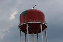
A view of Jackson's welcome sign and city's water tower while traveling north on SR 93 | |
| Motto: "We make things happen!" | |
 Location of Jackson, Ohio | |
 Detailed map of Jackson | |
| Coordinates: 39°3′3″N 82°38′23″W / 39.05083°N 82.63972°WCoordinates: 39°3′3″N 82°38′23″W / 39.05083°N 82.63972°W | |
| Country | United States |
| State | Ohio |
| County | Jackson |
| Government | |
| • Mayor | Randy Heath |
| Area[1] | |
| • Total | 8.49 sq mi (21.99 km2) |
| • Land | 8.23 sq mi (21.32 km2) |
| • Water | 0.26 sq mi (0.67 km2) |
| Elevation[2] | 692 ft (211 m) |
| Population (2010)[3] | |
| • Total | 6,397 |
| • Estimate (2012[4]) | 6,336 |
| • Density | 777.3/sq mi (300.1/km2) |
| Time zone | Eastern (EST) (UTC-5) |
| • Summer (DST) | EDT (UTC-4) |
| ZIP code | 45640 |
| Area code(s) | 740 |
| FIPS code | 39-37842[5] |
| GNIS feature ID | 1061427[2] |
| Website | http://www.jacksonohio.us/ |
Jackson is a city in and the county seat of Jackson County, Ohio, United States.[6] The population was 6,397 at the 2010 census.
Geography
Jackson is located at 39°3′3″N 82°38′23″W / 39.05083°N 82.63972°W (39.050784, -82.639584).[7]
According to the United States Census Bureau, the city has a total area of 8.49 square miles (21.99 km2), of which 8.23 square miles (21.32 km2) is land and 0.26 square miles (0.67 km2) is water.[1]
Demographics
Jackson has the eighth largest population of people of Welsh descent in the United States, and fourth largest in Ohio.[8] The Welsh-American Heritage Museum in Oak Hill describes the experience of Welsh immigration to this area and their chief occupations in farming, making iron, and manufacturing clay.[9]
| Historical population | |||
|---|---|---|---|
| Census | Pop. | %± | |
| 1830 | 136 | — | |
| 1840 | 297 | 118.4% | |
| 1850 | 480 | 61.6% | |
| 1860 | 1,067 | 122.3% | |
| 1870 | 2,016 | 88.9% | |
| 1880 | 3,021 | 49.9% | |
| 1890 | 4,320 | 43.0% | |
| 1900 | 4,672 | 8.1% | |
| 1910 | 5,468 | 17.0% | |
| 1920 | 5,842 | 6.8% | |
| 1930 | 5,922 | 1.4% | |
| 1940 | 6,295 | 6.3% | |
| 1950 | 6,504 | 3.3% | |
| 1960 | 6,980 | 7.3% | |
| 1970 | 6,843 | −2.0% | |
| 1980 | 6,675 | −2.5% | |
| 1990 | 6,144 | −8.0% | |
| 2000 | 6,184 | 0.7% | |
| 2010 | 6,397 | 3.4% | |
| Est. 2015 | 6,243 | [10] | −2.4% |
| Sources:[5][11][12][13][14][15][16][17] | |||

2010 census
As of the census[3] of 2010, there were 6,397 people, 2,734 households, and 1,698 families residing in the city. The population density was 777.3 inhabitants per square mile (300.1/km2). There were 3,019 housing units at an average density of 366.8 per square mile (141.6/km2). The racial makeup of the city was 96.4% White, 0.7% African American, 0.3% Native American, 0.4% Asian, 0.4% from other races, and 1.7% from two or more races. Hispanic or Latino of any race were 1.5% of the population.
There were 2,734 households of which 32.3% had children under the age of 18 living with them, 40.5% were married couples living together, 17.2% had a female householder with no husband present, 4.4% had a male householder with no wife present, and 37.9% were non-families. 33.5% of all households were made up of individuals and 14.2% had someone living alone who was 65 years of age or older. The average household size was 2.32 and the average family size was 2.94.
The median age in the city was 38.1 years. 23.8% of residents were under the age of 18; 9.6% were between the ages of 18 and 24; 26% were from 25 to 44; 26% were from 45 to 64; and 14.7% were 65 years of age or older. The gender makeup of the city was 46.5% male and 53.5% female.
2000 census
As of the census[5] of 2000, there were 6,184 people, 2,667 households, and 1,712 families residing in the city. The population density was 823.4 people per square mile (317.9/km²). There were 2,905 housing units at an average density of 386.8 per square mile (149.4/km²). The racial makeup of the city was 98.19% White, 0.44% African American, 0.19% Native American, 0.26% Asian, 0.03% Pacific Islander, 0.29% from other races, and 0.60% from two or more races. Hispanic or Latino of any race were 0.86% of the population.
There were 2,667 households out of which 30.9% had children under the age of 18 living with them, 45.8% were married couples living together, 14.2% had a female householder with no husband present, and 35.8% were non-families. 32.4% of all households were made up of individuals and 14.6% had someone living alone who was 65 years of age or older. The average household size was 2.32 and the average family size was 2.91.
In the city the population was spread out with 24.7% under the age of 18, 8.9% from 18 to 24, 27.8% from 25 to 44, 22.2% from 45 to 64, and 16.3% who were 65 years of age or older. The median age was 38 years. For every 100 females there were 85.1 males. For every 100 females age 18 and over, there were 80.3 males.
The median income for a household in the city was $26,728, and the median income for a family was $33,456. Males had a median income of $31,131 versus $21,612 for females. The per capita income for the city was $14,855. About 14.6% of families and 18.7% of the population were below the poverty line, including 23.6% of those under age 18 and 18.4% of those age 65 or over.
History
Established in 1817,[18] residents named the town after Andrew Jackson, a hero of the War of 1812, and an eventual president of the United States.[19] The community grew slowly, having only 297 inhabitants in 1840. In 1846, Jackson contained four churches, approximately seven stores, and a single newspaper office. Over the next forty years the town grew quickly, attaining a population of 3,021 people in 1880. By 1880 two railroad lines passed through the community, helping to spur economic and population growth. In 1886 two newspaper offices, eight churches, and two banks existed in Jackson. The largest businesses in the town were the Star Furnace Company and the Globe Iron Company with thirty employees apiece. Both firms used local coal and iron ore deposits to make iron products.
Jackson continued to grow during the twentieth century. Jackson was the county's largest community in 2000, with a population of 6,184 people. This number amounted to approximately twenty percent of the county's entire population. Today, many locals find employment in a General Mills plant in nearby Wellston, Ohio, which employs more than one thousand people.[20]
Media
On November 23, 2009, The Apple Tower, a daily comic strip by Brian Barnett, premiered online at http://www.theappletower.com. On his site, the creator of the strip acknowledges drawing heavily on features of Jackson, Ohio as his source of inspiration.[21]
Public lands
Parks include Eddie Jones Park, Manpower Park, and McKinley Park. The city operates the Fairmount Cemetery. The Lillian E. Jones museum is housed in a house built in 1869. Lake Katharine State Nature Preserve is located just outside Jackson, on the northwest corner. The 1,729 acres (700 ha) Coalton Wildlife Area is located close to Jackson to the north. Hammertown lake, the City Reservoir, with picnic areas and fishing.
Notable people
- Homer Marshman, first owner of the NFL's Rams franchise, was born in Jackson.
- Major John Wesley Powell, while born in New York, spent part of his youth in Jackson prior to earning fame as an explorer of the Grand Canyon and other western lands.
See also
References
- 1 2 "US Gazetteer files 2010". United States Census Bureau. Archived from the original on January 24, 2012. Retrieved 2013-01-06.
- 1 2 "US Board on Geographic Names". United States Geological Survey. 2007-10-25. Retrieved 2008-01-31.
- 1 2 "American FactFinder". United States Census Bureau. Retrieved 2013-01-06.
- ↑ "Population Estimates". United States Census Bureau. Archived from the original on June 17, 2013. Retrieved 2013-06-17.
- 1 2 3 "American FactFinder". United States Census Bureau. Archived from the original on September 11, 2013. Retrieved 2008-01-31.
- ↑ "Find a County". National Association of Counties. Archived from the original on May 31, 2011. Retrieved 2011-06-07.
- ↑ "US Gazetteer files: 2010, 2000, and 1990". United States Census Bureau. 2011-02-12. Retrieved 2011-04-23.
- ↑ http://www.epodunk.com/ancestry/Welsh.html
- ↑ http://www.rio.edu/madog/Welsh-American-Heritage-Museum.cfm
- ↑ "Annual Estimates of the Resident Population for Incorporated Places: April 1, 2010 to July 1, 2015". Retrieved July 2, 2016.
- ↑ "Population of Civil Divisions Less than Counties" (PDF). Statistics of the Population of the United States at the Tenth Census. U.S. Census Bureau. Retrieved 28 November 2013.
- ↑ "Population of Civil Divisions Less than Counties" (PDF). Statistics of the Population of the United States at the Tenth Census. U.S. Census Bureau. Retrieved 28 November 2013.
- ↑ "Population: Ohio" (PDF). 1910 U.S. Census. U.S. Census Bureau. Retrieved 28 November 2013.
- ↑ "Population: Ohio" (PDF). 1930 US Census. U.S. Census Bureau. Retrieved 28 November 2013.
- ↑ "Number of Inhabitants: Ohio" (PDF). 18th Census of the United States. U.S. Census Bureau. Retrieved 22 November 2013.
- ↑ "Ohio: Population and Housing Unit Counts" (PDF). U.S. Census Bureau. Retrieved 22 November 2013.
- ↑ "Incorporated Places and Minor Civil Divisions Datasets: Subcounty Population Estimates: April 1, 2010 to July 1, 2012". U.S. Census Bureau. Archived from the original on June 17, 2013. Retrieved 25 November 2013.
- ↑ Kilbourn, John (1833). The Ohio Gazetteer, or, a Topographical Dictionary. Scott and Wright. p. 249. Retrieved 12 December 2013.
- ↑ Gannett, Henry (1905). The Origin of Certain Place Names in the United States. Govt. Print. Off. p. 167.
- ↑ Ohio History Central
- ↑ The Apple Tower by Brian Barnett
External links
| Wikimedia Commons has media related to Jackson, Ohio. |
- City of Jackson
- Jackson City School District
- Jackson Area Chamber of Commerce
- Jackson, Ohio
- The Apple Tower by Brian Barnett
- Ohio History Central
Municipalities and communities of Jackson County, Ohio, United States | ||
|---|---|---|
| Cities |  | |
| Villages | ||
| Townships | ||
| Unincorporated communities | ||