Ohio State Route 124
| |||||||
|---|---|---|---|---|---|---|---|
 | |||||||
| Route information | |||||||
| Maintained by ODOT | |||||||
| Length: | 165.51 mi[1] (266.36 km) | ||||||
| Existed: | 1926 – present | ||||||
| Major junctions | |||||||
| West end: |
| ||||||
| East end: |
| ||||||
| Location | |||||||
| Counties: | Clinton, Highland, Pike, Jackson, Vinton, Meigs, Athens | ||||||
| Highway system | |||||||
| |||||||

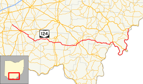
State Route 124 (SR 124) is an east–west state highway in the southern portion of the U.S. state of Ohio. Its western terminus is at State Route 134 nearly 4 miles (6.4 km) southeast of Martinsville, and its eastern terminus is near the unincorporated village of Torch at the concurrency of U.S. Route 50, State Route 7, and State Route 32 in extreme southeastern Athens County. The road passes through numerous villages along its route, many of them economically depressed. State Route 124 has the longest concurrency of state routes in Ohio, running concurrent with State Route 32 for 35½ miles. The road was recently rerouted in 2003 following the extension of U.S. Route 33 to the Ravenswood Bridge.
History
- 1926 – Original route certified; originally routed from Hillsboro to 3 miles (4.8 km) south of Portland along the former State Route 24 alignment.[2]
- 1934 – Extended to Portland.[2]
- 1935 – Extended to 1-mile (1.6 km) east of Coolville along a previously unnumbered road from Portland to Long Bottom, a former alignment of State Route 248 from Long Bottom to Reedsville, a previously unnumbered road from Reedsville to Hockingport, and along the current State Route 144 from Hockingport to 1-mile (1.6 km) east of Coolville.[2]
- 1936 – Rerouted to its current eastern terminus along a previously unnumbered road (this alignment was State Route 144 before 1926); Hockingport to 1-mile (1.6 km) east of Coolville certified as State Route 144.[2]
- 1938 – Extended to its current western terminus along a previously unnumbered road; rerouted from Great Bend to 3 miles (4.8 km) south of Portland along the current State Route 338; former alignment from Great Bend to 3 miles (4.8 km) south of Portland certified as State Route 338.[2]
- 1941 – State Route 124 and State Route 338 alignments from Great Bend to 3 miles (4.8 km) south of Portland reverted to previous and current routings.[2]
- 1934 – Extended to Portland.[2]
- 1969 – Joined with State Route 7 along Pomeroy bypass.[3]
- 1974 – 4 miles (6.4 km) west of Jasper to Jasper upgraded to divided highway.[4]
- 1984 – Joined by State Route 32 from 4 miles (6.4 km) west of Jasper to Roads.[4]
- unknown – Givens to Roads upgraded to divided highway.
- 1997 – Jasper to Givens upgraded to divided highway.[4]
- 2003 – Routed along the former U.S. Route 33 alignment from 2 miles (3.2 km) north of Pomeroy to 1-mile (1.6 km) east of Pomeroy; routed along a former alignment of State Route 338 from Racine to Great Bend; former State Route 124 alignment from Racine to Great Bend decertified.
- 2009 - Routed along Athens County Road 62 (Youba Ridge Rd.) from Hockingport to a new eastern terminus near Torch. The former section from Hockingport to Little Hocking had been permanently closed in 2005 due to a landslide.[5]
Before 1926
- 1924 – Original route established;[6] originally routed from Sharonville to Franklin.[2]
- 1926 – Entire route became a portion of the former U.S. Route 25.[2]
Major junctions
| County | Location | mi[1] | km | Destinations | Notes |
|---|---|---|---|---|---|
| Clinton | Clark Township | 0.00 | 0.00 | ||
| Highland | Hillsboro | 10.38 | 16.70 | Western end of US 50 concurrency | |
| 10.74 | 17.28 | Western end of SR 73 concurrency | |||
| 10.87 | 17.49 | Eastern end of SR 73 concurrency | |||
| 11.30 | 18.19 | Eastern end of US 50 concurrency | |||
| Marshall Township | 18.76 | 30.19 | Western terminus of SR 506 | ||
| Brush Creek Township | 26.86 | 43.23 | Western end of SR 41 concurrency | ||
| Sinking Spring | 27.85 | 44.82 | Eastern end of SR 41 concurrency | ||
| Pike | Sunfish–Pebble township line | 43.01 | 69.22 | Western end of SR 772 concurrency | |
| Newton Township | 45.25 | 72.82 | Eastern end of SR 772 concurrency; western end of SR 32 concurrency | ||
| 48.95 | 78.78 | ||||
| Seal Township | 50.38– 50.51 | 81.08– 81.29 | Interchange | ||
| 53.80 | 86.58 | Eastern terminus of SR 220 | |||
| Marion Township | 61.10 | 98.33 | |||
| Jackson | Scioto Township | 69.11 | 111.22 | ||
| Franklin Township | 72.07 | 115.99 | |||
| Lick Township | 74.34– 74.64 | 119.64– 120.12 | Interchange | ||
| 75.18– 75.66 | 120.99– 121.76 | Interchange | |||
| Milton Township | 80.59– 80.74 | 129.70– 129.94 | Interchange; eastern end of SR 32 concurrency; western end of SR 327 concurrency | ||
| 81.20 | 130.68 | Eastern end of SR 327 concurrency | |||
| Vinton | Wilkesville | 93.36 | 150.25 | Western end of SR 160 concurrency | |
| 96.63 | 155.51 | Eastern end of SR 160 concurrency | |||
| Meigs | Salem Township | 101.56 | 163.44 | Northern terminus of SR 325 | |
| Salisbury Township | 110.73 | 178.20 | Western end of SR 7 concurrency | ||
| 111.76 | 179.86 | Southern terminus of SR 143 | |||
| 114.05– 114.72 | 183.55– 184.62 | Interchange; eastern end of SR 7 concurrency; western end of SR 833 concurrency | |||
| Pomeroy | 116.25 | 187.09 | Western terminus of SR 733 | ||
| 116.49 | 187.47 | Eastern end of SR 833 concurrency | |||
| Lebanon Township | 139.86 | 225.08 | |||
| Olive Township | 151.51 | 243.83 | Eastern terminus of SR 248 | ||
| 156.39 | 251.69 | Eastern terminus of SR 681 | |||
| Athens | Troy Township | 161.61 | 260.09 | Southern terminus of SR 144 | |
| 165.51 | 266.36 | ||||
1.000 mi = 1.609 km; 1.000 km = 0.621 mi
| |||||
References
| Wikimedia Commons has media related to Ohio State Route 124. |
- 1 2 "DESTAPE". Ohio Department of Transportation. July 3, 2014. Retrieved September 7, 2014.
- 1 2 3 4 5 6 7 8 9 Route 124 (The Unofficial Ohio State Highways Web Site) by John Simpson Archived December 27, 2004, at the Wayback Machine.
- ↑ Route 7 (The Unofficial Ohio State Highways Web Site) by John Simpson Archived March 13, 2007, at the Wayback Machine.
- 1 2 3 Route 32 (The Unofficial Ohio State Highways Web Site) by John Simpson Archived May 25, 2005, at the Wayback Machine.
- ↑ http://www.wtap.com/home/headlines/70228362.html
- ↑ Explanation of the Ohio State Highway System (The Unofficial Ohio State Highways Web Site) by John Simpson Archived November 6, 2007, at the Wayback Machine.
This article is issued from Wikipedia - version of the 11/15/2016. The text is available under the Creative Commons Attribution/Share Alike but additional terms may apply for the media files.