Ohio State Route 123
| ||||
|---|---|---|---|---|
 | ||||
| Route information | ||||
| Maintained by ODOT | ||||
| Length: | 43.30 mi[1] (69.68 km) | |||
| Existed: | 1924 – present | |||
| Major junctions | ||||
| South end: |
| |||
|
| ||||
| North end: |
| |||
| Location | ||||
| Counties: | Brown, Clinton, Warren, Montgomery | |||
| Highway system | ||||
| ||||

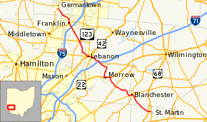
State Route 123 (SR 123) is a state highway in southwestern Ohio. The route runs from SR 251 about seven miles (11 km) southeast of Blanchester to Germantown at SR 4, a distance of 43.30 miles (69.68 km). The section of road from Franklin to Lebanon was originally a toll road until it was taken over by Warren County and made free for public use. [2]

Landmarks
Ohio Historical Marker #2-14 is located on State Route 123 near Blanchester. It commemorates the Garrison Corner Community which was settled by Lemuel Garrison, Sr., and included a school and cemetery.[3]
History
In Lebanon, SR 123 was rerouted to a new roadway, which the city of Lebanon has called "Neil Armstrong Way", from SR 63's (Main Street) intersection with Glosser Road to SR 123's existing intersection with Hart Road. Armstrong for many years owned a farm along SR 123 between Lebanon and the community of Red Lion. The road opened on October 7, 2014. There are also plans to introduce a bill in the state senate to apply the name "Neil Armstrong Way" to the entire stretch of SR 123 from Lebanon to Red Lion.[4][5][6]
Major intersections
| County | Location | mi[1] | km | Destinations | Notes |
|---|---|---|---|---|---|
| Brown | Perry Township | 0.00 | 0.00 | ||
| 0.76 | 1.22 | ||||
| Clinton | Blanchester | 6.91 | 11.12 | Southern end of SR 133 concurrency | |
| 7.03 | 11.31 | Northern end of SR 133 concurrency; southern end of SR 28 concurrency | |||
| Warren | Harlan Township | 7.98 | 12.84 | Northern end of SR 28 concurrency | |
| 12.61 | 20.29 | ||||
| Salem Township | 15.64 | 25.17 | Southern end of US 22 / SR 3 concurrency | ||
| Morrow | 17.37 | 27.95 | Northern end of US 22 / SR 3 concurrency | ||
| Turtle Creek Township | 22.73 | 36.58 | Western terminus of SR 350 | ||
| 22.82– 23.00 | 36.73– 37.01 | Exit 32 (I-71) | |||
| Lebanon | 25.38– 25.53 | 40.85– 41.09 | Interchange; southern end of SR 48 concurrency; southern terminus of unsigned SR 48T | ||
| 26.44 | 42.55 | Southern end of US 42 concurrency; eastern terminus of SR 63 | |||
| 26.59 | 42.79 | Northern end of US 42 / SR 48 concurrencies | |||
| Clearcreek Township | 31.64 | 50.92 | Southern end of SR 122 concurrency | ||
| 31.88 | 51.31 | ||||
| 32.00 | 51.50 | Northern end of SR 122 concurrency | |||
| Franklin | 36.19– 36.28 | 58.24– 58.39 | Exit 36 (I-75) | ||
| 37.49 | 60.33 | Southern end of SR 73 concurrency (on one-way pair) | |||
| 37.84 | 60.90 | Northern end of SR 73 concurrency (on one-way pair) | |||
| Montgomery | German Township | 43.30 | 69.68 | ||
1.000 mi = 1.609 km; 1.000 km = 0.621 mi
| |||||
References
- 1 2 "DESTAPE". Ohio Department of Transportation. July 3, 2014. Retrieved September 7, 2014.
- ↑ "TOWNSHIP PROFILE, HISTORY AND GENERAL CHARACTERISTICS" (PDF). Clear Creek Township. Retrieved 21 February 2014.
- ↑ "Marker #2-14 Garrison Corner Community". The Ohio Historical Society. Retrieved 21 February 2014.
- ↑ Budd, Lawrence (April 3, 2014). "Road to be named for Neil Armstrong". Dayton Daily News. Retrieved September 20, 2014. (subscription required (help)).
- ↑ Budd, Lawrence (August 24, 2014). "Development anticpated [sic] along Neil Armstrong Way". Dayton Daily News. Retrieved April 29, 2015. (subscription required (help)).
- ↑ Budd, Lawrence (October 9, 2014). "Neil Armstrong Way opens for drivers". Dayton Daily News. Retrieved October 13, 2014.