Oak Ridges—Markham
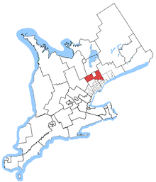 Oak Ridges—Markham is in south-central Ontario, just north of Toronto | |
| Coordinates: |
43°55′45″N 79°31′37″W / 43.92917°N 79.52694°WCoordinates: 43°55′45″N 79°31′37″W / 43.92917°N 79.52694°W Location of the federal district constituency office in King City (as of 26 August 2010) |
| Defunct federal electoral district | |
| Legislature | House of Commons |
| District created | 2003 |
| District abolished | 2013 |
| First contested | 2004 |
| Last contested | 2011 |
| District webpage | profile, map |
| Demographics | |
| Population (2011)[1] | 228,997 |
| Electors (2011) | 151,584 |
| Area (km²)[1] | 679.90 |
| Census divisions | York |
| Census subdivisions | Markham, Richmond Hill, Whitchurch–Stouffville, King |
.png)
Oak Ridges—Markham was a federal electoral district in Ontario, Canada, that was represented in the Canadian House of Commons from 2004 to 2015. Its population in 2006 was 169,645.,[2] with 136,755 electors, the highest of any riding in Canada. By 2011, the riding's population had risen to 228,997, the largest population of all ridings in Canada.[3]
The district covered part of the suburbs north of Toronto. It included the town of Whitchurch–Stouffville, most of the township of King (excepting extreme northeast) the northern portions of the town of Richmond Hill (including all of Oak Ridges), and the northern and eastern portions of the city of Markham.
The electoral district was created in 2004 52.5% from Oak Ridges, 30% from Markham, 13% from Vaughan—King—Aurora, and 4.5% from York North riding.
Following the 2012 federal electoral boundaries redistribution, the district was split between King—Vaughan, Aurora—Oak Ridges—Richmond Hill, Markham—Unionville, and Markham—Stouffville.
Demographics
Communities in Oak Ridges—Markham are the destination for many immigrants to Canada, composing about 41.6% of the population, or about 70,000 of its residents.[2] For 72,440 residents, neither English nor French, the official languages of Canada, is their mother tongue,[2] though most have knowledge of English (148,975), French (160), or both (12,885).[2] Most immigrants become citizens, as 11,155 immigrants were not Canadian citizens as of the Canada 2006 Census.[2]
The primarily urban district has a low proportion of Aboriginal residents compared to other parts of Canada, with just 625 people identifying themselves of such descent.[2] It is also home to 70,070 residents who identify themselves as visible minorities, more than half of which are Chinese Canadians[2] and about 20% are Black Canadians.[2]
At the 2006 census, the participation rate of residents in the work force was 71.3%, and the electoral district unemployment rate was 5%,[2] below the national average of 6.3%.[4]
The district is the second-largest electoral district in Canada by population, next to Brampton West which had 170,422 residents at the 2006 census.[5] It was the 64th largest in 2001, with a population of 111,276,[6] but had the greatest population growth from 2001 to 2006, about 52.5%.[7]
Boundaries
According to Elections Canada, Oak Ridges—Markham consisted of that part of the Regional Municipality of York composed of:
(a) the Town of Whitchurch–Stouffville;
(b) the part of the Township of King south of Highway No. 9;
(c) the part of the Town of Richmond Hill lying north and east of a line drawn from the western town limit east along Gamble Road, south along Yonge Street and east along Elgin Mills Road East to the eastern town limit; and
(d) the part of the City of Markham lying north and east of a line drawn from the western town limit east along 16th Avenue, south along McCowan Road, east along Highway No. 7, and south along 9th Line to the southern town limit.
Members of Parliament
This riding has elected the following member of the Canadian House of Commons:
| Parliament | Years | Member | Party | |
|---|---|---|---|---|
| Oak Ridges—Markham Riding created from Oak Ridges, Markham, Vaughan—King—Aurora and York North |
||||
| 38th | 2004–2006 | Lui Temelkovski | Liberal | |
| 39th | 2006–2008 | |||
| 40th | 2008–2011 | Paul Calandra | Conservative | |
| 41st | 2011–2015 | |||
| Riding dissolved into Markham—Stouffville, King—Vaughan, Markham—Unionville and Aurora—Oak Ridges—Richmond Hill |
||||
Election results
| Canadian federal election, 2011 | ||||||||
|---|---|---|---|---|---|---|---|---|
| Party | Candidate | Votes | % | ∆% | Expenditures | |||
| Conservative | Paul Calandra | 46,241 | 51.12 | +8.88 | $133,192 | |||
| Liberal | Lui Temelkovski | 25,561 | 28.26 | -13.26 | $108,951 | |||
| New Democratic | Janice Hagan | 15,229 | 16.84 | +7.45 | $4,650 | |||
| Green | Trifon Haitas | 2,349 | 2.60 | -4.23 | $0.00 | |||
| Progressive Canadian | John Sicilano | 1,080 | 1.19 | – | $564 | |||
| Total valid votes/Expense limit | 90,460 | 100.00 | – | $134,351 | ||||
| Total rejected ballots | 430 | 0.47 | – | |||||
| Turnout | 90,890 | 59.96 | +4.30 | |||||
| Eligible voters | 151,584 | – | – | |||||
| Conservative hold | Swing | +11.07% | ||||||
| Canadian federal election, 2008 | ||||||||
|---|---|---|---|---|---|---|---|---|
| Party | Candidate | Votes | % | ∆% | Expenditures | |||
| Conservative | Paul Calandra | 32,028 | 42.24 | +3.77 | $112,693 | |||
| Liberal | Lui Temelkovski | 31,483 | 41.52 | -5.53 | $68,266 | |||
| New Democratic | Andy Arifin | 7,126 | 9.39 | -0.49 | $2,020 | |||
| Green | Richard Taylor | 5,184 | 6.83 | +2.24 | $8,063 | |||
| Total valid votes/Expense limit | 75,821 | 100.00 | $120,647 | |||||
| Turnout | 76,111 | 55.66 | -11.23 | |||||
| Conservative gain from Liberal | Swing | +4.65 | ||||||
| Canadian federal election, 2006 | ||||||||
|---|---|---|---|---|---|---|---|---|
| Party | Candidate | Votes | % | ∆% | Expenditures | |||
| Liberal | Lui Temelkovski | 35,048 | 47.05 | -4.68 | $55,610 | |||
| Conservative | Bob Callow | 28,695 | 38.47 | +4.96 | $92,644 | |||
| New Democratic | Pamela Courtot | 7,369 | 9.88 | +1.10 | $8,822 | |||
| Green | Steve Armes | 3,431 | 4.59 | +0.70 | $1,852 | |||
| Total valid votes/Expense limit | 74,543 | 100.00 | $98,012 | |||||
| Turnout | 74,834 | 66.89 | +3.51 | |||||
| Liberal hold | Swing | -4.82 | ||||||
| Canadian federal election, 2004 | ||||||||
|---|---|---|---|---|---|---|---|---|
| Party | Candidate | Votes | % | ∆% | ||||
| Liberal | Lui Temelkovski | 31,964 | 51.73 | -1.34 | ||||
| Conservative | Bob Callow | 20,712 | 33.51 | -9.10 | ||||
| New Democratic | Pamela Courtot | 5,430 | 8.78 | +5.94 | ||||
| Green | Bernadette Manning | 2,406 | 3.89 | |||||
| Progressive Canadian | Jim Conrad | 820 | 1.32 | |||||
| Christian Heritage | Maurice Whittle | 458 | 0.74 | |||||
| Total valid votes | 61,790 | 100.00 | ||||||
| Turnout | 62,145 | 63.38 | ||||||
| Liberal hold | Swing | +3.88 | ||||||
2004 change is based on redistributed results. Conservative change is compared to a combination of Canadian Alliance and Progressive Conservative votes.
Redistribution
Because Oak-Ridges Markham had a population 115.60% over the Ontario quota (Canada's most populous riding) it was substantially affected by the 2012 electoral district redistribution.[8] The district was renamed King—Vaughan, which consists of the Township of King south of Highway 9, along with the part of the City of Vaughan north of Major Mackenzie Drive, west of Highway 400, and north of Rutherford Road east of Hwy 400.[9]
The part that is the town of Whitchurch–Stouffville and in the City of Markham east of Ontario Highway 48 / Main Street Markham/ York Regional Road 68 was incorporated into the new Markham—Stouffville riding.[10] The part in the town of Richmond Hill is part of the new Aurora—Oak Ridges—Richmond Hill riding.[11] Finally, the part in the city of Markham west of the above mentioned roads is part of the new Markham—Unionville riding,[12] which is different from the previous riding of the same name.
References
- "(Code 35059) Census Profile". 2011 census. Statistics Canada. 2012. Retrieved 2011-03-03.
- Oak Ridges—Markham constituency profile at the Parliament of Canada
- 2011 results from Elections Canada
- Electoral district profile Oak Ridges--Markham (Ontario)
- Campaign expense data from Elections Canada
Notes
- 1 2 Statistics Canada: 2012
- 1 2 3 4 5 6 7 8 9 "Federal Electoral District Profile of Oak Ridges — Markham, Ontario (2003 Representation Order), 2006 Census". Statistics Canada. Retrieved 2010-04-04.
- ↑ Census Canada, Population and dwelling counts, for Canada and federal electoral districts, 2006; National Post, Canada Census 2011: Harper could reap the benefits as census suggests new ridings, February 8, 2012.
- ↑ "Work — Unemployment Rate". Human Resources and Skills Development Canada. Retrieved 2010-04-04.
- ↑ "Population and dwelling counts, for Canada and federal electoral districts (2003 Representation Order), 2006 and 2001 censuses - 100% data (sorted by 2006 population)". Federal electoral districts (FEDs) – 2003 Representation Order. Statistics Canada. Retrieved 2010-04-04.
- ↑ "Population and dwelling counts, for Canada and federal electoral districts (2003 Representation Order), 2006 and 2001 censuses - 100% data (sorted by 2001 population)". Federal electoral districts (FEDs) – 2003 Representation Order. Statistics Canada. Retrieved 2010-04-04.
- ↑ "Population and dwelling counts, for Canada and federal electoral districts (2003 Representation Order), 2006 and 2001 censuses - 100% data (sorted by population growth)". Federal electoral districts (FEDs) – 2003 Representation Order. Statistics Canada. Retrieved 2010-04-04.
- ↑ Proposed Boundaries – Ontario
- ↑ Oak Ridges – Proposed Boundaries
- ↑ Markham—Stouffville – Proposed Boundaries
- ↑ Aurora—Richmond Hill – Proposed Boundaries
- ↑ Markham—Unionville – Proposed Boundaries
External links
- Oak Ridges—Markham at Parliament of Canada