| [2] |
Name on the Register[3] |
Image |
Date listed[4] |
Location |
City or town |
Description |
|---|
| 1 |
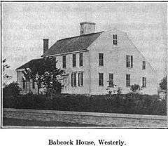
Babcock-Smith House |
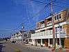
|
000000001972-07-24-0000July 24, 1972
(#72000008) |
124 Granite St.
41°22′16″N 71°49′13″W / 41.371111°N 71.820278°W / 41.371111; -71.820278 (Babcock-Smith House) |
Westerly |
|
| 2 |
Bradford Village Historic District |
Upload image |
000000001996-05-30-0000May 30, 1996
(#96000573) |
Roughly Bowling Ln. from the Pawcatuck River to Vars Ln. and Main St. from the Bradford Bridge to Church Ave.
41°24′08″N 71°45′06″W / 41.402222°N 71.751667°W / 41.402222; -71.751667 (Bradford Village Historic District) |
Hopkinton and Westerly |
|
| 3 |
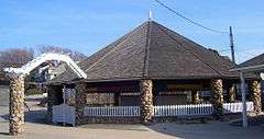
Flying Horse Carousel |
|
000000001980-01-11-0000January 11, 1980
(#80000019) |
Bay St.
41°18′32″N 71°51′31″W / 41.308889°N 71.858611°W / 41.308889; -71.858611 (Flying Horse Carousel) |
Westerly |
One of the earliest carousels still in use, dating to 1876. Horses suspended from chains rather than on poles, hence name.
|
| 4 |
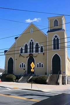
Former Immaculate Conception Church |
|
000000001973-04-24-0000April 24, 1973
(#73000007) |
119 High St.
41°22′55″N 71°49′32″W / 41.381944°N 71.825556°W / 41.381944; -71.825556 (Former Immaculate Conception Church) |
Westerly |
|
| 5 |
Lewis-Card-Perry House |
Upload image |
000000002005-10-04-0000October 4, 2005
(#05001152) |
12 Margin St.
41°22′08″N 71°49′57″W / 41.368789°N 71.832467°W / 41.368789; -71.832467 (Lewis-Card-Perry House) |
Westerly |
|
| 6 |
Main Street Historic District |
Upload image |
000000001978-01-09-0000January 9, 1978
(#78000021) |
113-132 Main St., 8, 7-13 School St., 3-14 Maple St.
41°22′25″N 71°49′51″W / 41.373611°N 71.830833°W / 41.373611; -71.830833 (Main Street Historic District) |
Westerly |
|
| 7 |
North End Historic District |
Upload image |
000000002006-04-20-0000April 20, 2006
(#06000298) |
Canal, Dayton, Friendship, High, Pearl, Pierce, Pleasant, Pond, West, Industrial Lila, Geranium, Marriott and Turano
41°23′16″N 71°49′38″W / 41.387778°N 71.827222°W / 41.387778; -71.827222 (North End Historic District) |
Westerly |
|
| 8 |
Nursery Site, RI-273 |
Upload image |
000000001984-11-01-0000November 1, 1984
(#84000386) |
Address Restricted
|
Westerly |
|
| 9 |
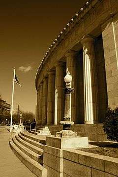
US Post Office |
|
000000001971-08-12-0000August 12, 1971
(#71000004) |
High and Broad Sts.
41°22′39″N 71°49′50″W / 41.3775°N 71.830556°W / 41.3775; -71.830556 (US Post Office) |
Westerly |
|
| 10 |
Watch Hill Historic District |
|
000000001985-09-05-0000September 5, 1985
(#85001948) |
Roughly bounded by Breen, Watch Hill, and E. Hill Rds., Block Island Sound, Little Narragansett Bay, and the Pawtucket River
41°18′49″N 71°51′23″W / 41.313611°N 71.856389°W / 41.313611; -71.856389 (Watch Hill Historic District) |
Westerly |
Well-preserved Victorian seaside resort area
|
| 11 |
Weekapaug Inn |
Upload image |
000000002007-01-25-0000January 25, 2007
(#06001305) |
25 Spray Rock Rd.
41°19′49″N 71°45′03″W / 41.330278°N 71.750833°W / 41.330278; -71.750833 (Weekapaug Inn) |
Westerly |
|
| 12 |
Westerly Armory |
|
000000001996-11-07-0000November 7, 1996
(#96001322) |
Railroad Ave., west of downtown Westerly
41°22′55″N 71°49′40″W / 41.381944°N 71.827778°W / 41.381944; -71.827778 (Westerly Armory) |
Westerly |
|
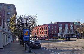
| 13 |
Westerly Downtown Historic District |
|
000000001984-07-19-0000July 19, 1984
(#84002055) |
Railroad Ave., High, Canal, Broad, Union, and Main Sts.
41°22′45″N 71°49′49″W / 41.379167°N 71.830278°W / 41.379167; -71.830278 (Westerly Downtown Historic District) |
Westerly |
|
| 14 |
Wilcox Park Historic District |
|
000000001973-05-07-0000May 7, 1973
(#73000011) |
Roughly bounded by Broad, Granite, High Sts. and Grove Ave. and running along Elm St.
41°22′36″N 71°49′43″W / 41.376667°N 71.828611°W / 41.376667; -71.828611 (Wilcox Park Historic District) |
Westerly |
|

_-_Westerly%2C_RI.JPG)
_(extra_close)_(US48).svg.png)