| [2] |
Name on the Register[3] |
Image |
Date listed[4] |
Location |
City or town |
Description |
|---|
| 1 |
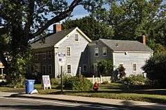
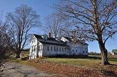
Arnold Mills Historic District |
|
000000001978-12-28-0000December 28, 1978
(#78000070) |
East of Cumberland Hill at Sneech Pond, Attleboro, and Abbott Run Valley Rds.
41°58′46″N 71°23′30″W / 41.979444°N 71.391667°W / 41.979444; -71.391667 (Arnold Mills Historic District) |
Cumberland |
|
| 2 |
Ashton Historic District |
|
000000001984-11-01-0000November 1, 1984
(#84000367) |
Roughly Mendon, Scott, and Old Angell Rds., Store Hill Rd., Front and Middle Sts.
41°56′20″N 71°25′54″W / 41.938889°N 71.431667°W / 41.938889; -71.431667 (Ashton Historic District) |
Cumberland |
|
| 3 |
Ballou-Weatherhead House |
|
000000001993-06-25-0000June 25, 1993
(#93000503) |
Tower Hill Rd. (Pole 68)
41°59′47″N 71°26′38″W / 41.996389°N 71.443889°W / 41.996389; -71.443889 (Ballou-Weatherhead House) |
Cumberland |
|
| 4 |
Berkeley Mill Village |
|
000000001972-02-23-0000February 23, 1972
(#72000036) |
Bounded roughly by Martin St., Mendon Rd., railroad, and cemetery
41°55′39″N 71°25′25″W / 41.9275°N 71.423611°W / 41.9275; -71.423611 (Berkeley Mill Village) |
Cumberland |
|
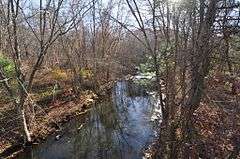
| 5 |
Blackstone Canal |
|
000000001971-05-06-0000May 6, 1971
(#71000030) |
From Steeple and Promenade Sts. in Providence to the Massachusetts border in North Smithfield
41°55′16″N 71°25′21″W / 41.921111°N 71.4225°W / 41.921111; -71.4225 (Blackstone Canal) |
Lincoln, Cumberland, Woonsocket, and North Smithfield |
Initial listing extended from Providence, through Pawtucket, and as far north as Lincoln; a 1991 expansion (#91001536) extended it to the state line; the canal itself extended into Worcester County, Massachusetts, where it is the subject of separate listings.
|
| 6 |
Burlingame-Noon House |
|
000000001974-02-15-0000February 15, 1974
(#74000048) |
3261 Mendon Rd.
41°58′32″N 71°27′25″W / 41.975556°N 71.456944°W / 41.975556; -71.456944 (Burlingame-Noon House) |
Cumberland |
|
| 7 |
John Cole Farm |
|
000000001977-08-16-0000August 16, 1977
(#77000025) |
East of Manville on Reservoir Rd.
41°59′26″N 71°24′24″W / 41.990556°N 71.406667°W / 41.990556; -71.406667 (John Cole Farm) |
Cumberland |
|
| 8 |
Furnace Carolina Site |
|
000000001993-05-10-0000May 10, 1993
(#93000341) |
Address Restricted
|
Cumberland |
|
| 9 |
Luke Jillson House |
|
000000001982-08-12-0000August 12, 1982
(#82000141) |
2510 Mendon Rd.
41°57′41″N 71°26′41″W / 41.961389°N 71.444722°W / 41.961389; -71.444722 (Luke Jillson House) |
Cumberland |
|
| 10 |
Lonsdale Historic District |
|
000000001984-05-25-0000May 25, 1984
(#84002022) |
Lonsdale Ave., Blackstone Ct., and Front, Main, Cook, Broad, Mill, Cross and Blackstone Sts.
41°54′34″N 71°24′11″W / 41.909444°N 71.403056°W / 41.909444; -71.403056 (Lonsdale Historic District) |
Cumberland and Lincoln |
|
| 11 |
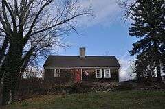
Metcalf-Franklin Farm |
|
000000002007-06-07-0000June 7, 2007
(#07000526) |
142 Abbott Run Valley Rd.
41°57′56″N 71°23′37″W / 41.965622°N 71.393511°W / 41.965622; -71.393511 (Metcalf-Franklin Farm) |
Cumberland |
|
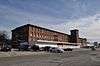
| 12 |
Patterson Brothers Commercial Building and House |
|
000000001993-06-10-0000June 10, 1993
(#93000502) |
157, 159, and 161 Broad St.
41°54′10″N 71°23′32″W / 41.902778°N 71.392222°W / 41.902778; -71.392222 (Patterson Brothers Commercial Building and House) |
Cumberland |
Demolished 1998. Hardware store stands on the site.[5]
|
| 13 |
St. Joseph's Church Complex |
|
000000001982-08-12-0000August 12, 1982
(#82000007) |
1303-1317 Mendon Rd.
41°56′03″N 71°25′40″W / 41.934167°N 71.427778°W / 41.934167; -71.427778 (St. Joseph's Church Complex) |
Cumberland |
|
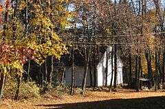
| 14 |
Lewis Tower House |
|
000000001982-08-30-0000August 30, 1982
(#82000010) |
2199 Mendon Rd.
41°57′14″N 71°26′33″W / 41.953889°N 71.4425°W / 41.953889; -71.4425 (Lewis Tower House) |
Cumberland |
|
| 15 |
Tower-Flagg Barn Complex |
Upload image |
000000001998-05-20-0000May 20, 1998
(#98000574) |
100 Abbott Run Valley Rd.
41°57′33″N 71°23′34″W / 41.959167°N 71.392778°W / 41.959167; -71.392778 (Tower-Flagg Barn Complex) |
Cumberland |
Demolished and replaced by housing development.
|
| 16 |
Whipple-Jenckes House |
|
000000001992-11-05-0000November 5, 1992
(#92001541) |
8 Fairhaven Road
41°57′25″N 71°24′02″W / 41.957057°N 71.400437°W / 41.957057; -71.400437 (Whipple-Jenckes House) |
Cumberland |
|


_(extra_close)_(US48).svg.png)