Blackstone River
| Blackstone River | |
|---|---|
|
The Blackstone River in Blackstone, Massachusetts, just short of the Rhode Island border. | |
 | |
| Country | United States |
| City | Massachusetts, Rhode Island |
| Basin | |
| Main source | Worcester, MA |
| River mouth |
Seekonk River, at Pawtucket Falls in Pawtucket, Rhode Island 41°52′38″N 71°22′56″W / 41.8771°N 71.3822°WCoordinates: 41°52′38″N 71°22′56″W / 41.8771°N 71.3822°W |
| Basin size | 540 sq mi (1,400 km2) |
| Physical characteristics | |
| Length | 48 mi (77 km) |

The Blackstone River is a river in the U.S. states of Massachusetts and Rhode Island. It flows approximately 48 mi (80 km) and drains a watershed of approximately 540 sq. mi (1,400 km²). Its long history of industrial use has left a legacy of pollution, and was characterized by the United States Environmental Protection Agency in 1990 as "the most polluted river in the country with respect to toxic sediments."[1]
History

The river is named after William Blackstone (original spelling William Blaxton) who arrived in Weymouth, Massachusetts in 1623, and became the first settler of present-day Boston in 1625. He relocated again, to Rhode Island in 1635 and built his home on the river, in what would become Cumberland. With the Providence River, the Blackstone was the northeastern border of Dutch claims for New Netherland from Adriaen Block's charting of Narragansett Bay in 1614 through the Hartford Treaty of 1650.
The original Native American name for the river was the "Kittacuck", which meant "the great tidal river". The "Kittacuck", or Blackstone, was plentiful with Salmon and Lamprey in pre-colonial and colonial times.[2]
In 1790, Samuel Slater opened the first successful water powered cotton mill in America, Slater Mill, at Pawtucket Falls. This mill was powered by the waters of the Blackstone River. Many other mills appeared along the Blackstone River over time making it an important part of American industry. The industrialization also led to the river being identified by the end of the 20th century as the primary source of Narragansett Bay pollution.[3]
In August 1955, severe flooding on the Blackstone caused extensive damage to Woonsocket, Rhode Island. Where the river is usually 70 feet (21 m) wide it swelled to over 1 mile (1.6 km) wide. The flooding of the Blackstone was the result of a succession of dam breaks and was caused by rainfall from Hurricane Connie followed a week later by Hurricane Diane, which together deposited over 20 inches (510 mm) of rain in parts of Rhode Island and Massachusetts.[4] The Blackstone river reached a stage of 21.8 feet (6.6 m) in Woonsocket, which remains the flood of record; flood stage is 9.0 feet (2.7 m).[5]
The river, together with the Woonasquatucket River to the south, was designated an American Heritage River in 1998.
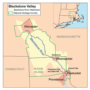
Course
The river is formed in Worcester, Massachusetts by the confluence of the Middle River and Mill Brook. From there, it follows a rough southeast course through Millbury, Sutton, Grafton, Northbridge, Uxbridge, Millville, and Blackstone. It then continues into Rhode Island, where it flows through Woonsocket, Cumberland, Lincoln, Central Falls, and Pawtucket, where the river then reaches Pawtucket Falls. After that, the river becomes tidal, and changes its name to the Seekonk River. Other tributaries join the Blackstone along the way, such as the West and Mumford River, at Uxbridge, and The Branch River in North Smithfield.
Pollution and remediation efforts
The Blackstone River has a long association with industry, and a legacy of pollution as a result. By 1900 the river was already considered polluted and the Massachusetts Department of Public Health said in a report, "The Department finds that the condition of the Blackstone River is offensive throughout its course, from Worcester to the state line at Blackstone. The condition of the stream is likely to grow worse until effective measures are completed for removing from the river much of the pollution which it now receives."[6] Little was actually done to abate this pollution for the next 72 years, until the passage of the Clean Water Act began to spur some action on the part of States and the Federal Government to clean up polluted rivers and streams. Progress was slow, and as recently as 1990, the United States Environmental Protection Agency called the Blackstone, "The most polluted river in the country with respect to toxic sediments."[1]
Early industries discharged a variety of pollutants into the river including dyes from textile mills and heavy metals and solvents from metal and woodworking industries.[6] Much of this early pollution lies trapped in sediments behind historic dams on the river and continues to affect the ecosystem today. Much recent pollution can be traced to the Upper Blackstone Water Pollution Abatement District (UBWPAD), the wastewater treatment plant for Worcester, Massachusetts and surrounding communities, which discharges into the Blackstone. A 2005 report written by the Rhode Island Department of Environmental Management said, ". . . [the] UBWPAD, North Attleboro, and Attleboro WWTFs play a significant role in the ability to improve water quality in the Providence and Seekonk River system [into which the Blackstone discharges], and efforts to reduce their nitrogen inputs should be initiated as soon as possible."[7] In September 2010, the Conservation Law Foundation, citing this report, filed a lawsuit claiming that the discharge permit issued to the UBWPAD by the Environmental Protection Agency is not "sufficient to meet state water quality standards."[8]
River cleanup is still underway, and today the Blackstone is considered a Class C river (suitable only for "secondary contact" activities like boating) for much of its length.[9]
Crossings

Below is a list of all crossings over the Blackstone River. The list starts at the headwaters and goes downstream.
- Worcester
- Millbury
- Southwest Cutoff (U.S. 20)
- Access Road
- Interstate 90
- Main Street
- Massachusetts State Route 146
- MA 146 Ramp to Main Street
- Waters Street
- Elm Street
- South Main Street
- Providence Street (MA 122A)
- Riverlin Street
- Sutton
- Blackstone Street
- Depot Street
- Grafton
- Pleasant Street
- Main Street (MA 122A)
- Depot Street
- Northbridge
- Sutton Street
- Providence Road (MA 122)
- Elston Avenue
- Church Street Extension
- Uxbridge
- East Hartford Avenue
- Mendon Street (MA 16)
- Millville Road (MA 122)
- Millville
- Central Street
- Cam's Street
- Blackstone
- Bridge Street
- St. Paul Street
- Woonsocket
- Singleton Street
- River Street
- Fairmount Street
- Sayles Street
- South Main Street (RI 104)
- Bernon Street
- Court Street (RI 122)
- Hamlet Avenue (RI 122/126)
- Rhode Island State Route 99
- Cumberland
- Manville Hill Road
- School Street
- Interstate 295
- George Washington Highway (RI 116)
- Blackstone River Bikeway
- Martin Street
- Lonsdale Avenue (RI 122)
- John Street (RI 123)
- Central Falls
- Broad Street (RI 114)
- Roosevelt Avenue
- Cross Street
- Pawtucket
- Exchange Street (RI 15/114 Southbound)
Tributaries
In addition to many unnamed tributaries, the following brooks and rivers feed the Blackstone:
- Worcester Aqueduct
- Dorothy Brook
- Cronin Brook
- Quinsigamond River
- Mumford River
- West River
- Still Corner Brook
- Emerson Brook
- Bacon Brook
- Aldrich Brook
- Ironstone Brook
- Branch River
- Fox Brook
- Cherry Brook
- Mill River
- Peters River
- Crookfall Brook
- West Sneech Brook
- Monastery Brook
- Abbott Run
See also
- List of rivers in Massachusetts
- List of rivers in Rhode Island
- Blackstone River Valley National Historical Park
- Blackstone River and Canal Heritage State Park
- Blackstone Valley
- Seekonk River
- Woonasquatucket River
- Ten Mile River (Seekonk River)
- William Blaxton
Notes
- 1 2 "Blackstone River Watershed". Rhode Island Rivers Council. Retrieved 2010-12-28.
- ↑ source document: Metcalf, Annals of the History of Mendon, 1880.
- ↑ Blackstone River Watershed – Five-Year Watershed Action Plan, First Draft Archived March 3, 2007, at the Wayback Machine.
- ↑ "The Floods of Hurricane Connie and Diane". National Weather Service. Retrieved 2011-02-23.
- ↑ "Blackstone River Hydrograph". National Weather Service - Advanced Hydrologic Prediction Service. Retrieved 2011-02-23.
- 1 2 Kerr, Meg (1990). "Rhode Island Sea Grant Fact Sheet: The Blackstone River". Retrieved 2010-12-29.
- ↑ "Plan for Managing Nutrient Loadings to Rhode Island Waters" (PDF). Rhode Island Department of Environmental Management. 2005-02-01. Retrieved 2010-12-29.
- ↑ "Conservation Law Foundation Seeks Stricter Controls on Nitrogen Pollution in Upper Blackstone Water Pollution Abatement District to Restore Water Quality in Massachusetts and Rhode Island". 2010-09-28. Retrieved 2010-12-29.
- ↑ BLACKSTONE RIVER WATERSHED 2003 - 2007 WATER QUALITY ASSESSMENT REPORT (PDF), Massachusetts Department of Environmental Protection Division of Watershed Management, March 2010, pp. xi, retrieved 2010-12-29
References
- Maps from the United States Geological Survey
External links
| Wikimedia Commons has media related to Blackstone River. |
- Providence Journal video of the Blackstone River
- Various Views Along the Blackstone River
- YouTube video of various still photos from the 1955 flood
| Islands |  | |
|---|---|---|
| Major rivers | ||
| Cities & towns | ||
| Bridges | ||
| Rivers | ||
|---|---|---|