National Register of Historic Places listings in Scituate, Rhode Island
This is a list of Registered Historic Places in Scituate, Rhode Island.
- This National Park Service list is complete through NPS recent listings posted December 2, 2016.[1]
| [2] |
Name on the Register[3] |
Image |
Date listed[4] |
Location |
City or town |
Description |
|---|
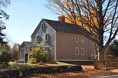
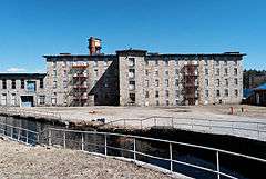
| 1 |
Andrews-Luther Farm |
|
000000001985-06-19-0000June 19, 1985
(#85001352) |
Elmdale Rd.
41°51′08″N 71°36′04″W / 41.852222°N 71.601111°W / 41.852222; -71.601111 (Andrews-Luther Farm) |
Scituate |
|
| 2 |
Dexter Arnold Farmstead |
|
000000001977-11-25-0000November 25, 1977
(#77001586) |
Chopmist Hill Rd.
41°48′59″N 71°39′54″W / 41.816389°N 71.665°W / 41.816389; -71.665 (Dexter Arnold Farmstead) |
Scituate |
|
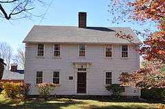
| 3 |
Battey-Barden House |
|
000000001980-08-29-0000August 29, 1980
(#80000084) |
Plainfield Pike
41°47′30″N 71°37′08″W / 41.791667°N 71.618889°W / 41.791667; -71.618889 (Battey-Barden House) |
Scituate |
|
| 4 |
Clayville Historic District |
|
000000001988-12-29-0000December 29, 1988
(#88003079) |
Roughly bounded by Cole Ave., Plainfield Pike, Field Hill Rd., and Victory Highway
41°46′37″N 71°40′35″W / 41.776944°N 71.676389°W / 41.776944; -71.676389 (Clayville Historic District) |
Foster and Scituate |
|
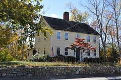
| 5 |
Amos Cooke House |
|
000000001979-10-30-0000October 30, 1979
(#79000054) |
Chopmist Hill Rd.
41°48′31″N 71°39′41″W / 41.808611°N 71.661389°W / 41.808611; -71.661389 (Amos Cooke House) |
Scituate |
|
| 6 |
Double L Site, RI-958 |
Upload image |
000000001985-09-12-0000September 12, 1985
(#85002362) |
Address Restricted
|
Scituate |
|
| 7 |
Hope Village Historic District |
|
000000001995-08-08-0000August 8, 1995
(#95000918) |
Roughly bounded by the Pawtuxet River, Hope Furnace Rd., Hope Mill Pond, North Rd., White Ln., and Harrington and Potter Sts.
41°44′00″N 71°33′45″W / 41.733333°N 71.5625°W / 41.733333; -71.5625 (Hope Village Historic District) |
Scituate |
|
| 8 |
McGonagle Site, RI-1227 |
Upload image |
000000001985-09-12-0000September 12, 1985
(#85002400) |
Address Restricted
|
Scituate |
|
| 9 |
Millrace Site, RI-1039 |
Upload image |
000000001985-09-12-0000September 12, 1985
(#85002361) |
Address Restricted
|
Scituate |
|
| 10 |
Moswansicut Pond Site, RI-960 |
Upload image |
000000001985-09-12-0000September 12, 1985
(#85002363) |
Address Restricted
|
Scituate |
|
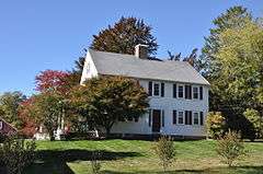
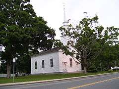
| 11 |
Old Congregational Church |
|
000000001974-01-11-0000January 11, 1974
(#74000002) |
Off U.S. Route 6 on Greenville Rd. (RI 116)
41°50′03″N 71°35′14″W / 41.834167°N 71.587222°W / 41.834167; -71.587222 (Old Congregational Church) |
Scituate |
|
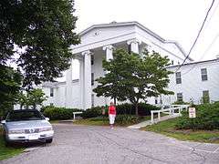
| 12 |
Smithville Seminary |
|
000000001978-03-29-0000March 29, 1978
(#78003446) |
Institute Lane
41°50′02″N 71°35′00″W / 41.833889°N 71.583333°W / 41.833889; -71.583333 (Smithville Seminary) |
Scituate |
|
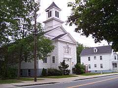
| 13 |
Smithville-North Scituate |
|
000000001979-08-29-0000August 29, 1979
(#79000003) |
Danielson Pike and W. Greenville Road
41°50′00″N 71°35′07″W / 41.833333°N 71.585278°W / 41.833333; -71.585278 (Smithville-North Scituate) |
Scituate |
|
See also
References
|
|---|
|
| Topics | | |
|---|
|
| Lists by county | |
|---|
|
| Lists by city | Bristol Coutny | |
|---|
| Kent County | |
|---|
| Newport County | |
|---|
| Providence County | |
|---|
| Washington County | |
|---|
|
|---|
|
-
 Category Category
-
 NRHP portal NRHP portal
- Massachusetts portal
|
|Scituate]]

_(extra_close)_(US48).svg.png)