National Register of Historic Places listings in Johnston, Rhode Island
This is a list of Registered Historic Places in Johnston, Rhode Island.
- This National Park Service list is complete through NPS recent listings posted December 2, 2016.[1]
| [2] |
Name on the Register[3] |
Image |
Date listed[4] |
Location |
City or town |
Description |
|---|
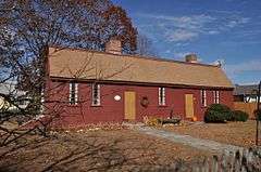
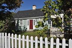
| 1 |
Daniel Angell House |
|
000000001975-04-21-0000April 21, 1975
(#75000056) |
15 Dean Ave.
41°52′46″N 71°30′01″W / 41.879444°N 71.500278°W / 41.879444; -71.500278 (Daniel Angell House) |
Johnston |
|
| 2 |
Belknap School |
|
000000002010-12-07-0000December 7, 2010
(#10000978) |
509 Greenville Ave.
41°50′48″N 71°30′05″W / 41.846667°N 71.501389°W / 41.846667; -71.501389 (Belknap School) |
Johnston |
|
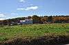
| 3 |
Brown Avenue Historic District |
|
000000001973-04-24-0000April 24, 1973
(#73000066) |
Brown Ave.
41°50′44″N 71°32′37″W / 41.845556°N 71.543611°W / 41.845556; -71.543611 (Brown Avenue Historic District) |
Johnston |
|
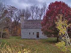
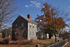
| 4 |
Clemence-Irons House |
|
000000001973-07-02-0000July 2, 1973
(#73000068) |
38 George Waterman Rd.
41°50′21″N 71°29′04″W / 41.839167°N 71.484444°W / 41.839167; -71.484444 (Clemence-Irons House) |
Johnston |
|
| 5 |
Cornell-Randall-Bailey Roadhouse |
|
000000001984-05-10-0000May 10, 1984
(#84001943) |
2737 Hartford Ave.
41°49′57″N 71°33′29″W / 41.8325°N 71.558056°W / 41.8325; -71.558056 (Cornell-Randall-Bailey Roadhouse) |
Johnston |
|
| 6 |
Eddy Homestead |
|
000000001986-08-13-0000August 13, 1986
(#86001511) |
2543 Hartford Ave.
41°49′57″N 71°32′56″W / 41.8325°N 71.548889°W / 41.8325; -71.548889 (Eddy Homestead) |
Johnston |
|
| 7 |
Edwin H. Farnum House |
|
000000001974-05-17-0000May 17, 1974
(#74000359) |
U.S. Route 44 at its junction with Collins St.
41°51′46″N 71°29′39″W / 41.862778°N 71.494167°W / 41.862778; -71.494167 (Edwin H. Farnum House) |
Johnston |
|
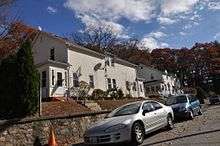
| 8 |
Greystone Historic District |
|
000000002008-01-02-0000January 2, 2008
(#07001343) |
1-16 Beckside Rd., 1-29 Greystone Ave., 1-24 Oakleigh Ave., 1-40 Langsberries Ave., 2-20 Larchmount Ave N, 1-16 S...
41°52′02″N 71°29′24″W / 41.867222°N 71.49°W / 41.867222; -71.49 (Greystone Historic District) |
North Providence and Johnston |
Mill complex and associated village and housing area
|
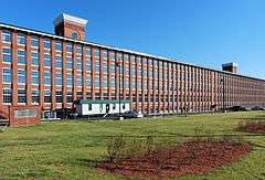
| 9 |
Greystone Mill Historic District |
|
000000002004-04-28-0000April 28, 2004
(#04000378) |
Greystone Ave.
41°51′53″N 71°29′28″W / 41.864722°N 71.491111°W / 41.864722; -71.491111 (Greystone Mill Historic District) |
North Providence and Johnston |
Mill complex along the Woonasquatucket River
|
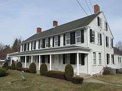
| 10 |
Thomas H. Hughes House |
|
000000001979-06-15-0000June 15, 1979
(#79000056) |
423 Central Ave.
41°48′28″N 71°29′51″W / 41.807778°N 71.4975°W / 41.807778; -71.4975 (Thomas H. Hughes House) |
Johnston |
|
| 11 |
Mathewson Farm |
|
000000002001-01-26-0000January 26, 2001
(#01000019) |
544 Greenville Ave.
41°50′44″N 71°30′16″W / 41.845556°N 71.504444°W / 41.845556; -71.504444 (Mathewson Farm) |
Johnston |
|
| 12 |
Ochee Spring Quarry |
|
000000001978-05-05-0000May 5, 1978
(#78000003) |
Behind 767 Hartford Ave[5]
41°49′14″N 71°28′17″W / 41.820487°N 71.471441°W / 41.820487; -71.471441 (Ochee Spring Quarry) |
Johnston |
This site has been significantly encroached on by local development.
|
| 13 |
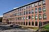
Pocasset Worsted Company Mill |
|
000000002010-07-19-0000July 19, 2010
(#10000471) |
75 Pocasset St.
41°47′50″N 71°28′34″W / 41.797222°N 71.476111°W / 41.797222; -71.476111 (Pocasset Worsted Company Mill) |
Johnston |
|
See also
References
|
|---|
|
| Topics | | |
|---|
|
| Lists by county | |
|---|
|
| Lists by city | Bristol Coutny | |
|---|
| Kent County | |
|---|
| Newport County | |
|---|
| Providence County | |
|---|
| Washington County | |
|---|
|
|---|
|
-
 Category Category
-
 NRHP portal NRHP portal
- Massachusetts portal
|


_(extra_close)_(US48).svg.png)