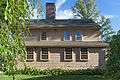
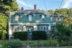
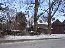
National Register of Historic Places listings in Smithfield, Rhode Island

This is a list of Registered Historic Places in Smithfield, Rhode Island.

Contents: Counties in Rhode Island
This National Park Service list is complete through NPS recent listings posted December 2, 2016.[1]
[2] Name on the Register[3] Image Date listed[4] Location City or town Description
1 Allenville Mill Storehouse
Allenville Mill Storehouse
January 20, 1972
(#72000033)
5 Esmond St.
41°52′41″N 71°30′09″W / 41.878056°N 71.5025°W / 41.878056; -71.5025 (Allenville Mill Storehouse)
Smithfield
2 Angell-Ballou House
Angell-Ballou House
March 18, 2004
(#04000196)
49 Ridge Rd.
41°53′42″N 71°30′05″W / 41.895°N 71.501389°W / 41.895; -71.501389 (Angell-Ballou House)
Smithfield
3 Georgiaville Historic District
Georgiaville Historic District
October 3, 1985
(#85002734)
Roughly bounded by Stillwater Rd., Cross St., Whipple Ave., and Farnum Pike
41°53′18″N 71°30′26″W / 41.888333°N 71.507222°W / 41.888333; -71.507222 (Georgiaville Historic District)
Smithfield
4 Saint Thomas Episcopal Church and Rectory
Saint Thomas Episcopal Church and Rectory
July 2, 1987
(#87000993)
Putnam Pike
41°52′16″N 71°33′12″W / 41.871111°N 71.553333°W / 41.871111; -71.553333 (Saint Thomas Episcopal Church and Rectory)
Smithfield
5 Smith-Appleby House
Smith-Appleby House
May 1, 1974
(#74000005)
Stillwater Rd. southeast of its junction with Capron Rd.
41°54′07″N 71°31′06″W / 41.901944°N 71.518333°W / 41.901944; -71.518333 (Smith-Appleby House)
Smithfield
6 Smithfield Exchange Bank
Smithfield Exchange Bank
April 19, 2006
(#06000295)
599 Putnam Pike
41°52′26″N 71°33′12″W / 41.873889°N 71.553333°W / 41.873889; -71.553333 (Smithfield Exchange Bank)
Smithfield
7 Ira B. Sweet House
Ira B. Sweet House
January 15, 2010
(#08000715)
38 Esmond St.
41°52′31″N 71°30′13″W / 41.875369°N 71.503639°W / 41.875369; -71.503639 (Ira B. Sweet House)
Smithfield
8 Waterman-Winsor Farm
Waterman-Winsor Farm
June 27, 1980
(#80000012)
79 Austin Ave.
41°52′55″N 71°33′45″W / 41.881944°N 71.5625°W / 41.881944; -71.5625 (Waterman-Winsor Farm)
Smithfield
9 Stephen Winsor House
Stephen Winsor House
October 6, 1975
(#75000004)
113 Austin Ave.
41°53′08″N 71°33′55″W / 41.885502°N 71.565378°W / 41.885502; -71.565378 (Stephen Winsor House)
Smithfield Listed at 93 Austin Ave.
10 Woonasquatucket River Site (RI-163)
Woonasquatucket River Site (RI-163)
November 1, 1984
(#84000364)
near Farnum Pike[5]
41°54′33″N 71°32′21″W / 41.90924°N 71.539285°W / 41.90924; -71.539285 (Woonasquatucket River Site (RI-163))
Smithfield

See also

References

  1. "National Register of Historic Places: Weekly List Actions". National Park Service, United States Department of the Interior. Retrieved on December 2, 2016.
  2. Numbers represent an ordering by significant words. Various colorings, defined here, differentiate National Historic Landmarks and historic districts from other NRHP buildings, structures, sites or objects.
  3. National Park Service (2009-03-13). "National Register Information System". National Register of Historic Places. National Park Service.
  4. The eight-digit number below each date is the number assigned to each location in the National Register Information System database, which can be viewed by clicking the number.
  5. "Smithfield Reconnaissance Report" (PDF). National Park Service. Retrieved 2013-11-02.

|Smithfield]]

This article is issued from Wikipedia - version of the 4/22/2016. The text is available under the Creative Commons Attribution/Share Alike but additional terms may apply for the media files.