National Register of Historic Places listings in Richmond County, North Carolina
This list includes properties and districts listed on the National Register of Historic Places in Richmond County, North Carolina. Click the "Map of all coordinates" link to the right to view a Google map of all properties and districts with latitude and longitude coordinates in the table below.[1]
Current listings
- This National Park Service list is complete through NPS recent listings posted December 2, 2016.[2]
| [3] |
Name on the Register |
Image |
Date listed[4] |
Location |
City or town |
Description |
|---|
| 1 |
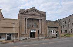
Bank of Pee Dee Building |
|
000000001983-09-22-0000September 22, 1983
(#83001905) |
201 E. Washington St.
34°56′24″N 79°46′25″W / 34.94°N 79.773611°W / 34.94; -79.773611 (Bank of Pee Dee Building) |
Rockingham |
|
| 2 |
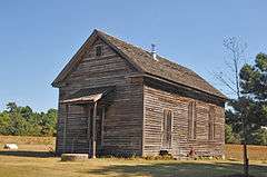
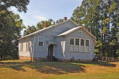
Bostick School |
|
000000002005-04-20-0000April 20, 2005
(#05000327) |
604 Clayton Carriker Rd.
35°07′34″N 79°46′22″W / 35.126111°N 79.772778°W / 35.126111; -79.772778 (Bostick School) |
Ellerbe |
|
| 3 |
Covington Plantation House |
Upload image |
000000001980-05-28-0000May 28, 1980
(#80002897) |
SW of Rockingham
34°53′49″N 79°48′13″W / 34.897072°N 79.803486°W / 34.897072; -79.803486 (Covington Plantation House) |
Rockingham |
|
| 4 |
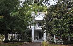
Alfred Dockery House |
|
000000001986-11-20-0000November 20, 1986
(#86003350) |
E side SR 1005, 0.1 mile S of jct. with SR 1143
35°00′38″N 79°48′48″W / 35.010556°N 79.813333°W / 35.010556; -79.813333 (Alfred Dockery House) |
Rockingham |
|
| 5 |
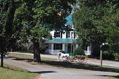
Ellerbe Springs Hotel |
|
000000001980-06-04-0000June 4, 1980
(#80002896) |
N of Ellerbe
35°05′30″N 79°45′48″W / 35.091667°N 79.763197°W / 35.091667; -79.763197 (Ellerbe Springs Hotel) |
Ellerbe |
|
| 6 |
Hannah Pickett Mill No. 1 |
Upload image |
000000001983-09-22-0000September 22, 1983
(#83001906) |
300 King Edward St.
34°55′02″N 79°45′40″W / 34.917222°N 79.761111°W / 34.917222; -79.761111 (Hannah Pickett Mill No. 1) |
Rockingham |
|
| 7 |
Liberty Hill School |
|
000000002008-01-17-0000January 17, 2008
(#07001409) |
234 Covington Comm. Rd.
35°08′15″N 79°52′00″W / 35.1375°N 79.866667°W / 35.1375; -79.866667 (Liberty Hill School) |
Ellerbe |
|
| 8 |
John Phillips Little House |
Upload image |
000000001984-12-20-0000December 20, 1984
(#84000590) |
Off NC 73
35°09′11″N 79°55′12″W / 35.153056°N 79.92°W / 35.153056; -79.92 (John Phillips Little House) |
Little's Mill |
|
| 9 |
Main Street Commercial Historic District |
|
000000001992-03-19-0000March 19, 1992
(#92000169) |
2-105 Main St.
34°53′03″N 79°41′59″W / 34.884167°N 79.699722°W / 34.884167; -79.699722 (Main Street Commercial Historic District) |
Hamlet |
|
| 10 |
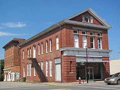
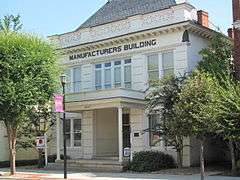
Manufacturers Building |
|
000000001979-05-29-0000May 29, 1979
(#79003348) |
220 E. Washington St.
34°56′21″N 79°46′22″W / 34.939303°N 79.772908°W / 34.939303; -79.772908 (Manufacturers Building) |
Rockingham |
|
| 11 |
Powell-Brookshire-Parker Farm |
Upload image |
000000002008-01-16-0000January 16, 2008
(#07001410) |
1881 E. NC 73
35°08′07″N 79°53′17″W / 35.135147°N 79.888014°W / 35.135147; -79.888014 (Powell-Brookshire-Parker Farm) |
Ellerbe |
|
| 12 |
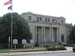
Richmond County Courthouse |
|
000000001979-05-10-0000May 10, 1979
(#79001747) |
Franklin St. between Hancock and Lee Sts.
34°56′15″N 79°46′26″W / 34.9375°N 79.773889°W / 34.9375; -79.773889 (Richmond County Courthouse) |
Rockingham |
|
| 13 |
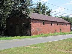
Roberdel Mill No. 1 Company Store |
|
000000001983-09-22-0000September 22, 1983
(#83001907) |
1106 Roberdel Rd.
34°58′18″N 79°44′40″W / 34.971667°N 79.744444°W / 34.971667; -79.744444 (Roberdel Mill No. 1 Company Store) |
Rockingham |
|
| 14 |
Rockingham Historic District |
|
000000001983-11-21-0000November 21, 1983
(#83003981) |
Roughly bounded by LeGrand and Brookwood Aves., Leak and Ann Sts.
34°56′29″N 79°45′47″W / 34.941389°N 79.763056°W / 34.941389; -79.763056 (Rockingham Historic District) |
Rockingham |
|
| 15 |
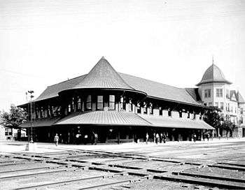
Seaboard Air Line Passenger Depot |
|
000000001971-11-19-0000November 19, 1971
(#71000617) |
2 Main St.
34°53′01″N 79°41′58″W / 34.883611°N 79.699444°W / 34.883611; -79.699444 (Seaboard Air Line Passenger Depot) |
Hamlet |
|
| 16 |
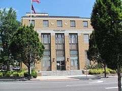
U. S. Post Office and Federal Building |
|
000000001983-09-22-0000September 22, 1983
(#83001908) |
125 S. Hancock St.
34°56′18″N 79°46′24″W / 34.938467°N 79.773258°W / 34.938467; -79.773258 (U. S. Post Office and Federal Building) |
Rockingham |
|
| 17 |
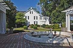
H. C. Watson House |
|
000000001983-09-22-0000September 22, 1983
(#83001909) |
526 Caroline St.
34°55′50″N 79°46′39″W / 34.930494°N 79.777617°W / 34.930494; -79.777617 (H. C. Watson House) |
Rockingham |
|
| [3] |
Name on the Register |
Image |
Date listed | Date removed |
Location |
City or town |
Summary |
|---|
| 1 |
Great Falls Mill |
|
000000001971-01-01-00001971
(#71001069) | 000000001973-01-01-00001973 |
W. Washington and Broad Aves.
|
Rockingham |
Destroyed by fire in 1972. Facade still standing. |
See also
References
- ↑ The latitude and longitude information provided in this table was derived originally from the National Register Information System, which has been found to be fairly accurate for about 99% of listings. For about 1% of NRIS original coordinates, experience has shown that one or both coordinates are typos or otherwise extremely far off; some corrections may have been made. A more subtle problem causes many locations to be off by up to 150 yards, depending on location in the country: most NRIS coordinates were derived from tracing out latitude and longitudes off of USGS topographical quadrant maps created under the North American Datum of 1927, which differs from the current, highly accurate WGS84 GPS system used by most on-line maps. Chicago is about right, but NRIS longitudes in Washington are higher by about 4.5 seconds, and are lower by about 2.0 seconds in Maine. Latitudes differ by about 1.0 second in Florida. Some locations in this table may have been corrected to current GPS standards.
- ↑ "National Register of Historic Places: Weekly List Actions". National Park Service, United States Department of the Interior. Retrieved on December 2, 2016.
- 1 2 Numbers represent an ordering by significant words. Various colorings, defined here, differentiate National Historic Landmarks and historic districts from other NRHP buildings, structures, sites or objects.
- ↑ The eight-digit number below each date is the number assigned to each location in the National Register Information System database, which can be viewed by clicking the number.
|
|---|
|
| Topics | | |
|---|
|
Lists
by county | |
|---|
|
| Other lists | |
|---|
|
|---|
|
| Topics | |
|---|
|
| Lists by states | |
|---|
|
| Lists by insular areas | |
|---|
|
| Lists by associated states | |
|---|
|
| Other areas | |
|---|
|
-
 Portal Portal
-
 WikiProject WikiProject
|

.png)

