| [3] |
Name on the Register[4] |
Image |
Date listed[5] |
Location |
City or town |
Description |
|---|
| 1 |
W. H. Applewhite House |
Upload image |
000000001986-02-13-0000February 13, 1986
(#86000696) |
Off NC 58
35°37′25″N 77°49′18″W / 35.623611°N 77.821667°W / 35.623611; -77.821667 (W. H. Applewhite House) |
Stantonsburg |
|
| 2 |
Manalcus Aycock House |
Upload image |
000000001986-02-13-0000February 13, 1986
(#86000765) |
Center St.
35°38′05″N 77°56′02″W / 35.634722°N 77.933889°W / 35.634722; -77.933889 (Manalcus Aycock House) |
Black Creek |
|
| 3 |
Gen. Joshua Barnes House |
Upload image |
000000001986-02-13-0000February 13, 1986
(#86000764) |
W side of SR 1326 at SR 1327
35°45′44″N 77°54′09″W / 35.762222°N 77.9025°W / 35.762222; -77.9025 (Gen. Joshua Barnes House) |
Wilson |
|
| 4 |
Black Creek Rural Historic District |
Upload image |
000000001986-10-14-0000October 14, 1986
(#86001659) |
Along NC 1628
35°37′36″N 77°53′22″W / 35.626667°N 77.889444°W / 35.626667; -77.889444 (Black Creek Rural Historic District) |
Black Creek |
|
| 5 |
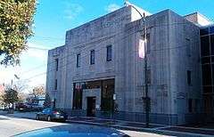
Branch Banking |
|
000000001978-08-11-0000August 11, 1978
(#78001986) |
124 E. Nash St.[6]
35°43′30″N 77°54′38″W / 35.725018°N 77.910522°W / 35.725018; -77.910522 (Branch Banking) |
Wilson |
|
| 6 |
Broad-Kenan Streets Historic District |
Upload image |
000000001988-10-27-0000October 27, 1988
(#88002084) |
Roughly bounded by Pine, Broad, Hines and Cone
35°43′44″N 77°55′04″W / 35.728889°N 77.917778°W / 35.728889; -77.917778 (Broad-Kenan Streets Historic District) |
Wilson |
|
| 7 |
Bullock-Dew House |
Upload image |
000000001986-02-13-0000February 13, 1986
(#86000759) |
NC 581
35°44′22″N 78°06′43″W / 35.739444°N 78.111944°W / 35.739444; -78.111944 (Bullock-Dew House) |
Sims |
|
| 8 |
Cherry Hotel |
|
000000001982-08-26-0000August 26, 1982
(#82003531) |
333 E. Nash St.
35°43′24″N 77°54′30″W / 35.723418°N 77.908412°W / 35.723418; -77.908412 (Cherry Hotel) |
Wilson |
|
| 9 |
Davis-Whitehead-Harriss House |
|
000000001982-06-14-0000June 14, 1982
(#82003532) |
600 W. Nash St.
35°43′57″N 77°54′57″W / 35.732423°N 77.915887°W / 35.732423; -77.915887 (Davis-Whitehead-Harriss House) |
Wilson |
|
| 10 |
East Wilson Historic District |
Upload image |
000000001988-04-11-0000April 11, 1988
(#88000371) |
Roughly bounded by E. Gold and Academy Sts., Ward Blvd., Woodard Street Ave. and Elvie St., and Railroad and Pender Sts.
35°43′10″N 77°54′10″W / 35.719444°N 77.902778°W / 35.719444; -77.902778 (East Wilson Historic District) |
Wilson |
|
| 11 |
Edmondson-Woodward House |
Upload image |
000000001986-02-13-0000February 13, 1986
(#86000767) |
NC 58 and SR 1542
35°39′08″N 77°49′57″W / 35.652222°N 77.8325°W / 35.652222; -77.8325 (Edmondson-Woodward House) |
Stantonsburg |
|
| 12 |
Elm City Municipal Historic District |
Upload image |
000000001986-02-13-0000February 13, 1986
(#86000770) |
Roughly bounded by North, Pender and Branch, Wilson, and Anderson Sts.
35°48′28″N 77°51′45″W / 35.807778°N 77.8625°W / 35.807778; -77.8625 (Elm City Municipal Historic District) |
Elm City |
|
| 13 |
W. H. Langley House |
Upload image |
000000001986-02-13-0000February 13, 1986
(#86000763) |
N side of SR 1003
35°48′31″N 77°52′45″W / 35.808611°N 77.879167°W / 35.808611; -77.879167 (W. H. Langley House) |
Elm City |
|
| 14 |
Lucama Municipal Historic District |
Upload image |
000000001986-02-13-0000February 13, 1986
(#86000772) |
Roughly bounded by US 301 and Railroad St., Main St., Black Creek Rd., and Goldsboro St.
35°38′35″N 78°00′38″W / 35.643056°N 78.010556°W / 35.643056; -78.010556 (Lucama Municipal Historic District) |
Lucama |
|
| 15 |
Dr. H. D. Lucas House |
Upload image |
000000001986-02-13-0000February 13, 1986
(#86000771) |
Center St.
35°38′12″N 77°56′04″W / 35.636667°N 77.934444°W / 35.636667; -77.934444 (Dr. H. D. Lucas House) |
Black Creek |
Demolished[7]
|
| 16 |
Old Wilson Historic District |
Upload image |
000000001984-12-20-0000December 20, 1984
(#84000736) |
Roughly bounded by Nash, N. Cone, Gold and Railroad Sts. and Maplewood Cemetery
35°43′51″N 77°54′38″W / 35.730833°N 77.910556°W / 35.730833; -77.910556 (Old Wilson Historic District) |
Wilson |
|
| 17 |
Joseph John Pender House |
Upload image |
000000001986-02-13-0000February 13, 1986
(#86000766) |
SR 1418 and SR 1002
35°46′17″N 77°46′28″W / 35.771389°N 77.774444°W / 35.771389; -77.774444 (Joseph John Pender House) |
Wilson |
|
| 18 |
Moses Rountree House |
Upload image |
000000001982-04-26-0000April 26, 1982
(#82003533) |
107 N. Rountree St.
35°44′02″N 77°54′55″W / 35.733889°N 77.915278°W / 35.733889; -77.915278 (Moses Rountree House) |
Wilson |
|
| 19 |
Maj. James Scarborough House |
Upload image |
000000001982-06-14-0000June 14, 1982
(#82003530) |
NC 222
35°39′46″N 77°46′03″W / 35.662778°N 77.7675°W / 35.662778; -77.7675 (Maj. James Scarborough House) |
Saratoga |
|
| 20 |
Alfred and Martha Jane Thompson House and Williams Barn |
Upload image |
000000002002-02-14-0000February 14, 2002
(#02000007) |
NC 1314, 0.4 miles W of NC 58
35°48′36″N 77°57′18″W / 35.81°N 77.955°W / 35.81; -77.955 (Alfred and Martha Jane Thompson House and Williams Barn) |
New Hope |
|
| 21 |
Upper Town Creek Rural Historic District |
Upload image |
000000001986-08-29-0000August 29, 1986
(#86001656) |
Roughly bounded by NC 1003, NC 1411, NC 1414, and Town Creek
35°47′57″N 77°45′25″W / 35.799167°N 77.756944°W / 35.799167; -77.756944 (Upper Town Creek Rural Historic District) |
Wilson |
|
| 22 |
Ward-Applewhite-Thompson House |
Upload image |
000000001986-02-13-0000February 13, 1986
(#86000695) |
S side of SR 1539
35°36′16″N 77°47′47″W / 35.604444°N 77.796389°W / 35.604444; -77.796389 (Ward-Applewhite-Thompson House) |
Stantonsburg |
|
| 23 |
Webb-Barron-Wells House |
Upload image |
000000001986-02-13-0000February 13, 1986
(#86000769) |
E side SR 1512
35°45′37″N 77°44′08″W / 35.760278°N 77.735556°W / 35.760278; -77.735556 (Webb-Barron-Wells House) |
Elm City |
|
| 24 |
West Nash Street Historic District |
Upload image |
000000001984-12-20-0000December 20, 1984
(#84001033) |
West Nash St.
35°44′18″N 77°55′14″W / 35.738333°N 77.920556°W / 35.738333; -77.920556 (West Nash Street Historic District) |
Wilson |
|
| 25 |
Olzie Whitehead Williams House |
Upload image |
000000001983-12-19-0000December 19, 1983
(#83004004) |
SR 1332
35°47′22″N 77°55′08″W / 35.789444°N 77.918889°W / 35.789444; -77.918889 (Olzie Whitehead Williams House) |
Wilson |
|
| 26 |
Wilson Central Business-Tobacco Warehouse Historic District |
|
000000001984-12-20-0000December 20, 1984
(#84003876) |
Roughly bounded by Pender, Green, Pine, S. Jackson, and Hines Sts.
35°43′26″N 77°54′41″W / 35.723936°N 77.911389°W / 35.723936; -77.911389 (Wilson Central Business-Tobacco Warehouse Historic District) |
Wilson |
|
| 27 |
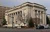
Wilson County Courthouse |
|
000000001979-05-10-0000May 10, 1979
(#79001765) |
Nash at Goldsboro St.
35°43′32″N 77°54′37″W / 35.725474°N 77.910279°W / 35.725474; -77.910279 (Wilson County Courthouse) |
Wilson |
|
| 28 |
Woodard Family Rural Historic District |
Upload image |
000000001986-08-29-0000August 29, 1986
(#86001657) |
Along US 264
35°41′30″N 77°50′18″W / 35.691667°N 77.838333°W / 35.691667; -77.838333 (Woodard Family Rural Historic District) |
Wilson |
|

_from_ENE_1.JPG)
_from_W_2.JPG)
_from_SW_1.JPG)