| [3] |
Name on the Register[4] |
Image |
Date listed[5] |
Location |
City or town |
Description |
|---|
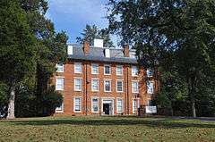
| 1 |
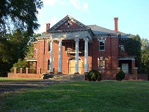
Barber-Scotia College |
|
000000001985-02-28-0000February 28, 1985
(#85000378) |
145 Cabarrus Ave. West
35°24′23″N 80°35′09″W / 35.406389°N 80.585833°W / 35.406389; -80.585833 (Barber-Scotia College) |
Concord |
|
| 2 |
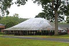
Bethel Church Arbor |
|
000000001997-05-23-0000May 23, 1997
(#97000472) |
Jct of SR 1123 and SR 1121
35°14′27″N 80°32′12″W / 35.240833°N 80.536667°W / 35.240833; -80.536667 (Bethel Church Arbor) |
Midland |
|
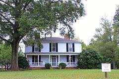
| 3 |
Boger-Hartsell Farm |
Upload image |
000000001998-07-23-0000July 23, 1998
(#98000890) |
Jct. of US 601 and SR 1148
35°18′53″N 80°31′00″W / 35.314722°N 80.516667°W / 35.314722; -80.516667 (Boger-Hartsell Farm) |
Concord |
|
| 4 |
Bost Mill Historic District |
Upload image |
000000001986-01-13-0000January 13, 1986
(#86000076) |
N and S sides of NC 200 off US 601
35°19′32″N 80°30′08″W / 35.325556°N 80.502222°W / 35.325556; -80.502222 (Bost Mill Historic District) |
Georgeville |
|
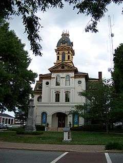
| 5 |
Cabarrus County Courthouse |
|
000000001974-06-05-0000June 5, 1974
(#74001328) |
Union St., S.
35°24′37″N 80°34′52″W / 35.410278°N 80.581111°W / 35.410278; -80.581111 (Cabarrus County Courthouse) |
Concord |
|
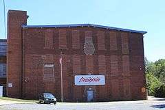
| 6 |
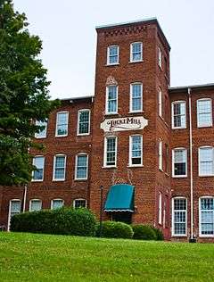
Coleman-Franklin-Cannon Mill |
|
000000002015-04-16-0000April 16, 2015
(#15000161) |
625 Main St., SW.
35°23′14″N 80°35′24″W / 35.3873°N 80.5899°W / 35.3873; -80.5899 (Coleman-Franklin-Cannon Mill) |
Concord |
|
| 7 |
Dr. Charles Favoni-Harris and William Shakespeare House |
Upload image |
000000001986-03-05-0000March 5, 1986
(#86000413) |
SR 1445
35°23′24″N 80°43′13″W / 35.39°N 80.720278°W / 35.39; -80.720278 (Dr. Charles Favoni-Harris and William Shakespeare House) |
Poplar Tent |
|
| 8 |
First Congregational Church |
|
000000001986-01-09-0000January 9, 1986
(#86000030) |
Corner of Wade and C Sts.
35°23′57″N 80°25′40″W / 35.399167°N 80.427778°W / 35.399167; -80.427778 (First Congregational Church) |
Mount Pleasant |
|
| 9 |
John Bunyan Green Farm |
Upload image |
000000001988-06-02-0000June 2, 1988
(#88000651) |
SR 1114 .5 miles E of SR 1178
35°12′56″N 80°29′23″W / 35.215556°N 80.489722°W / 35.215556; -80.489722 (John Bunyan Green Farm) |
Midland |
|
| 10 |
Daniel Isenhour House and Farm |
Upload image |
000000002000-04-21-0000April 21, 2000
(#00000392) |
11970 Mt. Olive Rd.
35°29′51″N 80°22′50″W / 35.4975°N 80.380556°W / 35.4975; -80.380556 (Daniel Isenhour House and Farm) |
Gold Hill |
|
| 11 |
Lentz Hotel |
|
000000001982-06-14-0000June 14, 1982
(#82003438) |
College St.
35°24′10″N 80°26′14″W / 35.402778°N 80.437222°W / 35.402778; -80.437222 (Lentz Hotel) |
Mount Pleasant |
|
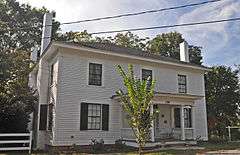
| 12 |
McCurdy Log House |
Upload image |
000000001974-01-21-0000January 21, 1974
(#74001329) |
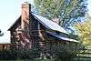
S of Concord off U.S. 601
35°19′03″N 80°32′32″W / 35.3175°N 80.542222°W / 35.3175; -80.542222 (McCurdy Log House) |
Concord |
|
| 13 |
Meek House |
Upload image |
000000002001-09-24-0000September 24, 2001
(#01001026) |
NC 1624, 0.3 miles NE of jct. with SR 1622
35°27′40″N 80°40′14″W / 35.461111°N 80.670556°W / 35.461111; -80.670556 (Meek House) |
Kannapolis |
|
| 14 |
Mill Hill |
Upload image |
000000001974-09-10-0000September 10, 1974
(#74001330) |
W of Kannapolis on SR 1616
35°28′36″N 80°41′59″W / 35.476667°N 80.699722°W / 35.476667; -80.699722 (Mill Hill) |
Concord |
|
| 15 |
Robert Harvey Morrison Farm and Pioneer Mills Gold Mine |
|
000000001990-12-31-0000December 31, 1990
(#90001952) |
730 Morrison Rd.
35°15′43″N 80°35′13″W / 35.261944°N 80.586944°W / 35.261944; -80.586944 (Robert Harvey Morrison Farm and Pioneer Mills Gold Mine) |
Midland |
|
| 16 |
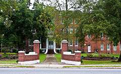
Mount Pleasant Collegiate Institute Historic District |
|
000000001979-11-15-0000November 15, 1979
(#79001686) |
Jct. of NC 49 and NC 73
35°24′08″N 80°26′12″W / 35.402222°N 80.436667°W / 35.402222; -80.436667 (Mount Pleasant Collegiate Institute Historic District) |
Mount Pleasant |
|
| 17 |
Mount Pleasant Historic District |
|
000000001986-05-12-0000May 12, 1986
(#86001050) |
Roughly W. and E. Franklin between N. Halifax and C and N and N. and S. Main Sts. between Boston and Broad Sts.
35°24′03″N 80°26′06″W / 35.400833°N 80.435°W / 35.400833; -80.435 (Mount Pleasant Historic District) |
Mount Pleasant |
|
| 18 |
North Union Street Historic District |
Upload image |
000000001986-04-15-0000April 15, 1986
(#86000789) |
Roughly bounded by Peachtree Ave. NW, Church St. N, Cobran Ave. SW, and Georgia St. NW and Spring St. N
35°24′46″N 80°35′13″W / 35.412778°N 80.586944°W / 35.412778; -80.586944 (North Union Street Historic District) |
Concord |
|
| 19 |
Odell-Locke-Randolph Cotton Mill |
|
000000001983-03-28-0000March 28, 1983
(#83001838) |
Buffalo, Church, Peachtree, and Locust Sts.
35°25′06″N 80°35′26″W / 35.418333°N 80.590556°W / 35.418333; -80.590556 (Odell-Locke-Randolph Cotton Mill) |
Concord |
|
| 20 |
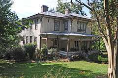
Harvey Jeremiah Peeler House |
|
000000002007-08-16-0000August 16, 2007
(#07000818) |
101 S. Ridge Ave.
35°29′50″N 80°37′24″W / 35.497222°N 80.623333°W / 35.497222; -80.623333 (Harvey Jeremiah Peeler House) |
Kannapolis |
|
| 21 |
Rev. John E. Pressley House |
Upload image |
000000001986-01-06-0000January 6, 1986
(#86000029) |
N side of SR 1613 0.3 miles E of SR 1612
35°30′18″N 80°45′40″W / 35.505°N 80.761111°W / 35.505; -80.761111 (Rev. John E. Pressley House) |
Bethpage |
|
| 22 |
Reed Gold Mine |
|
000000001966-10-15-0000October 15, 1966
(#66000587) |
11 miles SE of Concord
35°16′52″N 80°27′36″W / 35.281111°N 80.46°W / 35.281111; -80.46 (Reed Gold Mine) |
Concord |
|
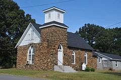
| 23 |
Rocky River Presbyterian Church |
|
000000001986-03-06-0000March 6, 1986
(#86000419) |
Jct. of SR 1139 and SR 1158
35°18′09″N 80°35′58″W / 35.3025°N 80.599444°W / 35.3025; -80.599444 (Rocky River Presbyterian Church) |
Rocky River |
|
| 24 |
South Union Street Courthouse and Commercial Historic District |
Upload image |
000000001997-09-30-0000September 30, 1997
(#97001196) |
Along Union St., bounded by Corban and Cabarrus Aves.
35°24′34″N 80°34′49″W / 35.409444°N 80.580278°W / 35.409444; -80.580278 (South Union Street Courthouse and Commercial Historic District) |
Concord |
|
| 25 |
South Union Street Historic District |
Upload image |
000000001986-04-10-0000April 10, 1986
(#86000736) |
Roughly bounded by Corban Ave. SW, S. Union St., Blume Ave. SE, and Spring St. SW
35°24′13″N 80°34′30″W / 35.403611°N 80.575°W / 35.403611; -80.575 (South Union Street Historic District) |
Concord |
|
| 26 |
Spears House |
|
000000001989-08-07-0000August 7, 1989
(#89001046) |
1615 Morrison Rd.
35°15′14″N 80°36′10″W / 35.253889°N 80.602778°W / 35.253889; -80.602778 (Spears House) |
Concord |
|
| 27 |
Stonewall Jackson Training School Historic District |
|
000000001984-03-15-0000March 15, 1984
(#84001966) |
SR 1157
35°21′51″N 80°35′54″W / 35.364167°N 80.598333°W / 35.364167; -80.598333 (Stonewall Jackson Training School Historic District) |
Concord |
|
| 28 |
Union Street North-Cabarrus Avenue Commercial Historic District |
Upload image |
000000002003-12-10-0000December 10, 2003
(#03001272) |
Roughly Union St. N, Cabarrus Ave. E, Cabarrus Ave. W, and Church St. S
35°24′38″N 80°34′53″W / 35.410556°N 80.581389°W / 35.410556; -80.581389 (Union Street North-Cabarrus Avenue Commercial Historic District) |
Concord |
|
_side_view.jpg)
_Church.jpg)