| [3] |
Name on the Register[4] |
Image |
Date listed[5] |
Location |
City or town |
Description |
|---|
| 1 |
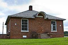
Abrams Plains |
Upload image |
000000001979-11-29-0000November 29, 1979
(#79001711) |
NW of Stovall
36°28′58″N 78°30′51″W / 36.482778°N 78.514167°W / 36.482778; -78.514167 (Abrams Plains) |
Stovall |
|
| 2 |
Adoniram Masonic Lodge |
Upload image |
000000001988-08-31-0000August 31, 1988
(#88001253) |
Jct. of NC 1410 and NC 1300
36°28′46″N 78°39′58″W / 36.479444°N 78.666111°W / 36.479444; -78.666111 (Adoniram Masonic Lodge) |
Cornwall |
|
| 3 |
Allen-Mangum House |
Upload image |
000000001988-04-28-0000April 28, 1988
(#88000410) |
NC 1700
36°06′20″N 78°37′02″W / 36.105556°N 78.617222°W / 36.105556; -78.617222 (Allen-Mangum House) |
Grissom |
|
| 4 |
Rufus Amis House and Mill |
Upload image |
000000001988-04-28-0000April 28, 1988
(#88000416) |
Address Restricted
|
Virgilina |
|
| 5 |
James Blackwell House |
Upload image |
000000001988-04-28-0000April 28, 1988
(#88000407) |
NC 1411
36°27′39″N 78°41′29″W / 36.460833°N 78.691389°W / 36.460833; -78.691389 (James Blackwell House) |
Cornwall |
|
| 6 |
Bobbitt-Rogers House and Tobacco Manufactory District |
Upload image |
000000001988-08-31-0000August 31, 1988
(#88001262) |
Address Restricted
|
Wilton |
|
| 7 |
Brassfield Baptist Church |
Upload image |
000000001988-08-31-0000August 31, 1988
(#88001267) |
NC 96 and NC 1700
36°06′54″N 78°34′30″W / 36.115°N 78.575°W / 36.115; -78.575 (Brassfield Baptist Church) |
Wilton |
|
| 8 |
Brookland |
Upload image |
000000001988-04-28-0000April 28, 1988
(#88000412) |
NC 1443
36°31′03″N 78°34′32″W / 36.5175°N 78.575556°W / 36.5175; -78.575556 (Brookland) |
Grassy Creek |
|
| 9 |
Central Orphanage |
|
000000001988-08-31-0000August 31, 1988
(#88001257) |
Antioch Dr. and Raleigh Rd.
36°17′35″N 78°34′21″W / 36.293056°N 78.5725°W / 36.293056; -78.5725 (Central Orphanage) |
Oxford |
|
| 10 |
Edgewood |
Upload image |
000000001988-04-28-0000April 28, 1988
(#88000421) |
NC 1437
36°30′27″N 78°38′08″W / 36.5075°N 78.635556°W / 36.5075; -78.635556 (Edgewood) |
Grassy Creek |
|
| 11 |
William Ellixson House |
Upload image |
000000001988-04-28-0000April 28, 1988
(#88000404) |
Address Restricted
|
Wilbourns |
|
| 12 |
Elmwood |
Upload image |
000000001988-04-28-0000April 28, 1988
(#88000406) |
Address Restricted
|
Lewis |
|
| 13 |
First National Bank Building |
Upload image |
000000001988-08-31-0000August 31, 1988
(#88001254) |
302 Main St.
36°07′08″N 78°41′12″W / 36.118889°N 78.686667°W / 36.118889; -78.686667 (First National Bank Building) |
Creedmoor |
|
| 14 |
James W. Freeman House |
Upload image |
000000001988-04-28-0000April 28, 1988
(#88000411) |
NC 1623
36°10′18″N 78°33′19″W / 36.171667°N 78.555278°W / 36.171667; -78.555278 (James W. Freeman House) |
Wilton |
|
| 15 |
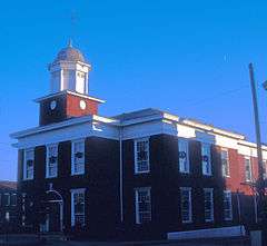
Granville County Courthouse |
|
000000001979-05-10-0000May 10, 1979
(#79001710) |
Main and Williamsboro Sts.
36°18′42″N 78°35′15″W / 36.311667°N 78.5875°W / 36.311667; -78.5875 (Granville County Courthouse) |
Oxford |
|
| 16 |
Harris-Currin House |
Upload image |
000000001988-08-31-0000August 31, 1988
(#88001258) |
Address Restricted
|
Wilton |
|
| 17 |
Maurice Hart House |
Upload image |
000000001988-04-28-0000April 28, 1988
(#88000420) |
NC 1430
36°26′57″N 78°34′36″W / 36.449167°N 78.576667°W / 36.449167; -78.576667 (Maurice Hart House) |
Stovall |
|
| 18 |
Hill Airy |
Upload image |
000000001974-10-29-0000October 29, 1974
(#74001349) |
S of Stovall
36°24′35″N 78°33′54″W / 36.409722°N 78.565°W / 36.409722; -78.565 (Hill Airy) |
Stovall |
|
| 19 |
Joseph P. Hunt Farm |
Upload image |
000000001988-08-31-0000August 31, 1988
(#88001265) |
NC 1514
36°23′07″N 78°32′48″W / 36.385278°N 78.546667°W / 36.385278; -78.546667 (Joseph P. Hunt Farm) |
Dexter |
|
| 20 |
John P. Lawrence Plantation |
Upload image |
000000001988-08-31-0000August 31, 1988
(#88001264) |
NC 1700
36°06′56″N 78°35′31″W / 36.115556°N 78.591944°W / 36.115556; -78.591944 (John P. Lawrence Plantation) |
Grissom |
|
| 21 |
Joseph B. Littlejohn House |
Upload image |
000000001988-08-31-0000August 31, 1988
(#88001268) |
219 Devin St.
36°18′43″N 78°34′51″W / 36.311944°N 78.580833°W / 36.311944; -78.580833 (Joseph B. Littlejohn House) |
Oxford |
|
| 22 |
Locust Lawn |
Upload image |
000000001988-04-28-0000April 28, 1988
(#88000422) |
Address Restricted
|
Oxford |
|
| 23 |
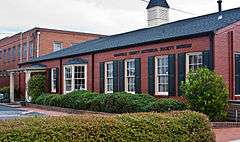
Mount Energy Historic District |
Upload image |
000000001988-08-31-0000August 31, 1988
(#88001266) |
NC 1636 and NC 56
36°07′31″N 78°38′32″W / 36.125278°N 78.642222°W / 36.125278; -78.642222 (Mount Energy Historic District) |
Mount Energy |
|
| 24 |
Oak Lawn |
Upload image |
000000001988-04-28-0000April 28, 1988
(#88000408) |
Address Restricted
|
Huntsboro |
|
| 25 |
Oliver-Morton Farm |
Upload image |
000000001988-08-31-0000August 31, 1988
(#88001269) |
NC 1417
36°25′38″N 78°40′51″W / 36.427222°N 78.680833°W / 36.427222; -78.680833 (Oliver-Morton Farm) |
Oak Hill |
|
| 26 |
Oxford Historic District |
|
000000001988-04-28-0000April 28, 1988
(#88000403) |
Roughly bounded by College, New College and Gilliam and Raleigh, Front, Broad and Goshen and Hayes Sts.
36°18′41″N 78°35′25″W / 36.311389°N 78.590278°W / 36.311389; -78.590278 (Oxford Historic District) |
Oxford |
|
| 27 |
Paschall-Daniel House |
Upload image |
000000001992-06-04-0000June 4, 1992
(#88001263) |
Address Restricted
|
Oxford |
|
| 28 |
John Mask Peace House |
Upload image |
000000002003-04-22-0000April 22, 2003
(#03000301) |
NC 1613, approx. 0.5 miles SE of jct. with NC 1615 at Peace's Chapel
36°13′15″N 78°30′41″W / 36.220833°N 78.511389°W / 36.220833; -78.511389 (John Mask Peace House) |
Fairport |
|
| 29 |
John Peace Jr. House |
Upload image |
000000001988-04-28-0000April 28, 1988
(#88000405) |
NC 1627
36°09′08″N 78°31′09″W / 36.152222°N 78.519167°W / 36.152222; -78.519167 (John Peace Jr. House) |
Wilton |
|
| 30 |
Puckett Family Farm |
Upload image |
000000001988-04-28-0000April 28, 1988
(#88000423) |
NC 1333
36°22′02″N 78°40′09″W / 36.367222°N 78.669167°W / 36.367222; -78.669167 (Puckett Family Farm) |
Satterwhite |
|
| 31 |
Red Hill |
Upload image |
000000001986-08-14-0000August 14, 1986
(#86001632) |
NC 1501
36°31′44″N 78°31′13″W / 36.528889°N 78.520278°W / 36.528889; -78.520278 (Red Hill) |
Bullock |
|
| 32 |
Rose Hill |
Upload image |
000000001988-04-28-0000April 28, 1988
(#88000415) |
NC 1442
36°31′20″N 78°36′35″W / 36.522222°N 78.609722°W / 36.522222; -78.609722 (Rose Hill) |
Grassy Creek |
|
| 33 |
John Henry Royster Farm |
Upload image |
000000001988-08-31-0000August 31, 1988
(#88001260) |
Address Restricted
|
Bullock |
|
| 34 |
Marcus Royster Plantation |
Upload image |
000000001988-04-28-0000April 28, 1988
(#88000409) |
NC 96
36°28′16″N 78°43′40″W / 36.471111°N 78.727778°W / 36.471111; -78.727778 (Marcus Royster Plantation) |
Wilbourns |
|
| 35 |
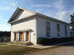
Salem Methodist Church |
|
000000001988-08-31-0000August 31, 1988
(#88001259) |
NC 1522
36°21′01″N 78°32′22″W / 36.350278°N 78.539444°W / 36.350278; -78.539444 (Salem Methodist Church) |
Huntsboro |
|
| 36 |
Elijah Sherman Farm |
Upload image |
000000001988-08-31-0000August 31, 1988
(#88001256) |
US 158
36°19′46″N 78°46′47″W / 36.329444°N 78.779722°W / 36.329444; -78.779722 (Elijah Sherman Farm) |
Berea |
|
| 37 |
William G. Smith House |
Upload image |
000000001988-04-28-0000April 28, 1988
(#88000417) |
NC 1527
36°32′22″N 78°31′03″W / 36.539444°N 78.5175°W / 36.539444; -78.5175 (William G. Smith House) |
Bullock |
|
| 38 |
John W. Stovall Farm |
Upload image |
000000001988-08-31-0000August 31, 1988
(#88001270) |
NC 1507
36°27′22″N 78°33′23″W / 36.456111°N 78.556389°W / 36.456111; -78.556389 (John W. Stovall Farm) |
Stovall |
|
| 39 |
Sycamore Valley |
Upload image |
000000001988-04-28-0000April 28, 1988
(#88000419) |
NC 1400
36°31′04″N 78°37′54″W / 36.517778°N 78.631667°W / 36.517778; -78.631667 (Sycamore Valley) |
Grassy Creek |
|
| 40 |
Archibald Taylor Plantation House |
Upload image |
000000002001-10-20-0000October 20, 2001
(#01001132) |
5632 Tabbs Creek Rd.
36°19′18″N 78°32′31″W / 36.321667°N 78.541944°W / 36.321667; -78.541944 (Archibald Taylor Plantation House) |
Oxford |
|
| 41 |
Col. Richard P. Taylor House |
Upload image |
000000001988-04-28-0000April 28, 1988
(#88000414) |
NC 1524
36°20′09″N 78°32′20″W / 36.335833°N 78.538889°W / 36.335833; -78.538889 (Col. Richard P. Taylor House) |
Huntsboro |
|
| 42 |
Thorndale |
|
000000001988-04-28-0000April 28, 1988
(#88000413) |
213 W. Thorndale Dr.
36°18′12″N 78°36′23″W / 36.303333°N 78.606389°W / 36.303333; -78.606389 (Thorndale) |
Oxford |
|
| 43 |
Eldon B. Tunstall Farm |
Upload image |
000000001988-08-31-0000August 31, 1988
(#88001255) |
NC 1500
36°31′55″N 78°31′55″W / 36.531944°N 78.531944°W / 36.531944; -78.531944 (Eldon B. Tunstall Farm) |
Bullock |
|
| 44 |
Lewis Wimbish Plantation |
Upload image |
000000001988-04-28-0000April 28, 1988
(#88000418) |
NC 1443
36°31′21″N 78°35′22″W / 36.5225°N 78.589444°W / 36.5225; -78.589444 (Lewis Wimbish Plantation) |
Grassy Creek |
|
| 45 |
Obediah Winston Farm |
Upload image |
000000001988-08-31-0000August 31, 1988
(#88001261) |
NC 1638
36°08′20″N 78°40′02″W / 36.138889°N 78.667222°W / 36.138889; -78.667222 (Obediah Winston Farm) |
Creedmoor |
|