Illahee, Washington
| Illahee | |
|---|---|
| Unincorporated community | |
 Illahee Location within the state of Washington | |
| Coordinates: 47°36′46″N 122°35′48″W / 47.61278°N 122.59667°WCoordinates: 47°36′46″N 122°35′48″W / 47.61278°N 122.59667°W | |
| Country | United States |
| State | Washington |
| County | Kitsap |
| Time zone | Pacific (PST) (UTC-8) |
| • Summer (DST) | PDT (UTC-7) |
| GNIS feature ID | 1512320 |
Illahee is an unincorporated community in Kitsap County, Washington, United States,[1] between Bremerton and Silverdale. It is home to Illahee State Park and other local parks. The word "Illahee" means earth or country in the Indian tradition.
Geography
Illahee's altitude is 36 feet (11 m).[1]
Port
The Port of Illahee community dock was built around 1916 to serve the Puget Sound Mosquito Fleet. In later years this port was used by the United States Navy to demagnetize ships.
Parks and recreation
75-acre (300,000 m2) Illahee State Park, located north of eastern Bremerton, is part of the Washington State Park System. The waterfront land for the park was acquired between 1934 and 1954. The park offers camping, hiking, a boat launch, and a dock.
The 460-acre (1.9 km2) Illahee Preserve and the 110-acre (0.45 km2) Rolling Hills golf course are both in Illahee as well. The area of the Illahee Preserve that is most easily accessible from NE Riddell Road is often used by juveniles and young adults as an area to inconspicuously smoke marijuana from pipes fashioned out of aluminum cans.
References
http://www.kitsapgov.com/dcd/community_plan/subareas/Illahee/subarea_finaled.htm
Municipalities and communities of Kitsap County, Washington, United States | ||
|---|---|---|
| Cities | 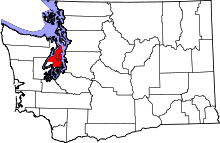 | |
| CDPs | ||
| Other unincorporated communities | ||
| Indian reservation | ||