| [3] |
Name on the Register |
Image |
Date listed[4] |
Location |
City or town |
Description |
|---|
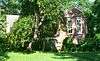
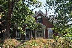
| 1 |
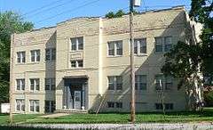
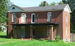
Andrews-Wing House |
|
000000001990-03-16-0000March 16, 1990
(#82005304) |
733 Main St.
38°58′17″N 92°44′33″W / 38.971389°N 92.7425°W / 38.971389; -92.7425 (Andrews-Wing House) |
Boonville |
|
| 2 |
Arrow Rock |
|
000000001966-10-15-0000October 15, 1966
(#66000422) |
Arrow Rock State Park
39°04′00″N 92°56′41″W / 39.066667°N 92.944722°W / 39.066667; -92.944722 (Arrow Rock) |
Arrow Rock |
|
| 3 |
William S. and Mary Beckett House |
Upload image |
000000001990-03-16-0000March 16, 1990
(#82005288) |
821 Third St.
38°58′08″N 92°44′43″W / 38.968889°N 92.745278°W / 38.968889; -92.745278 (William S. and Mary Beckett House) |
Boonville |
|
| 4 |
Blackwater Commercial Historic District |
Upload image |
000000002005-01-20-0000January 20, 2005
(#04001520) |
100 Blk. of Main St., except for 118,120 and 122 Main St.
38°58′57″N 92°59′26″W / 38.9825°N 92.990556°W / 38.9825; -92.990556 (Blackwater Commercial Historic District) |
Blackwater |
|
| 5 |
Blackwater Residential Historic District |
Upload image |
000000002009-09-05-0000September 5, 2009
(#09000597) |
Parts of the 300-400 block of Trigg Ave., 300 block of Scott Ave. and the 300 block of Main St.
38°58′49″N 92°59′28″W / 38.980317°N 92.990983°W / 38.980317; -92.990983 (Blackwater Residential Historic District) |
Blackwater |
|
| 6 |
Albert Gallatin Blakey House |
Upload image |
000000001990-03-16-0000March 16, 1990
(#82005289) |
226 W. Spring St.
38°58′24″N 92°45′10″W / 38.973333°N 92.752778°W / 38.973333; -92.752778 (Albert Gallatin Blakey House) |
Boonville |
|
| 7 |
Boller House |
Upload image |
000000001977-08-02-0000August 2, 1977
(#77000803) |
223 E. Spring St.
38°58′30″N 92°44′50″W / 38.975°N 92.747222°W / 38.975; -92.747222 (Boller House) |
Boonville |
Demolished.[5]
|
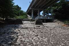
| 8 |
Cobblestone Street |
|
000000001990-03-16-0000March 16, 1990
(#82005293) |
100 Main St.
38°58′41″N 92°44′40″W / 38.978056°N 92.744444°W / 38.978056; -92.744444 (Cobblestone Street) |
Boonville |
|
| 9 |
John S. Dauwalter House |
|
000000001990-03-16-0000March 16, 1990
(#82005296) |
817 Seventh St.
38°58′14″N 92°44′22″W / 38.970457°N 92.739582°W / 38.970457; -92.739582 (John S. Dauwalter House) |
Boonville |
|
| 10 |
Dick-Kobel Homestead |
Upload image |
000000001982-09-09-0000September 9, 1982
(#82003133) |
W of Jamestown
38°44′48″N 92°35′33″W / 38.746667°N 92.5925°W / 38.746667; -92.5925 (Dick-Kobel Homestead) |
Jamestown |
|
| 11 |
Duke and Mary Diggs House |
|
000000001990-03-16-0000March 16, 1990
(#82005297) |
1217 Rural St.
38°58′48″N 92°44′00″W / 38.980046°N 92.733335°W / 38.980046; -92.733335 (Duke and Mary Diggs House) |
Boonville |
|
| 12 |
Fessler-Secongost House |
Upload image |
000000001990-03-16-0000March 16, 1990
(#82005335) |
119 W. Morgan St.
38°58′32″N 92°45′02″W / 38.975556°N 92.750556°W / 38.975556; -92.750556 (Fessler-Secongost House) |
Boonville |
|
| 13 |
Andrew Gantner House |
Upload image |
000000001990-03-16-0000March 16, 1990
(#82005303) |
1308 Sixth St.
38°57′52″N 92°44′18″W / 38.964444°N 92.738333°W / 38.964444; -92.738333 (Andrew Gantner House) |
Boonville |
|
| 14 |
Hamilton-Brown Shoe Company Building |
|
000000001990-03-16-0000March 16, 1990
(#82005305) |
301 1st Street[6]
38°58′29″N 92°45′01″W / 38.974780°N 92.750363°W / 38.974780; -92.750363 (Hamilton-Brown Shoe Company Building) |
Boonville |
|
| 15 |
Harley Park Archeological Site |
Upload image |
000000001970-10-15-0000October 15, 1970
(#70000329) |
Address Restricted
|
Boonville |
|
| 16 |
Historic District A |
Upload image |
000000001983-01-24-0000January 24, 1983
(#83000979) |
Vine and 2nd Sts.
38°58′15″N 92°44′48″W / 38.970833°N 92.746667°W / 38.970833; -92.746667 (Historic District A) |
Boonville |
|
| 17 |
Historic District B |
Upload image |
000000001983-01-24-0000January 24, 1983
(#83000980) |
4th and E. Spring Sts.
38°58′26″N 92°44′40″W / 38.973889°N 92.744444°W / 38.973889; -92.744444 (Historic District B) |
Boonville |
|
| 18 |
Historic District C |
Upload image |
000000001983-01-24-0000January 24, 1983
(#83000981) |
E. High and 4th Sts
38°58′33″N 92°44′48″W / 38.975833°N 92.746667°W / 38.975833; -92.746667 (Historic District C) |
Boonville |
|
| 19 |
Historic District D |
|
000000001983-01-24-0000January 24, 1983
(#83000982) |
High and Main Sts.
38°58′32″N 92°44′37″W / 38.975556°N 92.743611°W / 38.975556; -92.743611 (Historic District D) |
Boonville |
|
| 20 |
Historic District E |
Upload image |
000000001983-01-24-0000January 24, 1983
(#83000983) |
High, Spring and Morgan Sts.
38°58′38″N 92°44′25″W / 38.977222°N 92.740278°W / 38.977222; -92.740278 (Historic District E) |
Boonville |
|
| 21 |
Historic District F |
Upload image |
000000001983-01-24-0000January 24, 1983
(#83000984) |
Extends North and South along 6th and 7th Sts.
38°58′20″N 92°44′24″W / 38.972222°N 92.74°W / 38.972222; -92.74 (Historic District F) |
Boonville |
|
| 22 |
Historic District H |
Upload image |
000000001983-01-24-0000January 24, 1983
(#83000985) |
SE corner of E. Morgan St. and Reformatory Dr.
38°58′35″N 92°43′50″W / 38.976389°N 92.730556°W / 38.976389; -92.730556 (Historic District H) |
Boonville |
|
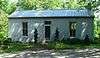
| 23 |
Imhoff Archeological Site |
Upload image |
000000001972-08-07-0000August 7, 1972
(#72000710) |
Address Restricted
|
Blackwater |
|
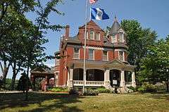
| 24 |
Juliet Trigg Johnson House |
|
000000001990-03-16-0000March 16, 1990
(#82005327) |
1304 Main St.
38°57′50″N 92°44′24″W / 38.963889°N 92.74°W / 38.963889; -92.74 (Juliet Trigg Johnson House) |
Boonville |
|
| 25 |
Wilbur T. and Rhoda Stephens Johnson House |
|
000000001990-03-16-0000March 16, 1990
(#82005322) |
821 Main
38°58′12″N 92°43′50″W / 38.97°N 92.730556°W / 38.97; -92.730556 (Wilbur T. and Rhoda Stephens Johnson House) |
Boonville |
|
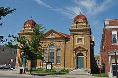
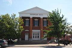
| 26 |
Lyric Theater |
|
000000001969-05-21-0000May 21, 1969
(#69000097) |
NE corner of Main and Vine Sts.
38°58′26″N 92°44′33″W / 38.973889°N 92.7425°W / 38.973889; -92.7425 (Lyric Theater) |
Boonville |
|
| 27 |
Meierhoffer House |
Upload image |
000000001990-03-16-0000March 16, 1990
(#82005317) |
120 E. High St.
38°58′34″N 92°45′01″W / 38.976111°N 92.750278°W / 38.976111; -92.750278 (Meierhoffer House) |
Boonville |
|
| 28 |
Meierhoffer Sand Company Office Building |
|
000000001990-03-16-0000March 16, 1990
(#82005318) |
201 Second St.
38°58′33″N 92°45′01″W / 38.975833°N 92.750278°W / 38.975833; -92.750278 (Meierhoffer Sand Company Office Building) |
Boonville |
Apparently no longer extant[7]
|
| 29 |
Mellor Village and Mounds Archeological District |
Upload image |
000000001969-05-21-0000May 21, 1969
(#69000098) |
Address Restricted
|
Lamine |
Boundaries increased on 000000001974-08-07-0000August 7, 1974
|
| 30 |
Missouri, Kansas and Texas Railroad Depot |
|
000000001990-03-16-0000March 16, 1990
(#82005312) |
320 First St.
38°58′30″N 92°44′57″W / 38.975°N 92.749167°W / 38.975; -92.749167 (Missouri, Kansas and Texas Railroad Depot) |
Boonville |
|
| 31 |
Morton-Myer House |
Upload image |
000000001990-03-16-0000March 16, 1990
(#82005316) |
1000 Eleventh St.
38°58′10″N 92°43′51″W / 38.969444°N 92.730833°W / 38.969444; -92.730833 (Morton-Myer House) |
Boonville |
|
| 32 |
Mount Nebo Baptist Church |
Upload image |
000000001986-05-23-0000May 23, 1986
(#86001111) |
MO 135/E
38°48′12″N 92°53′22″W / 38.803333°N 92.889444°W / 38.803333; -92.889444 (Mount Nebo Baptist Church) |
Pilot Grove |
|
| 33 |
Thomas Nelson House |
Upload image |
000000001990-03-16-0000March 16, 1990
(#82005302) |
700 Tenth St.
38°58′26″N 92°44′05″W / 38.973889°N 92.734722°W / 38.973889; -92.734722 (Thomas Nelson House) |
Boonville |
|
| 34 |
New Lebanon Cumberland Presbyterian Church and School |
Upload image |
000000001979-07-09-0000July 9, 1979
(#79001359) |
MO A
38°45′53″N 92°56′20″W / 38.764722°N 92.938889°W / 38.764722; -92.938889 (New Lebanon Cumberland Presbyterian Church and School) |
New Lebanon |
|
| 35 |
New Lebanon Historic District |
Upload image |
000000001998-06-11-0000June 11, 1998
(#98000597) |
Roughly, Area W and SE of jct of MO A and New Lebanon Loop
38°46′28″N 92°56′21″W / 38.774444°N 92.939167°W / 38.774444; -92.939167 (New Lebanon Historic District) |
New Lebanon |
|
| 36 |
Josephine Trigg Pigott House |
|
000000001990-03-16-0000March 16, 1990
(#82005328) |
1307 Sixth St.
38°57′52″N 92°44′21″W / 38.964463°N 92.739193°W / 38.964463; -92.739193 (Josephine Trigg Pigott House) |
Boonville |
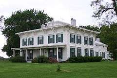
|
| 37 |
Pleasant Green |
Upload image |
000000001977-07-29-0000July 29, 1977
(#77000804) |
8 miles SW of Pilot Grove on U.S. 135
38°48′11″N 92°59′15″W / 38.803056°N 92.9875°W / 38.803056; -92.9875 (Pleasant Green) |
Pilot Grove |
|
| 38 |
Prairie View |
|
000000001982-09-20-0000September 20, 1982
(#82003134) |
E of Pleasant Green off MO 135
38°47′36″N 92°55′51″W / 38.793333°N 92.930833°W / 38.793333; -92.930833 (Prairie View) |
Pleasant Green |
|
| 39 |
Ravenswood |
|
000000001975-02-24-0000February 24, 1975
(#75001065) |
NW of Bunceton on MO 5
38°49′19″N 92°50′17″W / 38.821944°N 92.838056°W / 38.821944; -92.838056 (Ravenswood) |
Bunceton |
|
| 40 |
Roeschel-Toennes-Oswald Property |
|
000000001983-07-07-0000July 7, 1983
(#83000986) |
Santa Fe Trail at West End Drive
38°58′22″N 92°45′22″W / 38.972698°N 92.756092°W / 38.972698; -92.756092 (Roeschel-Toennes-Oswald Property) |
Boonville |
|
| 41 |
St. Matthew's Chapel A.M.E. Church |
|
000000001990-03-16-0000March 16, 1990
(#82005324) |
309 Spruce St.
38°58′14″N 92°44′41″W / 38.970437°N 92.744838°W / 38.970437; -92.744838 (St. Matthew's Chapel A.M.E. Church) |
Boonville |
|
| 42 |
Sumner Public School |
|
000000001990-03-16-0000March 16, 1990
(#82005331) |
321 Spruce St.
38°58′14″N 92°44′39″W / 38.970521°N 92.744291°W / 38.970521; -92.744291 (Sumner Public School) |
Boonville |
|
| 43 |
Wooldridge Archeological Site |
Upload image |
000000001970-12-02-0000December 2, 1970
(#70000330) |
Address Restricted
|
Wooldridge |
|
_from_NE_3.JPG)


_from_SE_1.JPG)