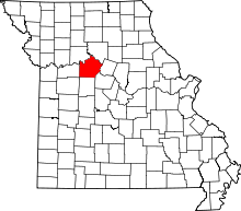
| [3] |
Name on the Register |
Image |
Date listed[4] |
Location |
City or town |
Description |
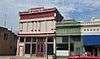
|---|
| 1 |
Arrow Rock Ferry Landing |
Upload image |
000000002013-05-01-0000May 1, 2013
(#08000664) |
Northern extension of 2nd St.[5]
39°04′27″N 92°56′37″W / 39.074167°N 92.943611°W / 39.074167; -92.943611 (Arrow Rock Ferry Landing) |
Arrow Rock |
|
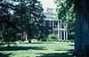
| 2 |
Arrow Rock |
|
000000001966-10-15-0000October 15, 1966
(#66000422) |
Arrow Rock State Park
39°04′00″N 92°56′41″W / 39.066667°N 92.944722°W / 39.066667; -92.944722 (Arrow Rock) |
Arrow Rock |
|
| 3 |
Arrow Rock State Historic Site Bridge |
Upload image |
000000001985-03-04-0000March 4, 1985
(#85000516) |
Southeast of Arrow Rock
39°04′06″N 92°56′39″W / 39.068333°N 92.944167°W / 39.068333; -92.944167 (Arrow Rock State Historic Site Bridge) |
Arrow Rock |
|
| 4 |
Arrow Rock State Historic Site Grave Shelter |
Upload image |
000000001985-02-27-0000February 27, 1985
(#85000534) |
Southeast of Arrow Rock
39°04′06″N 92°56′39″W / 39.068333°N 92.944167°W / 39.068333; -92.944167 (Arrow Rock State Historic Site Grave Shelter) |
Arrow Rock |
|
| 5 |
Arrow Rock State Historic Site Lookout Shelter |
Upload image |
000000001985-02-27-0000February 27, 1985
(#85000535) |
East of Arrow Rock
39°04′16″N 92°56′33″W / 39.071111°N 92.9425°W / 39.071111; -92.9425 (Arrow Rock State Historic Site Lookout Shelter) |
Arrow Rock |
|
| 6 |
Arrow Rock State Historic Site Open Shelter |
Upload image |
000000001985-02-28-0000February 28, 1985
(#85000536) |
Southeast of Arrow Rock
39°04′04″N 92°56′31″W / 39.067778°N 92.941944°W / 39.067778; -92.941944 (Arrow Rock State Historic Site Open Shelter) |
Arrow Rock |
|
| 7 |
Arrow Rock Tavern |
|
000000001972-02-23-0000February 23, 1972
(#72000729) |
Main St.
39°04′03″N 92°56′42″W / 39.0675°N 92.945°W / 39.0675; -92.945 (Arrow Rock Tavern) |
Arrow Rock |
|
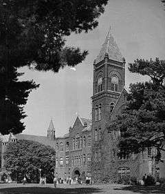
| 8 |
Baity Hall |
|
000000001986-06-25-0000June 25, 1986
(#86001396) |
Missouri Valley College, 500 E. College
39°06′28″N 93°11′23″W / 39.107778°N 93.189722°W / 39.107778; -93.189722 (Baity Hall) |
Marshall |
|
| 9 |
George Caleb Bingham House |
|
000000001966-10-15-0000October 15, 1966
(#66000423) |
1st and High Sts. in Arrow Rock State Park
39°04′15″N 92°56′35″W / 39.070833°N 92.943056°W / 39.070833; -92.943056 (George Caleb Bingham House) |
Arrow Rock |
|
| 10 |
Henry Blosser House |
Upload image |
000000001978-12-29-0000December 29, 1978
(#78001675) |
East of Malta Bend off U.S. 65
39°11′24″N 93°17′28″W / 39.19°N 93.291111°W / 39.19; -93.291111 (Henry Blosser House) |
Malta Bend |
|
| 11 |
Buckner House |
Upload image |
000000001984-04-19-0000April 19, 1984
(#84002581) |
125 N. Brunswick Ave.
39°07′22″N 93°11′25″W / 39.122778°N 93.190278°W / 39.122778; -93.190278 (Buckner House) |
Marshall |
|
| 12 |
Chicago and Alton Depot |
Upload image |
000000001979-06-27-0000June 27, 1979
(#79001395) |
Sebree St.
39°07′31″N 93°11′54″W / 39.125278°N 93.198333°W / 39.125278; -93.198333 (Chicago and Alton Depot) |
Marshall |
|
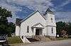
| 13 |
First Christian Church |
|
000000001980-09-12-0000September 12, 1980
(#80002394) |
400 Bridge St.
38°57′46″N 93°25′09″W / 38.962778°N 93.419167°W / 38.962778; -93.419167 (First Christian Church) |
Sweet Springs |
|
| 14 |
First Presbyterian Church |
Upload image |
000000001977-09-20-0000September 20, 1977
(#77000814) |
212 E. North St.
39°07′15″N 93°11′39″W / 39.120833°N 93.194167°W / 39.120833; -93.194167 (First Presbyterian Church) |
Marshall |
|
| 15 |
Fisher-Gabbert Archeological Site |
Upload image |
000000001972-03-16-0000March 16, 1972
(#72000730) |
1 mile (1.6 km) northeast of central Miami[6]
39°19′51″N 93°12′48″W / 39.330833°N 93.213333°W / 39.330833; -93.213333 (Fisher-Gabbert Archeological Site) |
Miami |
|
| 16 |
Fitzgibbon Hospital |
Upload image |
000000002012-10-17-0000October 17, 2012
(#12000874) |
868 S. Brunswick Ave.
39°06′44″N 93°11′25″W / 39.112348°N 93.190284°W / 39.112348; -93.190284 (Fitzgibbon Hospital) |
Marshall |
|
| 17 |
Free Will Baptist Church of Pennytown |
Upload image |
000000001988-04-19-0000April 19, 1988
(#88000388) |
Off MO UU 8 miles (13 km) southeast of Marshall
39°00′59″N 93°10′47″W / 39.016389°N 93.179722°W / 39.016389; -93.179722 (Free Will Baptist Church of Pennytown) |
Marshall |
|
| 18 |
Gumbo Point Archeological Site |
Upload image |
000000001969-08-25-0000August 25, 1969
(#69000125) |
Southern side of the Missouri River, 2 miles (3.2 km) north of the junction of U.S. Route 65 and Route 127[7]
39°13′33″N 93°23′18″W / 39.225833°N 93.388333°W / 39.225833; -93.388333 (Gumbo Point Archeological Site) |
Grand Pass |
|
| 19 |
Guthrey Archeological Site |
Upload image |
000000001970-12-02-0000December 2, 1970
(#70000349) |
2 miles (3.2 km) east of Miami[8]
39°20′04″N 93°11′34″W / 39.334444°N 93.192778°W / 39.334444; -93.192778 (Guthrey Archeological Site) |
Miami |
|
| 20 |
Mt. Carmel Historic District |
Upload image |
000000002009-11-10-0000November 10, 2009
(#09000900) |
290th Rd. and Missouri Highway 41 North
39°12′39″N 93°13′09″W / 39.210726°N 93.219190°W / 39.210726; -93.219190 (Mt. Carmel Historic District) |
Marshall |
|
| 21 |
George A. Murrell House |
Upload image |
000000001997-11-14-0000November 14, 1997
(#97001435) |
0.75 miles (1.21 km) east and 0.5 miles (0.80 km) north of MO E and H
39°02′17″N 93°04′25″W / 39.038056°N 93.073611°W / 39.038056; -93.073611 (George A. Murrell House) |
Napton |
|
| 22 |
Neff Tavern Smokehouse |
Upload image |
000000001978-11-30-0000November 30, 1978
(#78001676) |
Northeast of Napton off MO 41
39°05′48″N 93°02′39″W / 39.096667°N 93.044167°W / 39.096667; -93.044167 (Neff Tavern Smokehouse) |
Napton |
|
| 23 |
Old Fort |
Upload image |
000000001972-01-13-0000January 13, 1972
(#72000731) |
Van Meter State Park[9]
39°16′22″N 93°15′49″W / 39.272778°N 93.263611°W / 39.272778; -93.263611 (Old Fort) |
Miami |
|
| 24 |
Plattner Archeological Site |
Upload image |
000000001971-03-04-0000March 4, 1971
(#71000474) |
1 mile (1.6 km) north of Malta Bend[8]
39°12′38″N 93°21′24″W / 39.210556°N 93.356667°W / 39.210556; -93.356667 (Plattner Archeological Site) |
Malta Bend |
|
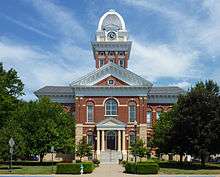
| 25 |
Saline County Courthouse |
|
000000001977-08-24-0000August 24, 1977
(#77000815) |
Courthouse Sq.
39°07′15″N 93°11′47″W / 39.120833°N 93.196389°W / 39.120833; -93.196389 (Saline County Courthouse) |
Marshall |
|
| 26 |
Santa Fe Trail-Grand Pass Trail Segments |
Upload image |
000000001994-04-21-0000April 21, 1994
(#94000324) |
Junction of US 65 and County Road T
39°11′43″N 93°26′29″W / 39.195278°N 93.441389°W / 39.195278; -93.441389 (Santa Fe Trail-Grand Pass Trail Segments) |
Grand Pass |
|
| 27 |
Santa Fe Trail-Saline County Trail Segments |
Upload image |
000000001994-06-30-0000June 30, 1994
(#94000615) |
Co. Rd. 416 (Rural Rt. 3) west of junction with MO 41
39°11′17″N 93°14′21″W / 39.188056°N 93.239167°W / 39.188056; -93.239167 (Santa Fe Trail-Saline County Trail Segments) |
Stanhope |
|
| 28 |
William B. Sappington House |
|
000000001970-01-21-0000January 21, 1970
(#70000348) |
3 miles (4.8 km) southwest of Arrow Rock on CR TT
39°02′24″N 92°59′09″W / 39.04°N 92.985833°W / 39.04; -92.985833 (William B. Sappington House) |
Arrow Rock |
|
| 29 |
Sweet Springs Historic District |
|
000000001997-12-10-0000December 10, 1997
(#97001485) |
200-217 W. Lexington Ave and 211 Marshall St.
38°57′54″N 93°25′04″W / 38.965°N 93.417778°W / 38.965; -93.417778 (Sweet Springs Historic District) |
Sweet Springs |
Originally roughly along Lexington, Marshall, Miller, and Spring Sts., until a boundary decrease of 000000002010-04-26-0000April 26, 2010
|
| 30 |
Utz Site |
Upload image |
000000001966-10-15-0000October 15, 1966
(#66000424) |
Southern half of Section 19, Township 52 North, Range 21 West[8]
39°16′23″N 93°15′12″W / 39.273167°N 93.253333°W / 39.273167; -93.253333 (Utz Site) |
Marshall |
Site is a full mile long from southwest to northeast[8]
|
| 31 |
Van Meter State Park Combination Building |
Upload image |
000000001985-02-27-0000February 27, 1985
(#85000537) |
Van Meter State Park
39°15′53″N 93°16′05″W / 39.264722°N 93.268056°W / 39.264722; -93.268056 (Van Meter State Park Combination Building) |
Marshall |
|
| 32 |
Van Meter State Park Shelter Building |
Upload image |
000000001985-02-28-0000February 28, 1985
(#85000538) |
Van Meter State Park
39°15′57″N 93°16′09″W / 39.265833°N 93.269167°W / 39.265833; -93.269167 (Van Meter State Park Shelter Building) |
Marshall |
|