Mohawk Hudson Bike/Hike Trail
| Mohawk Hudson Hike/Bike Trail | |
|---|---|
|
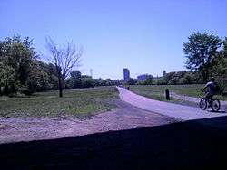
The Corning Tower on the Albany skyline, as seen from the trail's Hudson River section | |
| Length | 86 miles (138 km) |
| Location | Little Falls to Albany, New York |
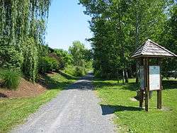
| Trailheads | Little Falls, Fort Plain, Canojaharie, Fultonville, Amsterdam, Patterson, NY Route 5 Park and Ride, Schenectady County Community College, Blatnick Park in Niskayuna, Mohawk View Park in Colonie, 4th Street Park in Watervliet, Corning Preserve in Albany |
| Use | Biking, inline skating, walking, cross-country skiing |
| Hiking details | |
| Trail difficulty | Mostly easy, level, ADA-accessible, with isolated steep grades and occasional on-road sections |
| Season | All year, dawn to dusk |
| Surface | Stone dust, asphalt |
| Right of way | Troy & Schenectady Railroad |
The Mohawk Hudson Hike/Bike Trail (MHBHT) is an 86-mile (138 km) trail in New York's Mohawk Valley and Capital District. It is also the easternmost segment of the New York State Canalway Trail.
The trail starts on the west bank of the Hudson River in the Albany's Erastus Corning City Preserve, and travels northward to Watervliet. From there, an on-street bike route connects through Watervliet, Green Island and Cohoes to the Mohawk River section. The trail continues west along the Mohawk River and New York State Barge Canal, with occasional on-road segments, ending in the Pattersonville section of Rotterdam.
After a 5.7 miles (9.2 km) gap, the trail resumes near Amsterdam, and continues through the communities of Fultonville and Canoajoharie, ending near Little Falls. After a 26-mile gap, the Canalway Trail resumes in Utica.
Much of the MHBHT is a rail trail, created from portions of the Troy & Schenectady Railroad,[1] which was taken out of service on January 15, 1965.[2] Most of the portion from the Northway to Schenectady was still owned by the Penn Central railroad as of 1973.[3]
There are a few gaps in the trail where it leaves the former railbed and follows local roads. One such section crosses under the Thaddeus Kosciusko Bridge, which carries Interstate 87 over the Mohawk River, and another travels through the city of Watervliet and the Village of Green Island, where the width between the Hudson River and Interstate 787 is insufficient for a trail.
It is generally regarded as the Capital District's premier linear park, and is the most heavily used, based on a 2007 survey of trail users. An estimated 241,000 individual user sessions per year occur on the trail.[4]
Bathrooms are available at Rotterdam Kiwanis Park, Niskayuna Lions Park (seasonal), and Corning Preserve. The trail also includes benches, picnic facilities, and parking areas.
References
- ↑ "Mohawk-Hudson Bike-Hike Trail Map 2010". Capital District Transportation Committee. 2010.
- ↑ "Crossing The Northway". Retrieved Dec 15, 2014.
- ↑ "Inventory of Abandoned Railroad Rights-of-Way, Region 1". Albany, New York: New York State Department of Transportation. 1973.
- ↑ "Regional Trail Perspectives: A Survey of Capital District Trail Facilities" (PDF). Albany, New York: Capital District Transportation Committee. 2007.
External links
- 2004 Mohawk-Hudson Bike-Hike Trail Map
- Mohawk-Hudson Bikeway
- Friends of the Mohawk-Hudson Bike-Hike Trail
| Albany |
|    |
|---|---|---|
| Allegany | ||
| Cattaraugus | ||
| Cayuga | ||
| Columbia | ||
| Delaware | ||
| Dutchess | ||
| Franklin | ||
| Livingston | ||
| Monroe |
| |
| New York | ||
| Ontario | ||
| Orange | ||
| Oswego | ||
| Putnam | ||
| Rockland |
| |
| St. Lawrence | ||
| Schenectady | ||
| Ulster | ||
| Westchester | ||
| Wyoming | ||