High Line (New York City)
| High Line | |
|---|---|
|
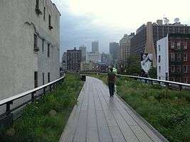
The High Line, an aerial greenway, at 20th Street looking downtown; the vegetation was chosen to pay homage to the wild plants that had colonized the abandoned railway before it was repurposed | |
 Map (2014) | |
| Type | elevated urban linear park; public park |
| Location | Manhattan, New York City |
| Coordinates | 40°44′54″N 74°0′18″W / 40.74833°N 74.00500°W |
| Area | A linear 1.45-mile (2.33 km) stretch of viaduct[1] |
| Created | 2009 |
| Operated by | New York City Department of Parks and Recreation |
| Visitors | 5,000,000 (2014)[2] |
| Status | Open |
| Public transit access |
New York City Subway: 34th Street – Hudson Yards ( New York City Bus: M11, M12, M14A, M14D, M23, M34 SBS at various places |
| Website | www.thehighline.org |
The High Line (also known as the High Line Park) is a 1.45-mile-long (2.33 km) New York City linear park built in Manhattan on an elevated section of a disused New York Central Railroad spur called the West Side Line.[1] Inspired by the 3-mile (4.8-kilometer) Promenade plantée (tree-lined walkway), a similar project in Paris completed in 1993, the High Line has been redesigned and planted as an aerial greenway and rails-to-trails park.[3][4]
The High Line Park is built on the disused southern portion of the West Side Line running to the Lower West Side of Manhattan. It runs from Gansevoort Street – three blocks below 14th Street – in the Meatpacking District, through Chelsea, to the northern edge of the West Side Yard on 34th Street near the Javits Convention Center. An unopened spur extends above 30th Street to Tenth Avenue.[5] Formerly, the West Side Line went as far south as a railroad terminal to Spring Street just north of Canal Street, however most of the lower section was demolished in 1960,[6] with another small portion of the lower section being demolished in 1991.[7]
Repurposing of the railway into an urban park began construction in 2006,[8][9] with the first phase opening in 2009,[10] and the second phase opening in 2011.[11] The third and final phase officially opened to the public on September 21, 2014.[12] A short stub above Tenth Avenue and 30th Street is still closed as of September 2014, but will open by 2017, once the Hudson Yards Redevelopment Project is complete.[13] The project has spurred real estate development in the neighborhoods that lie along the line,[14] and increased real estate values and prices along the route, as a "halo effect".[15] As of September 2014, the park gets nearly 5 million visitors annually.[2]
Description
The park extends from Gansevoort Street to 34th Street. At 30th Street, the elevated tracks turn west around the Hudson Yards Redevelopment Project[16] to the Jacob K. Javits Convention Center on 34th Street,[5] though the northern section is expected to be integrated within the Hudson Yards development [17] and the Hudson Park and Boulevard. When the Hudson Yards Redevelopment Project's Western Rail Yard is finished in 2018, it will be elevated above the High Line Park, so an exit along the viaduct will be located over the West Side Yard, exiting out to the Western Rail Yard of Hudson Yards.[18] The 34th Street entrance is at grade level, and has wheelchair access.[5][18]
The park is open daily from 7 a.m. to 7 p.m. in the winter, 10 p.m. in the spring and fall, and 11 p.m. in the summer, except for the Interim Walkway west of 11th Avenue, which is open until dusk. It can be reached through eleven entrances, five of which are accessible to people with disabilities. The wheelchair-accessible entrances, each with stairs and an elevator, are at Gansevoort, 14th, 16th, 23rd, and 30th Streets. Additional staircase-only entrances are located at 18th, 20th, 26th, and 28th Streets, and 11th Avenue. Street level access is available at 34th Street via an "Interim Walkway" between 30th Street/11th Avenue and 34th Street.[5][19]
Route
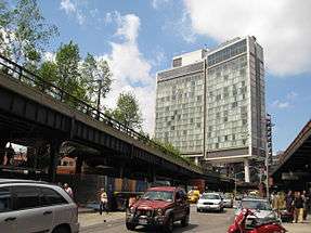
At the Gansevoort Street end, which runs north-south, the stub end over Gansevoort Street is named the Tiffany and Co. Foundation Overlook,[5] dedicated in July 2012; the foundation was a major backer of the park.[20][21] Then, it passes under The Standard hotel,[22][23] and through a passage at 14th Street.[5] At 14th Street, the High Line is split into two sides of different elevations;[24] the Diller-Von Furstenberg Water Feature, opened in 2010, is featured on the lower side, and a sundeck on the upper side.[25]
Then, the High Line passes under the Chelsea Market, a food hall, at 15th Street.[5][26] A spur connecting the viaduct to the National Biscuit Company building splits off at 16th Street; this spur is closed to the public.[24] The Tenth Avenue Square, an amphitheater located on the viaduct, is at 17th Street, where the High Line crosses over Tenth Avenue from southeast to northwest.[5][24] At 23rd Street, there is the 23rd Street Lawn, a lawn where visitors can rest.[5][27] Then, between 25th and 26th Streets, a ramp takes visitors above the viaduct, with a scenic overlook facing east at 26th Street. The Philip Falcone and Lisa Maria Falcone flyover, as it is called, is named after two major donors to the park;[5][24] this ramp was based on plans for a Phase 1 flyover that was never built.[28]
The park then curves west to Phase 3 and merges into the Tenth Avenue Spur, the latter of which stretches over 30th Street to Tenth Avenue and will open in 2017.[13] On Phase 3, there is another ramp taking visitors above the viaduct at 11th Avenue, as well as a play area consisting of rail ties and modified, silicone-covered beams and stanchions coming out of the structure called the "Pershing Beams", a gathering space with multiple benches, and a set of three trackways where one could walk between the railway tracks.[29][30][31] There is also a seesaw-like bench, as well as a "chime bench", with keys that make sounds when tapped.[1] An "interim walkway" between 11th Avenue and 30th Street and 34th Street divides the viaduct into two sides – a gravel walkway and an un-renovated section still with rail tracks; this walkway is open only temporarily, and will close for renovation once the Tenth Avenue spur is completed.[32] The High Line turns north to a point just east of Twelfth Avenue. At 34th Street, it curves east while descending, ending at street level midway between 12th and 11th Avenues.[5]

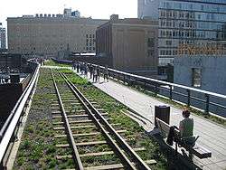
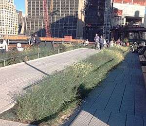
The park's attractions include naturalized plantings that are inspired by the landscape that grew on the disused tracks,[33] and views of the city and the Hudson River. The trail is made of pebble-dash concrete walkways that swells and constricts, swings from side to side, and divides into concrete tines that meld the hardscape with the planting embedded in railroad gravel mulch. Stretches of track and ties recall the High Line's former use. Portions of track are adaptively re-used for rolling lounges positioned for river views.[34] Most of the planting, which includes 210 species, is of rugged meadow plants, including clump-forming grasses, liatris, and coneflowers, with scattered stands of sumac and smokebush, but not limited to American natives. At the Gansevoort Street end, a grove of mixed species of birch already provides some dappled shade by late afternoon. Ipê timber for the built-in benches has come from a managed forest certified by the Forest Stewardship Council, to ensure sustainable use and the conservation of biological diversity, water resources, and fragile ecosystems.[35]
The High Line Park also has cultural attractions. As part of a long-term plan for the park to host temporary installations and performances of various kinds. Creative Time, Friends of the High Line, and the New York City Department of Parks and Recreation commissioned The River That Flows Both Ways by Spencer Finch as the inaugural art installation. The work is integrated into the window bays of the former Nabisco Factory loading dock, as a series of 700 purple and grey colored glass panes. Each color is exactly calibrated to match the center pixel of 700 digital pictures, one taken every minute, of the Hudson River, therefore presenting an extended portrait of the river that gives the work its name. Creative Time worked with the artist to realize the site-specific concept that emerged when he saw the rusted, disused mullions of the old factory, which metal and glass specialists Jaroff Design helped to prepare and reinstall.[36]
The summer of 2010 featured a sound installation by Stephen Vitiello, composed from bells heard through New York. Lauren Ross, formerly director of the alternative art space White Columns, served as the first curator for the High Line Park.[37] During the construction of the second phase between 20th and 30th Streets, several artworks were installed including, Sarah Sze's "Still Life with Landscape (Model for a Habitat)" a sculpture made of steel and wood, located on the line near 20th and 21st Streets; this structure was built as a house for fauna such as birds and butterflies. Kim Beck's "Space Available"[38] was installed on the roofs of three buildings visible from the southern end. Three 20-by-12-foot (6.1 by 3.7 m) sculptures looked like the armature of empty billboards, constructed like theater backdrops, so they look three-dimensional from a distance.[39][40] Also installed during the second phase of construction was Julianne Swartz's "Digital Empathy", a work that utilizes audio messages at restrooms, elevators, and water fountains.[41]
History
Rail line
In 1847, the City of New York authorized street-level railroad tracks down Manhattan's West Side to ship freight.[42] For safety, the railroads hired men called the "West Side Cowboys" to ride horses and wave flags in front of the trains.[43] However, so many accidents occurred between freight trains and other traffic that Tenth Avenue became known as "Death Avenue".[44][45]
After years of public debate about the hazard, in 1929 the city, the state of New York, and the New York Central Railroad agreed on the West Side Improvement Project,[42] a large project conceived by Robert Moses that also included the construction of the West Side Elevated Highway.[46] The 13-mile (21 km) project eliminated 105 street-level railroad crossings and added 32 acres (13 ha) to Riverside Park. It cost more than US$150,000,000 (about US$2,070,640,000 today).[43][45]
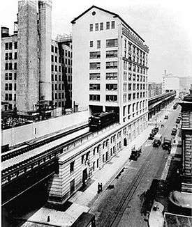
The High Line viaduct, then a portion of the New York Central Railroad's West Side Line, opened to trains in 1934. It originally ran from 34th Street to St. John's Park Terminal at Spring Street, and was designed to go through the center of blocks rather than over the avenue.[43] It connected directly to factories and warehouses, allowing trains to load and unload their cargo inside buildings. Milk, meat, produce, and raw and manufactured goods could be transported and unloaded without disturbing traffic on the streets.[43] This also reduced the load for the Bell Laboratories Building (which has housed the Westbeth Artists Community since 1970[47]), as well as for the former Nabisco plant in the Chelsea Market building, which were served from protected sidings within the structures.[45][48]
The train also passed underneath the Western Electric complex at Washington Street. This section still exists as of May 18, 2008, and is not connected with the rest of the developed park.[45][49]
The growth of interstate trucking in the 1950s led to a drop in rail traffic throughout the nation. By 1960, the southernmost section of the line was demolished due to low use.[6] This section started at Gansevoort Street and ran down Washington Street as far as Spring Street just north of Canal Street,[50] representing almost half of the line. The last train on the remaining part of the line was operated by Conrail in 1980.[43][45]
In the mid-1980s, a group of property owners with land under the line lobbied for the demolition of the entire structure. Peter Obletz, a Chelsea resident, activist, and railroad enthusiast, challenged the demolition efforts in court and tried to re-establish rail service on the line.[43][51] However, during the late 1980s, the north end of the High Line was disconnected from the rest of the national railroad system because it was expected that the High Line would be demolished.[52] Due to the construction of the Empire Connection to Penn Station, which opened in spring 1991, new tracks were routed to the new Empire Connection tunnel built underground to Penn Station. A small section of the High Line in the West Village, from Bank to Gansevoort Streets, was taken apart in 1991, despite objections by people who wanted to keep the High Line.[7]
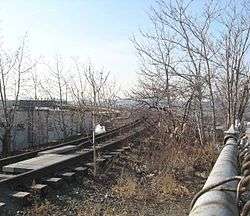
In the 1990s, as the line lay unused and in disrepair (despite the fact that the riveted-steel elevated structure was structurally sound) it became known to a few urban explorers and local residents for the tough, drought-tolerant wild grasses, shrubs, and rugged trees such as sumac that had sprung up in the gravel along the abandoned railway. It was slated for demolition under the administration of then-mayor Rudy Giuliani.[45][53]
Repurposing
In 1999, the nonprofit organization Friends of the High Line [43] was formed by Joshua David and Robert Hammond, residents of the neighborhood that the line ran through. They advocated for the line's preservation and reuse as public open space, so that it would become an elevated park or greenway, similar to the Promenade Plantée in Paris.[54][55] CSX Transportation, which owned the High Line, had given photographer Joel Sternfeld permission to photograph the line for a year. These photographs of the natural beauty of the meadow-like wildscape of the railway, discussed in an episode of the documentary series Great Museums, were used at public meetings whenever the subject of saving the High Line was discussed.[56] Fashion designer Diane von Fürstenberg, who had moved her New York City headquarters to the Meatpacking District in 1997, organized fund-raising events for the campaign in her studio, along with her husband, Barry Diller.[56] Broadened community support of public redevelopment of the High Line for pedestrian use grew, and in 2004, the New York City government committed $50 million to establish the proposed park. New York Mayor Michael Bloomberg and City Council Speakers Gifford Miller and Christine C. Quinn were important supporters. In total, funders of the High Line Park raised more than $150 million (equivalent to $165,728,000 in 2015).[57]
On June 13, 2005, the U.S. Federal Surface Transportation Board issued a certificate of interim trail use, allowing the city to remove most of the line from the national railway system. On April 10, 2006, Mayor Bloomberg presided over a ceremony that marked the beginning of construction. The park was designed by the James Corner's New York-based landscape architecture firm Field Operations and architects Diller Scofidio + Renfro, with garden design from Piet Oudolf of the Netherlands, lighting design from L'Observatoire International,[8] and engineering design by Buro Happold.[9] The New York City Department of City Planning director and Chair of the City Planning Commission Amanda Burden actively contributed to the success of project development.
Major backers included Philip Falcone,[58] Diane von Fürstenberg, Barry Diller, and von Fürstenberg's children, Alexander von Fürstenberg and Tatiana von Fürstenberg.[59] Hotel developer Andre Balazs, owner of the Chateau Marmont in Los Angeles, built the 337-room Standard Hotel, straddling the High Line at West 13th Street.[22]
The southernmost section, from Gansevoort Street to 20th Street, opened as a city park on June 8, 2009.[10] This southern section includes five stairways and elevators at 14th Street and 16th Street.[5] Around the same time, construction for the second section began.[60]
On June 7, 2011, a ribbon was cut to open the second section from 20th Street to 30th Street, with Mayor Michael Bloomberg, New York City Council Speaker Christine Quinn, Manhattan Borough President Scott Stringer, and Congressman Jerrold Nadler in attendance.[11][61]
In 2011, CSX Transportation, the then-owner of the northernmost section, from 30th to 34th Streets, agreed in principle to donate the section to the city,[59] while the Related Companies, which owns the development rights to the West Side Rail Yards, agreed not to tear down the spur that crosses 10th Avenue.[62] Construction on the final section was started in September 2012.[63][64]

On September 20, 2014, a ribbon-cutting ceremony for the High Line was held,[12][65] followed by the opening of the third section of the High Line Park on September 21, and a procession down the High Line.[2][66] The third phase, costing US$76 million, is divided into two parts.[18] The first part, costing US$75 million,[67] which opened on September 21,[12] is from the end of the existing Phase 2 of the High Line to the line's terminus at 34th Street west of 11th Avenue.[18][68][69] The second part, the spur, was going to contain such amenities as a bowl-shaped theater but has changed and will provide more room to install ambitious artworks curated by the public art program. The Spur will also provide much-needed storage space for park operations, maintenance, and horticulture, as well as additional public restrooms .[70][71][72][73] It will also be integrated with 10 Hudson Yards,[74] which has already been built over the High Line Spur as of December 2013;[75] the spur will not open until sometime in 2017.[70][72]
Impact
The recycling of the railway into an urban park has brought on the revitalization of Chelsea, which had been "gritty" and in generally poor condition in the late twentieth century.[76] It has also spurred real estate development in the neighborhoods that lie along the line.[14] Mayor Bloomberg noted that the High Line project has helped usher in something of a renaissance in the neighborhood: by 2009, more than 30 projects were planned or under construction nearby,[10] and by 2016, more than 11 projects were under construction.[77] It has also helped to raise the prices of properties directly adjacent to the High Line by an average of 10% compared to properties located a few blocks away. Since the park's opening in 2009, there have been at least 20 properties abutting the High Line that have sold for at least $10 million, with the average apartment in a building directly adjacent to the park selling for $6 million.[77] Apartments located near Phase 1 of the High Line are, on average, more than twice as costly as apartments located between Seventh and Eighth Avenues, two blocks to the east.[78] As of August 2016, the park has continued to increase real estate values and prices along the route, as a "halo effect".[15]
Residents who have bought apartments next to the High Line Park have adapted to its presence in varying ways, but most responses are positive; some, however, claim that the park became a "tourist-clogged catwalk" since it opened.[27] The real estate boom has not been victimless, however, many well-established businesses in west Chelsea have closed due to loss of neighborhood customer base or rent increases.[79]
Crime has been very low in the park. Shortly after the second section opened in 2011, The New York Times reported that there have been no reports of major crimes such as assaults or robberies since its first phase opened two years prior. Parks Enforcement Patrols have written summonses for various infractions of park rules, such as walking dogs or riding bicycles on the walkway, but at a rate lower than in Central Park. Park advocates attributed that to the high visibility of the High Line from the surrounding buildings, a feature of traditional urbanism espoused by author Jane Jacobs nearly fifty years earlier. According to Joshua David, a co-founder of Friends of the High Line, "Empty parks are dangerous ... Busy parks are much less so. You're virtually never alone on the High Line."[80]
A New Yorker columnist, in a review of the Highliner restaurant (which took over the space of the classic Empire Diner), complained that "the new Chelsea that is emerging on weekends as visitors flood the elevated park... [as] touristy, overpriced, and shiny."[81]
The success of the High Line in New York City has encouraged the leaders of other cities, such as Mayor Rahm Emanuel of Chicago, who see it as "a symbol and catalyst" for gentrifying neighborhoods.[82] Several cities also have plans to renovate some railroad infrastructure into park land, including Philadelphia and St. Louis. In Chicago, where the Bloomingdale Trail, a 2.7-mile (4.3 km) long linear park on former railroad infrastructure, will run through several neighborhoods. One estimate is that it costs substantially less to redevelop an abandoned urban rail line into a linear park than to demolish it.[82] James Corner, one of the Bloomingdale Trail's designers, said, "The High Line is not easily replicable in other cities," observing that building a "cool park" requires a "framework" of neighborhoods around it in order to succeed.[82] In Queens, the Queensway, a proposed aerial rail trail, is being considered for reactivation along the right-of-way of the former LIRR Rockaway Beach Branch.[83] Other cities around the world are planning elevated rails-to-trails parks, with one writer calling this the "High Line effect".[84]
Due to the popularity of the High Line, there have been several proposals for museums along its path. The Dia Art Foundation considered, but rejected, a proposal to build a museum at the Gansevoort Street terminus.[85] On that site, the Whitney Museum has built a new home for its collection of American art. The building was designed by Renzo Piano and opened on May 1, 2015.[86]
In popular culture
The High Line has been depicted in numerous media works, before and after its redevelopment. The 1979 film Manhattan included a shot of the High Line, as director and star Woody Allen speaks the first line: "Chapter One. He adored New York City."[87] Director Zbigniew Rybczyński shot the video for Art Of Noise's recording Close (to the Edit) on the High Line in 1984.[88]
In 2001, two years after the formation of the nonprofit Friends of the High Line, photographer Joel Sternfeld documented the dilapidated conditions and the natural flora of the line in his book Walking the High Line. The book also contained essays by writer Adam Gopnik and historian John R. Stilgoe.[89] Sternfeld's work was regularly discussed and exhibited during the 2000s as the rehabilitation project moved forward.[56] In a similar vein, Alan Weisman's 2007 book The World Without Us discussed the High Line as an example of the reappearance of the wild in an abandoned area.[90] That same year chase scenes from the zombie apocalypse film I Am Legend were filmed there and in the Meatpacking District.[91][92] The 2009 hip-hop song "The High Line" by Kinetics & One Love is a pro-green song that uses the High Line, before its conversion into a park, as an example of nature's reclamation of man-made structures.[93]
With the opening of the High Line Park, many films and television shows have set sequences there. In 2011, the television series Louie used the High Line as a setting for one of the title character's dates.[94] Other works to set scenes on the High Line since it opened include the HBO series Girls, the Simpsons episode "Moonshine River", and the film What Maisie Knew.[92][95][96]
Gallery
- The High Line
.jpg) Foliage
Foliage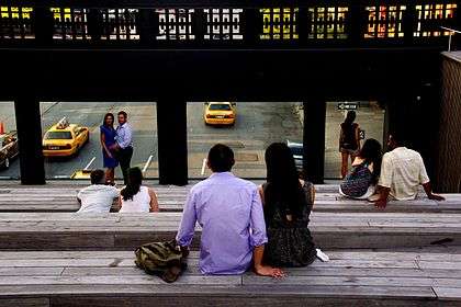 Urban theater
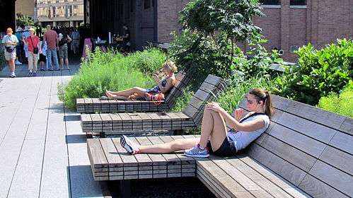 Relaxing
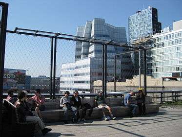
See also
Similar parks:
- The 606, Chicago, Illinois
- Beltline Trail, Toronto, Ontario
- Beltline, Atlanta, Georgia
- Freedom Park, Arlington, Virginia
- Greenway, London
- Harsimus Stem Embankment, Jersey City, New Jersey
- Hofpleinlijnviaduct (Dutch), Hofbogen, Rotterdam, The Netherlands (under construction)
- Katy Trail, Dallas, Texas
- Klyde Warren Park, Dallas, Texas
- Lowline, Lower Manhattan
- Maidashi ryokuchi, Fukuoka, Japan
- München Olympiastadion station, Munich, Germany (proposed)
- Old 11th Street Bridge, Washington, DC
- Parkland Walk, London
- Promenade plantée, Paris, France
- Rails-to-Trails Conservancy
- Reading Viaduct, Philadelphia, Pennsylvania
- Cheonggyecheon, Seoul, South Korea
- The Goods Line, Sydney, Australia
Neighborhoods, developments, and places nearby:
References
Notes
- 1 2 3 F. Green and C. Letsch (September 21, 2014). "New High Line section opens, extending the park to 34th St.". Daily News. Retrieved September 21, 2014.
- 1 2 3 Geiger, Daniel (September 21, 2014). "High Line's high returns". Crain's New York. Retrieved September 21, 2014.
- ↑ "Paris Elevated Rail Park Featured in Movie 'Before Sunset'". Friends of the High Line. August 12, 2004. Archived from the original on June 19, 2010. Retrieved July 27, 2014.
- ↑ "An elevated park à la française". Friends of the High Line. February 1, 2012. Archived from the original on February 5, 2012. Retrieved July 27, 2014.
- 1 2 3 4 5 6 7 8 9 10 11 12 "High Line Map" (PDF). Friends of the High Line.
- 1 2 "The High Line". NYC Architecture.
- 1 2 "Elevated Freight Line Being Razed Amid Protests". The New York Times. January 15, 1991. Retrieved October 23, 2014.
- 1 2 "The Business of The High Line". Inc. October 2011. Retrieved September 5, 2012.
- 1 2 "High Line". BuroHappold Engineering. Retrieved November 27, 2009.
- 1 2 3 Pogrebin, Robin (June 8, 2009). "First Phase of High Line Is Ready for Strolling". The New York Times. Retrieved July 8, 2009.
- 1 2 Pesce, Nicole Lyn (June 7, 2011). "Hotly anticipated second section of the High Line opens, adding 10 blocks of elevated park space". Daily News. Retrieved June 7, 2011.
- 1 2 3 "Third and Final Phase Opens". The New York Times. September 20, 2014. Retrieved September 20, 2014.
- 1 2 Jessica Dailey (September 4, 2014). "Final Section of the High Line Will Open on September 21". Curbed. Retrieved September 9, 2014.
- 1 2 Gregor, Alison (August 10, 2010). "As a Park Runs Above, Deals Stir Below". The New York Times. Retrieved February 10, 2011.
- 1 2 Pereira, Ivan (August 8, 2016). "High Line, higher prices: Housing $oars (sic.) near elevated park (print version); High Line spurs jump in nearby home prices: Streeteasy (online version)". AM New York. Retrieved August 10, 2016.
- ↑ Topousis, Tom (December 8, 2006). "Rail Shot at Prosperity". New York Post. Retrieved August 2, 2009.
- ↑ "10 Hudson Yards Building Plan". Hudson Yards Redevelopment Project. January 22, 2014. Retrieved April 1, 2014.
- 1 2 3 4 "Hudson Yards Set to Alter Skyline, Transform Neighborhood". Chelsea Now. February 6, 2013. Retrieved June 2, 2014.
- ↑ "Park Information". Friends of the High Line. June 8, 2011. Retrieved September 20, 2014.
- ↑ Laylin, Tafline (July 24, 2012). "Mayor Bloomberg Cuts Ribbon on the High Line's Newly Renamed Tiffany & Co. Foundation Overlook". Inhabitat. Retrieved September 21, 2014.
- ↑ "The Tiffany and Co. Foundation Overlook Dedicated on the High Line". Tiffany and Co. Foundation. July 2012. Retrieved September 21, 2014.
- 1 2 Ouroussoff, Nicolai (April 8, 2009). "Industrial Sleek (a Park Runs Through It)". The New York Times. Retrieved April 9, 2009.
- ↑ "Polshek Partnership". Emap Construct. Retrieved April 25, 2013.
- 1 2 3 4 Walsh, Kevin (September 2011). "HIGH LINE 2011: Rail to trail opens from 20th to 30th Streets". Forgotten NY. Retrieved September 21, 2014.
- ↑ "New Water Feature Coming to the High Line". Friends of the High Line. April 22, 2010. Archived from the original on June 16, 2010. Retrieved September 21, 2014.
- ↑ "About Chelsea Market", Chelsea Market website. Retrieved September 21, 2014.
- 1 2 Kurutz, Steven (August 1, 2012). "Close Quarters". The New York Times. Retrieved August 17, 2014.
- ↑ "More Room to Roam on the High Line". The New York Times. May 29, 2011. Retrieved September 21, 2014.
- ↑ Walsh, Kevin J. (October 2014). "LAST OF THE HIGH LINE, Chelsea". Forgotten NY. Retrieved 16 November 2014.
- ↑ Mullanney, Jeanette (October 23, 2014). "Exploring New Design Features at the Rail Yards". Friends of the High Line. Retrieved October 23, 2014.
- ↑ Rosenberg, Zoe (September 20, 2014). "Say Hello to High Line at the Rail Yards, the Park's Final Leg". Curbed. Retrieved September 21, 2014.
- ↑ Davidson, Justin (September 20, 2014). "The High Line's Last Section Opens Tomorrow, and Here's a First Look". New York. Retrieved September 21, 2014.
- ↑ "Planting Design". Friends of the High Line. Archived from the original on April 2, 2010. Retrieved August 2, 2009.
- ↑ "Construction". Friends of the High Line. Archived from the original on March 28, 2010. Retrieved August 17, 2014.
- ↑ "Wood on the High Line". Friends of the High Line. Archived from the original on October 28, 2009. Retrieved August 2, 2009.
- ↑ Vogel, Carol (May 21, 2009). "Seeing the Hudson River Through 700 Windows". The New York Times. Retrieved July 2, 2011.
- ↑ Dobrzynski, Judith H. (May 21, 2009). "Taking the High Line: the art park that rivals MoMA". The Art Newspaper. Retrieved July 2, 2011.
- ↑ "High Line Art: Kim Beck, Space Available". artforum.com. Retrieved 2016-02-27.
- ↑ "Kim Beck Riffs on Meatpacking Ads With Empty Signs - News - Art in America". www.artinamericamagazine.com. Retrieved 2016-02-27.
- ↑ "BOMB Magazine — Friends of the High Line by Tabitha Piseno". bombmagazine.org. Retrieved 2016-02-27.
- ↑ Browne, Alex (June 7, 2011). "High Notes – New Art on the High Line". The New York Times. Retrieved June 7, 2011.
- 1 2 "The Highline: past and present". GeoWeb, Harvard University. May 13, 2010. Retrieved October 23, 2014.
- 1 2 3 4 5 6 7 "High Line History". Friends of the High Line. Retrieved August 2, 2009.
- ↑ Gray, Christopher (December 22, 2011). "When a Monster Plied the West Side". The New York Times. Retrieved May 12, 2014.
The New York World referred to the West Side route as Death Avenue in 1892, long after the Park Avenue problem had been solved, saying 'many had been sacrificed' to 'a monster which has menaced them night and day.'
- 1 2 3 4 5 6 Amateau, Albert. "Newspaper was there at High Line's birth and now its rebirth". The Villager. 77 (48). Retrieved August 12, 2011.
- ↑ Walsh, Kevin (September 2012). ""High Line"'s Last Frontier". Forgotten NY. Retrieved October 23, 2014.
- ↑ Shockley, Jay. "Bell Telephone Laboratories (Westbeth Artists' Housing) Designation Report", New York City Landmarks Preservation Commission (October 25, 2011)
- ↑ "History". Chelsea Market. Archived from the original on July 9, 2010. Retrieved July 14, 2010.
In 1932, the architect Louis Wirsching Jr. replaced some of the 1890 bakeries on the east side of 10th Avenue with the present unusual structure, which accommodates an elevated freight railroad viaduct. Its great open porch on the second and third floors was taken by the railroad as an easement for the rail tracks that still run through it.
- ↑ Gray, Christopher (May 18, 2008). "As High Line Park Rises, a Time Capsule Remains". The New York Times. Retrieved June 11, 2011.
- ↑ "West Side Line & Selkurk Hurdle". Chris Whong. April 3, 2013.
Map of New York Central's West Side Line.
- ↑ Freeman, John (May 13, 2007). "The Charming Gadfly Who Saved the High Line". The New York Times. Retrieved August 12, 2011.
- ↑ Voboril, Mary (March 26, 2005). "The Air Above Rail Yards Still Free". Newsday. New York.
- ↑ Goldberger, Paul (May 15, 2012). "Miracle Above Manhattan". National Geographic. Retrieved May 16, 2014.
- ↑ "Q&A: Friends of the High Line interview". CNN. March 19, 2007. Retrieved September 13, 2014.
- ↑ Owen, Paul (November 18, 2008). "New York's historic elevated train line becomes a park". The Guardian. Archived from the original on August 29, 2014. Retrieved September 13, 2014.
- 1 2 3 Doyle, Chesney; Spann, Susan (2014). "Elevated Thinking: The High Line in New York City". Great Museums.
- ↑ "Trail of the Month, October 2011". Rails-to-Trails Conservancy.
- ↑ Robin Pogrebin, Philanthropist With a Sense of Timing Raises Her Profile, The New York Times, June 29, 2009. Accessed June 27, 2012
- 1 2 Taylor, Kate (November 1, 2011). "Coach Inc. Agrees to Occupy Third of Hudson Yards Tower". The New York Times. Retrieved November 28, 2011.
- ↑ Chan, Sewell (June 25, 2008). "High Line Designs Are Unveiled". The New York Times. Retrieved August 12, 2011.
- ↑ Marritz, Ilya (June 7, 2011). "As the High Line Grows, Business Falls in Love with a Public Park". WNYC. Retrieved June 8, 2011.
- ↑ Keith, Kelsey (November 1, 2011). "Third Section of High Line Is On The Docket, On Google Maps". Curbed. Retrieved September 10, 2014.
- ↑ Katz, Mathew (September 20, 2012). "High Line Begins Construction On Third And Final Section (PHOTOS)". Huffington Post. Retrieved May 9, 2014.
- ↑ "High Line at the Rail Yards". Friends of the High Line. Retrieved May 12, 2014.
- ↑ "Opening Ceremony Celebrates Completion Of High Line Park". CBS New York. September 20, 2014. Retrieved September 21, 2014.
- ↑ "Photos: High Line Phase Three is Officially Open". Gothamist. September 21, 2014. Retrieved September 21, 2014.
- ↑ Raver, Anne (September 3, 2014). "Upstairs, a Walk on the Wild Side". The New York Times. Retrieved September 10, 2014.
- ↑ "High Line at the Rail Yards Opening September 21". Friends of the High Line. September 4, 2014. Retrieved September 4, 2014.
- ↑ "The High Line's Final Section Will Open This Month". Gothamist. September 4, 2014. Retrieved September 9, 2014.
- 1 2 Alberts, Hana R. (November 12, 2013). "Here Now, The Giant, Verdant Bowl In The Next High Line Phase - Rendering Reveals". Curbed. Retrieved May 12, 2014.
- ↑ "High Line Park will be capped with a giant bowl theater". New York Daily News. Retrieved May 12, 2014.
- 1 2 Friends of the High Line (February 18, 2016). "New Design Concept for the Spur".
- ↑ "High Line Park will be capped with a giant bowl theater". New York Daily News. Retrieved February 18, 2016.
- ↑ "10 Hudson Yards fact sheet" (PDF). Hudson Yards Redevelopment Project. Retrieved September 10, 2014.
- ↑ Fedak, Nikolai (December 13, 2013). "Construction Update: 10 Hudson Yards". New York YIMBY. Retrieved May 12, 2014.
- ↑ Koblin, John (April 2, 2007). "High Line Park Spurs Remaking Of Formerly Grotty Chelsea". The New York Observer. Retrieved August 12, 2011.
- 1 2 Barbanel, Josh (2016-08-07). "The High Line's 'Halo Effect' on Property". Wall Street Journal. ISSN 0099-9660. Retrieved 2016-08-08.
- ↑ Nonko, Emily (2016-08-08). "Condos padding the High Line are ridiculously pricier than their neighbors". Curbed NY. Retrieved 2016-08-08.
- ↑ Moss, Jeremiah (August 21, 2012). "Disney World on the Hudson". The New York Times. Retrieved August 22, 2012.
- ↑ Wilson, Michael (June 10, 2011). "The Park Is Elevated. Its Crime Rate Is Anything But". The New York Times. Retrieved June 11, 2011.
- ↑ Levy, Ariel (August 8, 2011). "The Highliner". The New Yorker. Retrieved August 3, 2011.
- 1 2 3 Shevory, Kristina (August 3, 2011). "Cities See the Other Side of the Tracks". The New York Times. Retrieved August 3, 2011.
- ↑ Foderado, Lisa W. (January 7, 2013). "In Queens, Taking the High Line as a Model". The New York Times. Retrieved October 23, 2014.
- ↑ McGinn, Dave (October 1, 2014). "The High Line Effect: Why Cities Around The World (Including Toronto) Are Building Parks in the Sky". The Globe and Mail. Retrieved October 24, 2014.
- ↑ Vogel, Carol (October 25, 2006). "Dia Art Foundation Calls Off Museum Project". The New York Times. Retrieved July 8, 2009.
- ↑ Smith, Roberta (April 30, 2015). "New Whitney Museum Signifies a Changing New York Art Scene". New York Times.
- ↑ "Chapter One: He Adored the High Line". Friends of the High Line. February 21, 2008. Archived from the original on June 16, 2010. Retrieved September 9, 2014. See also: the corresponding video on YouTube
- ↑ Andrew Berman (May 23, 2011). "It Happened Here: 80s Music Videos". Greenwich Village Society for Historic Preservation. Retrieved September 9, 2014.
- ↑ Sternfeld, Joel; Stilgoe, John R.; Gopnik, Adam (2001). Walking the High Line. New York: Steidl/Pace/MacGill Gallery. ISBN 978-3-88243-726-3.
- ↑ "The High Line Without Us". Friends of the High Line. Archived from the original on March 14, 2010. Retrieved September 9, 2014.
- ↑ "I Am Legend film locations". The Worldwide Guide To Movie Locations. Retrieved September 9, 2014.
- 1 2 Sheppard-Vaughn, Danette (March 5, 2013). "Tourism Tuesday Featuring New York City High Line". Royal Limos New York. Retrieved September 9, 2014.
- ↑ Kinetics & One Love - The High Line on YouTube
- ↑ DeLucia, Greg (June 15, 2012). "The "Louie" Map of New York". Splitsider. Retrieved September 9, 2014.
- ↑ Wood, Megan (March 9, 2013). "A 'Girls' Guide to New York". NewYork.com. Retrieved September 9, 2014.
- ↑ Ty Burr (May 23, 2013). "'What Maisie Knew' invites us to see the world through her eyes". The Boston Globe. Retrieved September 9, 2014.
Other sources
- "Q&A: Friends of the High Line interview". CNN.com. March 19, 2007.
- David, Joshua; Hammond, Robert (2011). High Line: The Inside Story of New York City's Park in the Sky. New York: Farrar, Straus and Giroux. ISBN 0-374-53299-0.
- Davidson, Justin (June 7, 2009). "Elevated". New York.
- Maher, Michael (October 7, 2011). "Millions stroll in New York's 'park in the sky'". BBC News (Video).
- Sternbergh, Adam (April 29, 2007). "The High Line: It Brings Good Things to Life". New York.
- Zambelli, Matteo; Alves, Henrique Pessoa (2012). La High Line di New York. Milano: Mimesis. ISBN 978-88-575-0705-7.
External links
| Wikimedia Commons has media related to High Line (New York City). |
| ||||||||||||||||||||||||||||||||||||||||||||||||||||||||||||||||||||||||||||||||||||||||||||||||||||||||||||||||||||||||||||||||||||||||||||||||||||||||||||||||||||||||||||||||||||||||||||