New York State Canal System
|
New York State Barge Canal | |
|
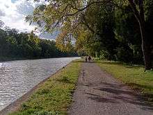
Lock 30 at Macedon, 2006 | |
| Location | 17 counties in upstate New York |
|---|---|
| Area | 36.7 square miles (95 km2) |
| Built | 1905–63 |
| Architect | New York State Engineer’s and Surveyor’s Office: Edward Bond Austin, Frank Martin Williams, David Alexander Watt, A.A. Conger, William R. Davis |
| NRHP Reference # | 14000860[1] |
| Added to NRHP | October 15, 2014 |

The New York State Canal System (formerly known as the New York State Barge Canal) is a successor to the Erie Canal and other canals within New York. Currently, the 525-mile (845 km) system is composed of the Erie Canal, the Oswego Canal, the Cayuga–Seneca Canal, and the Champlain Canal.[2] In 2014 the system was listed as a national historic district on the National Register of Historic Places in its entirety.[1]
The Erie Canal connects the Hudson River to Lake Erie; the Cayuga–Seneca Canal connects Seneca Lake and Cayuga Lake to the Erie Canal; the Oswego Canal connects the Erie Canal to Lake Ontario; and the Champlain Canal connects the Hudson River to Lake Champlain.
History
In 1903 New York State legislature authorized construction of the "New York State Barge Canal" as the "Improvement of the Erie, the Oswego, the Champlain and the Cayuga and Seneca Canals".[3] In 1905, construction of the Barge Canal began; it was completed in 1918, at a cost of $96.7 million.[4] The Barge Canal's new route took advantage of rivers (such as the Mohawk River, Oswego River, Seneca River, Genesee River and Clyde River) that the original Erie Canal builders had avoided, thus bypassing some major cities formerly on the route, such as Syracuse and Rochester. However, particularly in western New York State, the canal system uses the same (enlarged) channel as the original Erie Canal. In 1924 the Barge Canal built the Gowanus Bay Terminal in Brooklyn to handle canal cargo.[5][6]
Since the 1970s, the state has ceased modernizing the system due to the shift to truck transport. The canal is preserved primarily for historical and recreational purposes. Today, very few commercial vessels use the canal; it is mainly used by private pleasure boats, although it also serves as a method of controlling floods. The last regularly scheduled commercial ship operating on the canal was the Day Peckinpaugh, which ceased operation in 1994.[7]
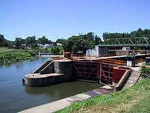
Since 1992, the Barge Canal is no longer known by that name. Individual canals in the New York State Canal System, formerly collectively known as "the Barge Canal," are now referred to by their original names (Erie Canal, Oswego Canal, Cayuga–Seneca Canal, and Champlain Canal). Today, the system's canals are 12 feet (3.7 m) deep and 120 feet (37 m) wide, with 57 electrically operated locks, and can accommodate vessels up to 2,000 tons (1,800 metric tons). The canal system is open for navigation generally from May 1 through November 15.
Financial support of the canal system is from tolls collected on the New York State Thruway; since 1992, it is operated by the Thruway Authority's Canal Recreationway Commission. The application of tolls to support the canal and other non-thruway projects is a matter of controversy. Payment of a fee for a permit is required to transverse the locks and lift bridges with motorized craft.[8]
In 2004, the New York State Canal Corporation reported a total of 122,034 recreational lockings on the canal, along with 8,514 tour boat lockings and 7,369 hire boat lockings, and a total of 12,182 tons of cargo valued at approximately $102 million was shipped on the canal system.
In 2012, the system's annual cargo volume reached 42,000 tons.[9]
Travel on the Canal's middle section (particularly in the Mohawk River valley) was severely hampered during destructive flooding in Upstate New York in late June and early July 2006. Flood damage to the canal system and its facilities was estimated to be at least $15 million.
In 2011, newly elected Governor Andrew Cuomo appointed Schenectady Mayor Brian Stratton as director of the Canal Corporation, which runs the Canal System.
At the end of August 2011 Tropical Storm Irene caused closure of almost the entire canal due to flooding.[10] At the beginning of September 2011, Tropical Storm Lee added more flooding to the system. Damage to several locks was severe enough to close the canal from Lock 8 (Scotia) through Lock 17 (Little Falls) from late August.[11] The canal was fully open for the start of the 2012 navigation season.[12]
Funding and maintenance
The New York State Canal Corporation, a subsidiary of the New York State Thruway Authority, is responsible for the oversight, administration and maintenance of the New York State Canal System.[2] In 2012, the Canal Corp. employed 529 people, consisting of 458 full-time employees and 78 seasonal workers. Its spending accounted for about 10 percent of the Thruway Authority's total $1.1 billion in annual spending. In 2012, the Canal Corp.’s operating budget was $55.7 million and its capital budget was $51.4 million.[13]
An August 2012 report by state Comptroller Thomas DiNapoli said the canal system "contributed to the deterioration of the Authority's financial condition over the past decade", even as canal traffic had dropped nearly one-third since the period immediately before the Thruway Authority assumed control.[14]
See also
- List of canals in New York
- List of navigation authorities in the United States
- National Register of Historic Places in New York
References
- 1 2 "National Register of Historic Places listings for October 24, 2014". U.S. National Park Service. October 24, 2014. Retrieved October 26, 2014.
- 1 2 "About the Canal Corporation". New York State Canal Corporation. Retrieved June 25, 2015.
- ↑ Whitford, Noble E. (1922). History of the Barge Canal of New York State. J. B. Lyon Company. p. 14. Retrieved 2008-02-07.
- ↑ Whitford, Noble E. (1922). History of the Barge Canal of New York State. J. B. Lyon Company. p. 557. Retrieved 2008-02-07.
- ↑ Gleason, Gordon (August 1922). "The Worlds Largest Canal Terminal". Popular Mechanics. Retrieved 20 February 2015.
- ↑ "Cultural Resource Information System (CRIS)" (Searchable database). New York State Office of Parks, Recreation and Historic Preservation. Retrieved 2015-11-01. Note: This includes JDuncan Hay and Kathleen LaFrank (April 2014). "National Register of Historic Places Registration Form: New York State Barge Canal" (PDF). Retrieved 2015-11-01. and Accompanying photographs
- ↑ "Day Peckinpaugh". Waterford Maritime Historical Society. Retrieved 2011-02-13.
- ↑ "Tolls, Passes and Permits". New York State Canal Corporation. Retrieved 2013-05-01.
- ↑ New York State Canal Corporation, Report on Economic Benefits of Non‐Tourism Use of the NYS Canal System
- ↑ "NOTICE TO MARINERS". NY State Canal System. 2011-08-30. Retrieved 2011-11-15.
- ↑ "NOTICE TO MARINERS". NY State Canal System. 2011-09-26. Retrieved 2011-11-15.
- ↑ "Notice to Mariners: 2012 Navigation Season – Early Opening". New York State Canal Corporation. Retrieved 17 January 2013.
- ↑ Meaghan M. McDermott (July 28, 2013). "Watchdog report: Workers 44% of canal's expense". Rochester Democrat & Chronicle. Archived from the original on November 27, 2014. Retrieved June 25, 2015.
- ↑ "Assessment of the Thruway Authority's Finances and Proposed Toll Increase" (PDF). Office of the State Comptroller. August 2012. p. 8. Retrieved June 25, 2015.
External links
| Wikisource has the text of the 1921 Collier's Encyclopedia article New York Barge Canal. |
- Informational and Boater's Guide to the New York State Canals
- New York State Canal System
- 10/3/1908;Construction of the New York State Barge canal
- Historic American Engineering Record (HAER) No. NY-154, "New York Barge Canal, Gowanus Bay Terminal Pier, East of bulkhead supporting Columbia Street, Brooklyn, Kings County, NY", 29 photos, 39 data pages, 3 photo caption pages
- HAER No. NY-371, "New York State Barge Canal, Lock E2, South of the intersection of Broad and Fifth streets, Waterford, Saratoga County, NY", 1 photo, 1 photo caption page
| Topics |   | |
|---|---|---|
| Lists by county |
| |
| Lists by city | ||
| Other lists | ||
| ||