Genesee Valley Greenway
| Genesee Valley Greenway | |
|---|---|
|
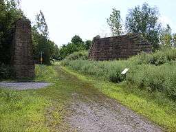
Intersection of the Greenway with the Lehigh Valley Trail, as marked by the white plaque seen on the right. | |
| Length | 90 mi (145 km) |
| Location | New York, United States |
| Trailheads |
Rochester, New York Cuba, New York |
| Use | Hiking, cycling, horseback riding, and cross-country skiing |
| Hiking details | |
| Season | All year |
| Sights | Letchworth State Park |
| Right of way | Pennsylvania Railroad, Genesee Valley Canal |
The Genesee Valley Greenway is a rail trail in western New York's Genesee River valley.
The trail stretches for 90 miles (140 km) along a former Pennsylvania Railroad right-of-way as well as adjacent land from the Genesee Valley Canal. The low grade path is a multi-use trail which is well suited for hiking, biking, horsebacking riding and cross-country skiing.[1]
The Greenway is administered by the New York State Office of Parks, Recreation and Historic Preservation and the Friends of the Genesee Valley Greenway. The New York State Department of Environmental Conservation was a partner in the Greenway's management prior to transferring jurisdiction of their lands to NYSOPRHP in 2010.[2] The project began in 1991 as a way to reuse mostly abandoned land from the old railways. Construction and renovation of land for the trail was underway in 1998.[3]
The Genesee Valley Greenway intersects with the Erie Canal Heritage Trail south of the city of Rochester at the Genesee Valley Park, thereby forming part of a network of green corridors for hikers and cyclists stretching across New York State. As of 2016, the Greenway passes through Monroe, Livingston, Wyoming and Allegany counties, connecting the City of Rochester and the Village of Cuba, with plans to eventually extend the trail to Hinsdale in Cattaraugus County.[1]
Trail conditions
Because the northern portions of the Greenway are converted railroad track bed, it is relatively smooth, straight, and level. Portions of the trail near to, and south of, Letchworth State Park are very hilly and strenuous.
Where the trail crosses highways and waterways, many of the structures used to support the previous railway are either reused, or new prefabricated bridges have been placed on old bridge abutments.
Roads that cross the Greenway fall in two general categories:
- Roads constructed while the railway or Greenway was in operation
- These intersections typically have the road on an even grade with the Greenway or (for larger highways) a bridge where one crosses the other
- Greenway patrons simply need to avoid cars in crossing the road (if no bridge is present)
- Roads constructed while the railway was abandoned
- These intersections may be quite awkward to cross because of differences in elevation between the roadway and the Greenway
- The Greenway may have steep inclines or switchbacks to quickly change elevation to match the roadway
Places of historic interest
Because of the historic nature of much of the land that the Greenway traverses, points of interest along the trail are marked by plaques with descriptions of the significance of the site, along with historic photographs and maps.
Among the marked sites are:
- Abandoned Genesee Valley Canal locks
- Old railway bridges and bridge abutments
- Sites important to the Pennsylvania Railroad that previously occupied the land
- Erie-Lackawanna Railroad bridge over the Genesee River[4]
References
- 1 2 "Genesee Valley Greenway State Park". NYS Office of Parks, Recreation & Historic Preservation. Retrieved February 14, 2016.
- ↑ "Genesee Valley Greenway State Park Management Plan - Introduction" (PDF). NYS Office of Parks, Recreation & Historic Preservation. December 30, 2013. Retrieved February 15, 2016.
- ↑ "Appendix K: History of the Genesee Valley Greenway State Park". Genesee Valley Greenway State Park Management Plan - Appendices (PDF). NYS Office of Parks, Recreation & Historic Preservation. December 30, 2013. Retrieved February 15, 2016.
- ↑ "Erie-Lackawanna Rails-to-Trails Pedestrian Bridge". City of Rochester. Retrieved February 14, 2016.
External links
- New York State Parks: Genesee Valley Greenway State Park
- Genesee Valley Greenway map
- Friends of Genesee Valley Greenway website contains information about the Greenway and maps of it.
- Rails-to-Trails Conservancy's page on the Genesee Valley Greenway
| Albany |
|    |
|---|---|---|
| Allegany | ||
| Cattaraugus | ||
| Cayuga | ||
| Columbia | ||
| Delaware | ||
| Dutchess | ||
| Franklin | ||
| Livingston | ||
| Monroe |
| |
| New York | ||
| Ontario | ||
| Orange | ||
| Oswego | ||
| Putnam | ||
| Rockland |
| |
| St. Lawrence | ||
| Schenectady | ||
| Ulster | ||
| Westchester | ||
| Wyoming | ||