North Country Trail
| North Country Trail | |
|---|---|
|
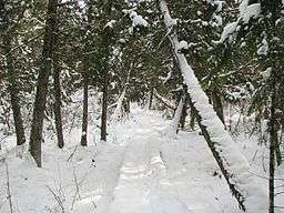
A segment of the North Country Trail passing through the Brule Bog in Wisconsin's Brule River State Forest | |
| Length | 4600 mi (7403 km) |
| Location | New York / Pennsylvania / Ohio / Michigan / Wisconsin / Minnesota / North Dakota |
| Designation | National Scenic Trail (1980) |
| Trailheads |
Lake Sakakawea State Park, North Dakota Crown Point State Historic Site, New York |
| Use | Hiking |
| Hiking details | |
| Trail difficulty | Easy to strenuous |
| Sights | Diverse environmental features of the northern and midwestern United States |
The North Country National Scenic Trail, generally known as the North Country Trail or simply the N.C.T., is a footpath stretching approximately 4,600 miles (7,400 km) from Crown Point in eastern New York to Lake Sakakawea State Park in central North Dakota in the United States. Passing through the seven states of New York, Pennsylvania, Ohio, Michigan, Wisconsin, Minnesota, and North Dakota, it is the longest of the eleven National Scenic Trails authorized by Congress. Like its sister trails, it was designed to provide outdoor recreational opportunities in some of the America's outstanding landscapes. As of early 2014, 2,730 miles (4,390 km) have been completed.
The NCT is administered by the National Park Service, managed by federal, state, and local agencies, and built and maintained primarily by the volunteers of the North Country Trail Association (NCTA) and its partners. The 28 chapters of the NCTA, its 3,200+ members and each affiliate organization have assumed responsibility for trail construction and maintenance of a specific section of the NCT.
Route
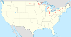
The trail begins in northeast New York and proceeds to the western end of the state. It cuts across northwestern Pennsylvania, then follows a southwesterly course through the hilly region of southern Ohio until it nears Cincinnati when it runs north through western Ohio to the hills of SE Michigan. It continues from southeast Michigan through the western Lower Peninsula, crosses the Straits of Mackinac, and takes a northern route the length of the Upper Peninsula. After crossing northern Wisconsin, one leg follows the Lake Superior shore to the northeast corner of Minnesota before turning west, where it meets the other leg in central northern Minnesota. The trail enters southeast North Dakota, and continues to its other terminus in the center of the state.
The NCT connects more than 160 public land units, including parks, forests, scenic attractions, wildlife refuges, game areas, and historic sites. The list includes:
- Ten National Forest areas (Finger Lakes in New York; Allegheny in Pennsylvania; Wayne in Ohio; Manistee, Hiawatha, and Ottawa in Michigan; Chequamegon in Wisconsin; Superior and Chippewa in Minnesota; and Sheyenne National Grassland in North Dakota)
- Four areas of the National Park Service (Michigan's Pictured Rocks National Lakeshore, Wisconsin's St. Croix National Scenic Riverway, New York's Fort Stanwix National Monument, and Ohio's Dayton Aviation Heritage National Historical Park)
Other federal facilities along the NCT include:
- Two National Wildlife Refuges (Minnesota's Tamarac and North Dakota's Audubon)
- Two Bureau of Reclamation projects (North Dakota's Garrison Diversion Unit's New Rockford and McCluskey Canals) and,
- Six Army Corps of Engineers impoundments (Baldhill Dam at Lake Ashtabula, North Dakota, Tom Jenkins Dam and Burr Oak Lake, William H. Harsha Lake [also known as East Fork Lake], Ohio, Tionesta Lake, the Kinzua Dam, and Allegheny Reservoir, Pennsylvania)
The NCT also threads its way through 57 state parks and state historic areas, 47 state forests, 22 state game areas, seven state water conservation districts and at least ten county forests and parks. Several hundred miles of trail eventually will also cross private land thanks to owners who have granted easements across their property.
The center point of the trail is located near the NCTA headquarters in Lowell, Michigan.
Though the eastern terminus of the North Country Trail is only a few miles from Vermont's Long Trail and the Appalachian Trail, there is not yet a connecting trail to either of those trail systems. Efforts are under way to connect to the Appalachian Trail.[1]
History
When the Trail was established in 1980, portions of it were designed to follow the already existing Finger Lakes (New York), Baker (Pennsylvania), and Buckeye (Ohio) Trails. Their sponsoring organizations became affiliates of the North Country Trail Association and agreed to maintain those portions of their trails to be used by the North Country National Scenic Trail. The Northwestern Ohio Rails-to-Trails Association joined later to help create a link between the Buckeye Trail in Ohio and newly constructed trail in Michigan; the Superior Hiking Trail Association and the Kekekabic Trail Club joined when it was proposed that the North Country National Scenic Trail route through Minnesota be changed to include an already-completed section of the Superior Hiking Trail along Lake Superior, and the Kekekabic and Border Route Trails along the Canada–US border in Minnesota's Arrowhead Region.
Trail progress by state
Ohio

Use
Existing and new sections of the NCT are generally limited to foot travel, including hiking, snowshoeing and cross-country skiing. Other non-motorized uses, such as bicycling and horseback riding are generally limited to areas specifically designed to withstand such use.
About 10,000 people are involved with the NCT in one way or another, either through membership in the North Country Trail Association or membership in one of eight organizations affiliated with the NCTA: the Finger Lakes Trail Conference, the Buckeye Trail Association, the Superior Hiking Trail Association, the Kekekabic Trail Club, the Northwestern Ohio Rails-to-Trails Association, the Butler Outdoor Club, the Rachael Carson Trails Conservancy and the Friends of the Jordan River National Fish Hatchery.
Gallery
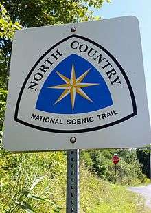
 A trail post that includes the trail's official logo
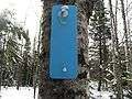 Blue blazes, where allowed, mark the path of the North Country Trail
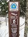
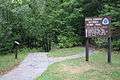 Sign in Wisconsin
See also
References
- ↑ Associated Press (25 June 2012). "Efforts under way to link Appalachian Trail with 4,600-mile trail to ND, nation's longest". Washington Post. Retrieved 25 June 2012.
- ↑ "Welcome to Wabash Cannonball Trail". Retrieved 3 April 2016.
- ↑ "National Park Service, North Country Trail". Retrieved 3 April 2016.
External links
| Wikimedia Commons has media related to North Country Trail. |
- North Country Trail Association
- The North Country Trail on the National Park Service's website
- Journals from the North Country Trail
- North Country Trail Video produced by Wisconsin Public Television