Maysville, Arkansas
| Maysville, Arkansas | |
|---|---|
| Census-designated place | |
|
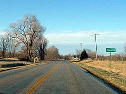
Maysville southern limits, February 2013 | |
 Maysville, Arkansas | |
| Coordinates: 36°24′13″N 94°36′07″W / 36.40361°N 94.60194°W | |
| Country | United States |
| State | Arkansas |
| County | Benton |
| Area[1] | |
| • Total | 2.335 sq mi (6.05 km2) |
| • Land | 2.335 sq mi (6.05 km2) |
| • Water | 0 sq mi (0 km2) |
| Elevation | 1,043 ft (318 m) |
| Population (2010)[2] | |
| • Total | 130 |
| • Density | 56/sq mi (21/km2) |
| Time zone | Central (CST) (UTC-6) |
| • Summer (DST) | CDT (UTC-5) |
| Area code(s) | 479 |
| GNIS feature ID | 77622[3] |
Maysville is an unincorporated community in Benton County, Arkansas, United States. It is the westernmost settlement in the state of Arkansas.[4] As of the 2010 census, its population is 130.[2] It is the location of (or is the nearest community to) Coats School, which is located on Spavinaw Creek Rd. and Sellers Farm, which is located on Old Hwy. on State Line. Both are listed on the National Register of Historic Places.[5]
References
- ↑ "US Gazetteer files: 2010, 2000, and 1990". United States Census Bureau. 2011-02-12. Retrieved 2011-04-23.
- 1 2 "American FactFinder". U.S. Census Bureau. Retrieved 6 May 2011.
- ↑ U.S. Geological Survey Geographic Names Information System: Maysville, Arkansas
- ↑ "EXTREME SETTLEMENTS: A COMPREHENSIVE LIST". Weekend Roady. 2013-05-02. Retrieved 2014-08-20.
- ↑ National Park Service (2009-03-13). "National Register Information System". National Register of Historic Places. National Park Service.
Municipalities and communities of Benton County, Arkansas, United States | ||
|---|---|---|
| Cities | 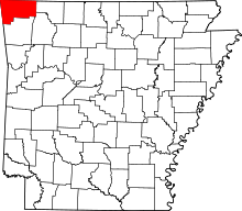 | |
| Towns | ||
| Townships | ||
| CDPs | ||
| Other communities |
| |
| Ghost town | ||
| Footnotes | ‡This populated place also has portions in an adjacent county or counties | |
Coordinates: 36°24′13″N 94°36′07″W / 36.40361°N 94.60194°W
This article is issued from Wikipedia - version of the 6/17/2015. The text is available under the Creative Commons Attribution/Share Alike but additional terms may apply for the media files.