Gateway, Arkansas
| Gateway, Arkansas | |
|---|---|
| Town | |
|
Principal intersection in Gateway, Arkansas | |
 Location in Benton County and the state of Arkansas | |
| Coordinates: 36°29′10″N 93°56′18″W / 36.48611°N 93.93833°WCoordinates: 36°29′10″N 93°56′18″W / 36.48611°N 93.93833°W | |
| Country | United States |
| State | Arkansas |
| County | Benton |
| Area | |
| • Total | 6.1 sq mi (15.9 km2) |
| • Land | 6.1 sq mi (15.9 km2) |
| • Water | 0 sq mi (0 km2) |
| Elevation | 1,535 ft (468 m) |
| Population (2010) | |
| • Total | 405 |
| • Density | 66/sq mi (25.5/km2) |
| Time zone | Central (CST) (UTC-6) |
| • Summer (DST) | CDT (UTC-5) |
| ZIP code | 72733 |
| Area code(s) | 479 |
| FIPS code | 05-26110 |
| GNIS feature ID | 0057802 |

Gateway is a town in Benton County, Arkansas, United States. The population was 405 at the 2010 census,[1] up from 116 at the 2000 census. It is part of the Fayetteville–Springdale–Rogers, AR-MO Metropolitan Statistical Area. The town's name reflects its situation as the "gateway" to and from Arkansas.
Geography
Gateway is located in northeastern Benton County at 36°29′10″N 93°56′18″W / 36.48611°N 93.93833°W (36.486000, -93.938253),[2] along the Missouri border. U.S. Route 62 passes through the town, leading east to Eureka Springs and Berryville and southwest to Rogers. Arkansas Highway 37 leads north to the Missouri line, where Missouri Route 37 continues north to Seligman and Cassville, Missouri. Gateway is on a plateau in the Ozarks at 1,600 feet (490 m) above sea level, overlooking the valley of the White River and Beaver Lake to the south.
According to the United States Census Bureau, the town has a total area of 6.1 square miles (15.9 km2), all of it land.[1]
Demographics
| Historical population | |||
|---|---|---|---|
| Census | Pop. | %± | |
| 1940 | 57 | — | |
| 1950 | 97 | 70.2% | |
| 1960 | 63 | −35.1% | |
| 1970 | 83 | 31.7% | |
| 1980 | 75 | −9.6% | |
| 1990 | 65 | −13.3% | |
| 2000 | 116 | 78.5% | |
| 2010 | 405 | 249.1% | |
| Est. 2015 | 425 | [3] | 4.9% |
2014 Estimate[5] | |||
As of the census[6] of 2000, there were 116 people, 43 households, and 30 families residing in the town. The population density was 203.9 people per square mile (78.6/km²). There were 48 housing units at an average density of 84.4/sq mi (32.5/km²). The racial makeup of the town was 96.55% White and 3.45% Native American.
There were 43 households out of which 39.5% had children under the age of 18 living with them, 62.8% were married couples living together, 2.3% had a female householder with no husband present, and 30.2% were non-families. 20.9% of all households were made up of individuals and 7.0% had someone living alone who was 65 years of age or older. The average household size was 2.70 and the average family size was 3.27.
In the town the population was spread out with 26.7% under the age of 18, 12.1% from 18 to 24, 25.9% from 25 to 44, 28.4% from 45 to 64, and 6.9% who were 65 years of age or older. The median age was 38 years. For every 100 females there were 107.1 males. For every 100 females age 18 and over, there were 117.9 males.
The median income for a household in the town was $32,679, and the median income for a family was $45,625. Males had a median income of $41,875 versus $33,958 for females. The per capita income for the town was $16,557. There were 9.1% of families and 10.1% of the population living below the poverty line, including none under 18 and 50.0% of those over 65.
Education
Public education for early childhood, elementary, and secondary school students is provided by the Rogers and Pea Ridge School District.
References
- 1 2 "Geographic Identifiers: 2010 Demographic Profile Data (G001): Gateway town, Arkansas". U.S. Census Bureau, American Factfinder. Retrieved September 24, 2013.
- ↑ "US Gazetteer files: 2010, 2000, and 1990". United States Census Bureau. 2011-02-12. Retrieved 2011-04-23.
- ↑ "Annual Estimates of the Resident Population for Incorporated Places: April 1, 2010 to July 1, 2015". Retrieved July 2, 2016.
- ↑ "Census of Population and Housing". Census.gov. Retrieved June 4, 2015.
- ↑ "Annual Estimates of the Resident Population for Incorporated Places: April 1, 2010 to July 1, 2014". Retrieved June 4, 2015.
- ↑ "American FactFinder". United States Census Bureau. Retrieved 2008-01-31.
Municipalities and communities of Benton County, Arkansas, United States | ||
|---|---|---|
| Cities | 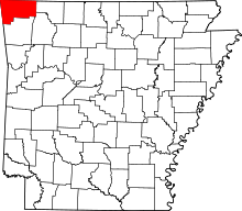 | |
| Towns | ||
| Townships | ||
| CDPs | ||
| Other communities |
| |
| Ghost town | ||
| Footnotes | ‡This populated place also has portions in an adjacent county or counties | |