Highfill, Arkansas
| Highfill, Arkansas | |
|---|---|
| Town | |
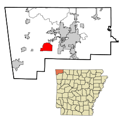 Location in Benton County and the state of Arkansas | |
| Coordinates: 36°16′14″N 94°19′30″W / 36.27056°N 94.32500°WCoordinates: 36°16′14″N 94°19′30″W / 36.27056°N 94.32500°W | |
| Country | United States |
| State | Arkansas |
| County | Benton |
| Area | |
| • Total | 18.3 sq mi (47.3 km2) |
| • Land | 18.2 sq mi (47.1 km2) |
| • Water | 0.1 sq mi (0.3 km2) |
| Elevation | 1,352 ft (412 m) |
| Population (2010) | |
| • Total | 583 |
| • Density | 32/sq mi (12.4/km2) |
| Time zone | Central (CST) (UTC-6) |
| • Summer (DST) | CDT (UTC-5) |
| FIPS code | 05-32200 |
| GNIS feature ID | 0057923 |
| Website |
myhighfill |
Highfill is a town in Benton County, Arkansas, United States. The population was 583 at the 2010 census.[1] It is home to the Northwest Arkansas Regional Airport, which serves all of Northwest Arkansas, including the Bentonville–Fayetteville–Siloam Springs–Springdale–Rogers, AR-MO-OK Metropolitan Statistical Area.
Geography
Highfill is located in west-central Benton County at 36°16′14″N 94°19′30″W / 36.27056°N 94.32500°W (36.270483, -94.325093).[2] Arkansas Highway 12 passes through the town, leading northeast to Bentonville and Rogers and west to Gentry. The Northwest Arkansas Regional Airport occupies the eastern part of town.
According to the United States Census Bureau, Highfill has a total area of 18.3 square miles (47.3 km2), of which 18.2 square miles (47.1 km2) is land and 0.12 square miles (0.3 km2), or 0.58%, is water.[1]
Demographics
| Historical population | |||
|---|---|---|---|
| Census | Pop. | %± | |
| 1960 | 92 | — | |
| 1970 | 80 | −13.0% | |
| 1980 | 92 | 15.0% | |
| 1990 | 84 | −8.7% | |
| 2000 | 379 | 351.2% | |
| 2010 | 583 | 53.8% | |
| Est. 2015 | 632 | [3] | 8.4% |
As of the census[5] of 2010, there were 561 people, 191 households, and 153 families residing in the town. The population density was 12.9/km² (33.5/mi²). There were 165 housing units at an average density of 5.6/km² (14.6/mi²). The racial makeup of the town was 92.08% White, 5.28% Native American, 1.06% Asian, 1.32% from other races, and 0.26% from two or more races. 1.06% of the population were Hispanic or Latino of any race.
There were 144 households out of which 32.6% had children under the age of 18 living with them, 61.1% were married couples living together, 11.8% had a female householder with no husband present, and 22.9% were non-families. 19.4% of all households were made up of individuals and 6.9% had someone living alone who was 65 years of age or older. The average household size was 2.63 and the average family size was 2.90.
In the town the population was spread out with 26.4% under the age of 18, 8.4% from 18 to 24, 31.4% from 25 to 44, 22.7% from 45 to 64, and 11.1% who were 65 years of age or older. The median age was 34 years. For every 100 females there were 100.5 males. For every 100 females age 18 and over, there were 95.1 males.
The median income for a household in the town was $28,854, and the median income for a family was $30,938. Males had a median income of $21,477 versus $21,705 for females. The per capita income for the town was $12,701. About 5.3% of families and 18.6% of the population were below the poverty line, including 21.4% of those under age 18 and 29.2% of those age 65 or over.
Education
Public education is available from two school districts based on resident's location:
- Gentry School District that leads to graduation from Gentry High School.
- Bentonville School District that leads to graduation from Bentonville High School.
References
- 1 2 "Geographic Identifiers: 2010 Demographic Profile Data (G001): Highfill town, Arkansas". U.S. Census Bureau, American Factfinder. Retrieved September 24, 2013.
- ↑ "US Gazetteer files: 2010, 2000, and 1990". United States Census Bureau. 2011-02-12. Retrieved 2011-04-23.
- ↑ "Annual Estimates of the Resident Population for Incorporated Places: April 1, 2010 to July 1, 2015". Retrieved July 2, 2016.
- ↑ "Census of Population and Housing". Census.gov. Retrieved June 4, 2015.
- ↑ "American FactFinder". United States Census Bureau. Retrieved 2008-01-31.
External links
Municipalities and communities of Benton County, Arkansas, United States | ||
|---|---|---|
| Cities | 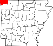 | |
| Towns | ||
| Townships | ||
| CDPs | ||
| Other communities |
| |
| Ghost town | ||
| Footnotes | ‡This populated place also has portions in an adjacent county or counties | |