Mare Tyrrhenum quadrangle
|
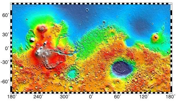
Map of Mare Tyrrhenum quadrangle from Mars Orbiter Laser Altimeter (MOLA) data. The highest elevations are red and the lowest are blue. | |
| Coordinates | 15°00′S 247°30′W / 15°S 247.5°WCoordinates: 15°00′S 247°30′W / 15°S 247.5°W |
|---|---|


The Mare Tyrrhenum quadrangle is one of a series of 30 quadrangle maps of Mars used by the United States Geological Survey (USGS) Astrogeology Research Program. The Mare Tyrrhenum quadrangle is also referred to as MC-22 (Mars Chart-22).[1] The Mare Tyrrhenum quadrangle contains parts of the regions Tyrrhena Terra, Hesperia Planum, and Terra Cimmeria.
The Mare Tyrrhenum quadrangle covers the area from 225° to 270° west longitude and 0° to 30° south latitude on Mars. Schiaparelli named the area after Earth's Tyrrhenian Sea, which lies between Italy and Sicily. The region was subsequently renamed to Mare Tyrrhena after spacecraft photos revealed that it is an old, cratered plain rather than a sea. It contains the large volcano Tyrrhenus Mons, one of the oldest, and perhaps the most complex volcanoes on Mars.[2][3] Mare Tyrrhenum's largest crater is Herschel. Licus Vallis and the Ausonia Montes are other major features in the region.
Fossa on Mars
Large troughs (long narrow depressions) are called fossae in the geographical language used for Mars. Troughs form when the crust is stretched until it breaks. The stretching can be due to the large weight of a nearby volcano. Fossae/pit craters are common near volcanoes in the Tharsis and Elysium system of volcanoes.[4] A trough often has two breaks with a middle section moving down, leaving steep cliffs along the sides; such a trough is called a graben.[5] Lake George, in northern New York State, is a lake that sits in a graben. Studies have found that on Mars a fault may be as deep as 5 km, that is the break in the rock goes down to 5 km. Moreover, the crack or fault sometimes widens or dilates. This widening causes a void to form with a relatively high volume. When material slides into the void, a pit crater or a pit crater chain forms. Pit craters do not have rims or ejecta around them, like impact craters do. On Mars, individual pit craters can join to form chains or even to form troughs that are sometimes scalloped.[6] Other ideas have been suggested for the formation of fossae and pit craters. There is evidence that they are associated with dikes of magma. Magma might move along, under the surface, breaking the rock and more importantly melting ice. The resulting action would cause a crack to form at the surface. Pit craters are not common on Earth. Sinkholes, where the ground falls into a hole (sometimes in the middle of a town) resemble pit craters on Mars. However, on the Earth these holes are caused by limestone being dissolved thereby causing a void.[6][7][8] Tyrrhenus Mons has some beautiful fossae and pit craters associated with it. These features are easily visible in the gallery image below, obtained by HiRISE.
Knowledge of the locations and formation mechanisms of pit craters and fossae is important for the future colonization of Mars because they may be reservoirs of water.[9]
Craters
- Herschel Herschel (Martian crater)
- Kinkora Kinkora (crater)
- Müller Müller (Martian crater)
- Robert Shart Robert Sharp (crater)
- Resen Resen (Martian crater)
- Kinkora Kinkora Crater
- Briault Briault Crater
Why are Craters important?
The density of impact craters is used to determine the surface ages of Mars and other solar system bodies.[10] The older the surface, the more craters present. Crater shapes can reveal the presence of ground ice.
The area around craters may be rich in minerals. On Mars, heat from the impact melts ice in the ground. Water from the melting ice dissolves minerals, and then deposits them in cracks or faults that were produced with the impact. This process, called hydrothermal alteration, is a major way in which ore deposits are produced. The area around Martian craters may be rich in useful ores for the future colonization of Mars.[11]
 Depression on crater floor, as seen by HiRISE under HiWish program. This scene is enlarged in the next two images.
 Close-up of depression on crater floor, as seen by HiRISE under HiWish program.
 Close-up of west edge of crater depression, as seen by HiRISE under HiWish program.
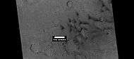
 Dunes in crater, as seen by HiRISE under HiWish program. Some of these dunes are Barchans.
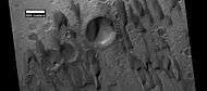 Dunes among craters, as seen by HiRISE under HiWish program. Some of these dunes are Barchans. Research published in Icarus stated that the dunes in Hershel Crater moved 0.8 m in a time span of 3.7 Earth-years. Also, it was determined that dune ripple moved 1.1 m in that time period. Other dunes may exhibit a similar amount of movement.[12]
Hydrothermal features in Auki Crater
Auki Crater shows ridge networks that are believed to be evidence of hydrothermal processes that occurred after impact. Impacts fracture rock and create enormous amounts of heat. On Mars, this heat can cause ice to melt and then the resulting water to move through cracks that are generated during impact. This water will eventually deposit minerals. The mineral deposits may become evident when surrounding ground erodes. Deposits formed in this manner are more resistant to erosion.
Researchers have speculated that these hydrothermal effects should be common on Mars.[13] Ridges found in and around the center of Auki Crater are evidence. This crater contains ridges that may have been produced after fractures formed with an impact. Using instruments on the Mars Reconnaissance Orbiter they found the minerals smectite, silica, zeolite, serpentine, carbonate, and chorite that are common in impact-induced hydrothermal systems on Earth.[14] [15] [16] [17] [18] [19] Other evidence of post-impact hydrothermal systems on Mars from other scientists who studied other Martian craters.[20] [21] [22]
 Topographical map showing location of Auki Crater and other nearby features. Color shows elevation.
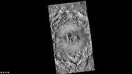 Wide view of Auki Crater, as seen by CTX
 Close view of central portion of Auki Crater, as seen by HiRISE Arrow indicates ridges. Sand dunes are present near the top of the image.
 Close view of ridges from previous HiRISE image Arrow indicates an "X" shaped ridge.
 Close view of central section of Auki Crater showing ridges with arrow Image is an enlargement of a previous HiRISE image.
Channels
There is enormous evidence that water once flowed in river valleys and channels on Mars. Images of curved channels have been seen in images from Mars spacecraft dating back to the early seventies with the Mariner 9 orbiter.[23][24][25][26] Vallis (plural valles) is the Latin word for valley. It is used in planetary geology for the naming of landform features on other planets, including what could be old river valleys that were discovered on Mars, when probes were first sent to Mars. The Viking Orbiters caused a revolution in our ideas about water on Mars; huge river valleys were found in many areas. Space craft cameras showed that floods of water broke through dams, carved deep valleys, eroded grooves into bedrock, and traveled thousands of kilometers.[27][28][29] Some valles on Mars (Mangala Vallis, Athabasca Vallis, Granicus Vallis, and Tinjar Valles) clearly begin at graben. On the other hand, some of the large outflow channels begin in rubble-filled low areas called chaos or chaotic terrain. It has been suggested that massive amounts of water were trapped under pressure beneath a thick cryosphere (layer of frozen ground), then the water was suddenly released, perhaps when the cryosphere was broken by a fault.[30][31]
 Small meandering channel in the stream bed of a larger channel. Water probably eroded the two channels at different times. Image from HiRISE under the HiWish program.
 Channel in Ausonia Mensa, as seen by HiRISE under the HiWish program.
 Licus Vallis, as seen by HiRISE
 Channel, as seen by HiRISE under the HiWish program.
Linear ridge networks
Linear ridge networks are found in various places on Mars in and around craters.[32] Ridges often appear as mostly straight segments that intersect in a lattice-like manner. They are hundreds of meters long, tens of meters high, and several meters wide. It is thought that impacts created fractures in the surface, these fractures later acted as channels for fluids. Fluids cemented the structures. With the passage of time, surrounding material was eroded away, thereby leaving hard ridges behind. Since the ridges occur in locations with clay, these formations could serve as a marker for clay which requires water for its formation. [33] [34] [35] Water here could have supported past life in these locations. Clay may also preserve fossils or other traces of past life.
 Linear ridge network, as seen by HiRISE under HiWish program
 Wide view of several groups of linear ridges, as seen by HiRISE under HiWish program
 Close view of curved ridges, as seen by HiRISE under HiWish program Note: this is an enlargement of previous image.
 Close view of ridges, from a previous image, as seen by HiRISE under HiWish program
 Close view of ridges, from a previous image, as seen by HiRISE under HiWish program Arrows indicate fractures in ridge
 Blocks probably formed after fracturing in ridges Image, as seen by HiRISE under HiWish program
 Wide view of ridge networks, as seen by HiRISE under HiWish program Parts of this are enlarged in next three images.
 Close view of ridge networks, as seen by HiRISE under HiWish program
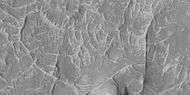 Close view of ridge networks, as seen by HiRISE under HiWish program
 Close view of ridge networks, as seen by HiRISE under HiWish program Since some ridges are at the bottom of the depression, the ridges may be from a lower layer.
Dunes
 Dunes, as seen by HiRISE under HiWish program
 Close view of dunes, as seen by HiRISE under HiWish program
 Close, color view of dunes as seen by HiRISE under HiWish program Ripples are visible on dune surface.
Other views in Mare Tyrrhenum quadrangle
 Map of Mare Tyrrhenum quadrangle. Tyrrhenus Mons is a major volcano.
 The Ausonia Montes in Mare Tyrrhenum as seen by CTX.
 Tyrrhenus Mons, as seen by HiRISE and suggested by Ehsan Sanaei's high school astronomy club in Yazd, Iran. Click on image to see excellent view of pit crater chains and concentric features around a volcano.
 Wide view of ridges that are mostly curved. Picture taken with HiRISE under HiWish program
 Mostly curved ridges Picture taken with HiRISE under HiWish program
 Ridges of different sizes, some indicated by arrows are straight. Picture taken with HiRISE under HiWish program
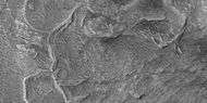 Mostly curved ridges Picture taken with HiRISE under HiWish program
 Ridges, some of which seem to have layers Picture taken with HiRISE under HiWish program
Other Mars quadrangles
Interactive Mars map
See also
References
- ↑ Davies, M.E.; Batson, R.M.; Wu, S.S.C. “Geodesy and Cartography” in Kieffer, H.H.; Jakosky, B.M.; Snyder, C.W.; Matthews, M.S., Eds. Mars. University of Arizona Press: Tucson, 1992.
- ↑ Hartmann, W. 2003. A Traveler's Guide to Mars. Workman Publishing. NY NY.
- ↑ Michael H. Carr (2006). The surface of Mars. Cambridge University Press. ISBN 978-0-521-87201-0. Retrieved 21 March 2011.
- ↑ Skinner, J., L. Skinner, and J. Kargel. 2007. Re-assessment of Hydrovolcanism-based Resurfacing within the Galaxias Fossae Region of Mars. Lunar and Planetary Science XXXVIII (2007)
- ↑ http://hirise.lpl.arizona.edu/PSP_008641_2105
- 1 2 Wyrick, D., D. Ferrill, D. Sims, and S. Colton. 2003. Distribution, Morphology and Structural Associations of Martian Pit Crater Chains. Lunar and Planetary Science XXXIV (2003)
- ↑ http://www.swri.edu/4org/d20/DEMPS/planetgeo/planetmars.html
- ↑ http://www.msss.com/mars_images/moc/2004/01/29/index.html
- ↑ Ferrill, D., D. Wyrick, A. Morris, D. Sims, and N. Franklin. 2004. Dilational fault slip and pit chain formation on Mars 14:10:4-12
- ↑ http://www.lpi.usra.edu/publications/slidesets/stones/
- ↑ http://www.indiana.edu/~sierra/papers/2003/Patterson.html.
- ↑ Cardinale, M., S. Silvestro, D. Vazd, T. Michaels, M. Bourke, G. Komatsu, L. Marinangeli. 2016. Present-day aeolian activity in Herschel Crater, Mars. Icarus: 265, 139-148.
- ↑ Osinski, G., et al. 2013. Impact-generated hydrothermal systems on Earth and Mars. Icarus: 224, 347-363.
- ↑ Carrozzo, F. et al. 2017. Geology and mineralogy of the Auki Crater, Tyrrhena Terra, Mars: A possible post impact-induced hydrothermal system. 281: 228-239
- ↑ Loizeau, D. et al. 2012. Characterization of hydrated silicate-bearing outcrops in tyrrhena Terra, Mars: implications to the alteration history of Mars. Icarus: 219, 476-497.
- ↑ Naumov, M. 2005. Principal features of impact-generated hydrothermal circulation systems: mineralogical and geochemical evidence. Geofluids: 5, 165-184.
- ↑ Ehlmann, B., et al. 2011. Evidence for low-grade metamorphism, hydrothermal alteration, and diagenesis on Mars from phyllosilicate mineral assemblages. Clays Clay Miner: 59, 359-377.
- ↑ Osinski, G. et al. 2013. Impact-generated hydrothermal systems on Earth and Mars. Icarus: 224, 347-363.
- ↑ Schwenzer, S., D. Kring. 2013. Alteration minerals in impact-generated hydrothermal systems – Exploring host rock variability. Icarus: 226, 487-496.
- ↑ Marzo, G., et al. 2010. Evidence for hesperian impact-induced hydrothermalism on Mars. Icarus: 667-683.
- ↑ Mangold, N., et al. 2012. Hydrothermal alteration in a late hesperian impact crater on Mars. 43th Lunar and Planetary Science. #1209.
- ↑ Tornabene, L., et al. 2009. Parautochthonous megabreccias and possible evidence of impact-induced hydrothermal alteration in holden crater, Mars. 40th LPSC. #1766.
- ↑ Baker, V. 1982. The Channels of Mars. Univ. of Tex. Press, Austin, TX
- ↑ Baker, V., R. Strom, R., V. Gulick, J. Kargel, G. Komatsu, V. Kale. 1991. Ancient oceans, ice sheets and the hydrological cycle on Mars. Nature 352, 589–594.
- ↑ Carr, M. 1979. Formation of Martian flood features by release of water from confined aquifers. J. Geophys. Res. 84, 2995–300.
- ↑ Komar, P. 1979. Comparisons of the hydraulics of water flows in Martian outflow channels with flows of similar scale on Earth. Icarus 37, 156–181.
- ↑ Hugh H. Kieffer (1992). Mars. University of Arizona Press. ISBN 978-0-8165-1257-7. Retrieved 7 March 2011.
- ↑ Raeburn, P. 1998. Uncovering the Secrets of the Red Planet Mars. National Geographic Society. Washington D.C.
- ↑ Moore, P. et al. 1990. The Atlas of the Solar System. Mitchell Beazley Publishers NY, NY.
- ↑ Carr, M. 1979. Formation of martian flood features by release of water from confined aquifers. J. Geophys. Res. 84: 2995-3007.
- ↑ Hanna, J. and R. Phillips. 2005. Tectonic pressurization of aquifers in the formation of Mangala and Athabasca Valles on Mars. LPSC XXXVI. Abstract 2261.
- ↑ Head, J., J. Mustard. 2006. Breccia dikes and crater-related faults in impact craters on Mars: Erosion and exposure on the floor of a crater 75 km in diameter at the dichotomy boundary, Meteorit. Planet Science: 41, 1675-1690.
- ↑ Mangold et al. 2007. Mineralogy of the Nili Fossae region with OMEGA/Mars Express data: 2. Aqueous alteration of the crust. J. Geophys. Res., 112, doi:10.1029/2006JE002835.
- ↑ Mustard et al., 2007. Mineralogy of the Nili Fossae region with OMEGA/Mars Express data: 1. Ancient impact melt in the Isidis Basin and implications for the transition from the Noachian to Hesperian, J. Geophys. Res., 112.
- ↑ Mustard et al., 2009. Composition, Morphology, and Stratigraphy of Noachian Crust around the Isidis Basin, J. Geophys. Res., 114, doi:10.1029/2009JE003349.
- 1 2 Morton, Oliver (2002). Mapping Mars: Science, Imagination, and the Birth of a World. New York: Picador USA. p. 98. ISBN 0-312-24551-3.
- ↑ "Online Atlas of Mars". Ralphaeschliman.com. Retrieved December 16, 2012.
- ↑ "PIA03467: The MGS MOC Wide Angle Map of Mars". Photojournal. NASA / Jet Propulsion Laboratory. February 16, 2002. Retrieved December 16, 2012.
- ↑ "Online Atlas of Mars". Ralphaeschliman.com. Retrieved December 16, 2012.
- ↑ "PIA03467: The MGS MOC Wide Angle Map of Mars". Photojournal. NASA / Jet Propulsion Laboratory. February 16, 2002. Retrieved December 16, 2012.
Further reading
- Lorenz, R. 2014. The Dune Whisperers. The Planetary Report: 34, 1, 8-14
- Lorenz, R., J. Zimbelman. 2014. Dune Worlds: How Windblown Sand Shapes Planetary Landscapes. Springer Praxis Books / Geophysical Sciences.
External links
| Wikimedia Commons has media related to Mare Tyrrhenum quadrangle. |
| Quadrangles on Mars | ||||||||||||||||||||||||||||||||||||||||||||||||||||||||||||||||||||||||||||||||||||||||||||||||||||||||||||||||||||||||||||||||||||||||||||||||
|---|---|---|---|---|---|---|---|---|---|---|---|---|---|---|---|---|---|---|---|---|---|---|---|---|---|---|---|---|---|---|---|---|---|---|---|---|---|---|---|---|---|---|---|---|---|---|---|---|---|---|---|---|---|---|---|---|---|---|---|---|---|---|---|---|---|---|---|---|---|---|---|---|---|---|---|---|---|---|---|---|---|---|---|---|---|---|---|---|---|---|---|---|---|---|---|---|---|---|---|---|---|---|---|---|---|---|---|---|---|---|---|---|---|---|---|---|---|---|---|---|---|---|---|---|---|---|---|---|---|---|---|---|---|---|---|---|---|---|---|---|---|---|---|---|
| ||||||||||||||||||||||||||||||||||||||||||||||||||||||||||||||||||||||||||||||||||||||||||||||||||||||||||||||||||||||||||||||||||||||||||||||||