Noachis quadrangle
|
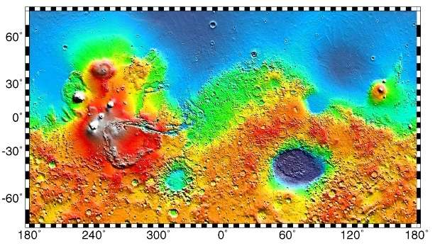
Map of Noachis quadrangle from Mars Orbiter Laser Altimeter (MOLA) data. The highest elevations are red and the lowest are blue. | |
| Coordinates | 47°30′S 330°00′W / 47.5°S 330°WCoordinates: 47°30′S 330°00′W / 47.5°S 330°W |
|---|---|


The Noachis quadrangle is one of a series of 30 quadrangle maps of Mars used by the United States Geological Survey (USGS) Astrogeology Research Program. The Noachis quadrangle is also referred to as MC-27 (Mars Chart-27).[1]
The Noachis quadrangle covers the area from 300° to 360° west longitude and 30° to 65° south latitude on Mars. It lies between the two giant impact basins on Mars: Argyre and Hellas. The Noachis quadrangle includes Noachis Terra and the western part of Hellas Planitia.
Noachis is so densely covered with impact craters that it is considered among the oldest landforms on Mars—hence the term "Noachian" for one of the earliest time periods in martian history. In addition, many previously buried craters are now coming to the surface,[2] where Noachis' extreme age has allowed ancient craters to be filled, and once again newly exposed.
Much of the surface in Noachis quadrangle shows a scalloped topography where the disappearance of ground ice has left depressions.[3][4]
The first piece of human technology to land on Mars landed (crashed) in the Noachis quadrangle. The Soviet's Mars 2 crashed at 44°12′S 313°12′W / 44.2°S 313.2°W. It weighed about one ton. The automated craft attempted to land in a giant dust storm. To make conditions even worse, this area also has many dust devils.[5]
Scalloped topography

Certain regions of Mars display scalloped-shaped depressions. The depressions are believed to be the remains of an ice-rich mantle deposit. Scallops are created when ice sublimates from frozen soil. This mantle material probably fell from the air as ice formed on dust when the climate was different due to changes in the tilt of the Mars pole.[6] The scallops are typically tens of meters deep and from a few hundred to a few thousand meters across. They can be almost circular or elongated. Some appear to have coalesced, thereby causing a large heavily pitted terrain to form. A study published in Icarus, found that the landforms of scalloped topography can be made by the subsurface loss of water ice by sublimation under current Martian climate conditions. Their model predicts similar shapes when the ground has large amounts of pure ice, up to many tens of meters in depth.[7] The process of producing the terrain may begin with sublimation from a crack because there are often polygon cracks where scallops form.[3][4]
Dust Devil Tracks
Many areas on Mars experience the passage of giant dust devils. A thin coating of fine bright dust covers most of the Martian surface. When a dust devil goes by it blows away the coating and exposes the underlying dark surface creating tracks. Dust devils have been seen from the ground and from orbit. They have even blown the dust off of the solar panels of the two Rovers on Mars, thereby greatly extending their lives.[8] The twin Rovers were designed to last for 3 months, instead they have lasted more than six years and are still going after over 8 years. The pattern of the tracks have been shown to change every few months.[9] TA study that combined data from the High Resolution Stereo Camera (HRSC) and the Mars Orbiter Camera (MOC) found that some large dust devils on Mars have a diameter of 700 meters and last at least 26 minutes.[10] The image below of Russel Crater shows changes in dust devil tracks over a period of only three months, as documented by HiRISE. Other Dust Devil Tracks are visible in the picture of Frento Vallis.
 Russell Crater Dust Devil Changes, as seen by HiRISE. Click on image to see changes in dust devil tracks in just 3 months.
 Frento Vallis, as seen by HiRISE. Click on image to see better view of Dust Devil Tracks.
Craters
Impact craters generally have a rim with ejecta around them, in contrast volcanic craters usually do not have a rim or ejecta deposits. As craters get larger (greater than 10 km in diameter) they usually have a central peak.[11] The peak is caused by a rebound of the crater floor following the impact.[12] Sometimes craters will display layers. Craters can show us what lies deep under the surface.
Why are Craters important?
The density of impact craters is used to determine the surface ages of Mars and other solar system bodies.[11] The older the surface, the more craters present. Crater shapes can reveal the presence of ground ice.
The area around craters may be rich in minerals. On Mars, heat from the impact melts ice in the ground. Water from the melting ice dissolves minerals, and then deposits them in cracks or faults that were produced with the impact. This process, called hydrothermal alteration, is a major way in which ore deposits are produced. The area around Martian craters may be rich in useful ores for the future colonization of Mars.[13] Studies on the earth have documented that cracks are produced and that secondary minerals veins are deposited in the cracks.[14][15][16] Images from satellites orbiting Mars have detected cracks near impact craters.[17] Great amounts of heat are produced during impacts. The area around a large impact may take hundreds of thousands of years to cool.[18][19][20] Many craters once contained lakes.[21][22][23] Because some crater floors show deltas, we know that water had to be present for some time. Dozens of deltas have been spotted on Mars.[24] Deltas form when sediment is washed in from a stream entering a quiet body of water. It takes a bit of time to form a delta, so the presence of a delta is exciting; it means water was there for a time, maybe for many years. Primitive organisms may have developed in such lakes; hence, some craters may be prime targets for the search for evidence of life on the Red Planet.[25]
 Maunder Crater, as seen by HiRISE. The overhang is part of the degraded south (toward bottom) wall of crater. The scale bar is 500 meters long.
 Asimov Crater, as seen by HiRISE. Bottom of picture shows southeastern wall of crater. Top of picture is edge of mound that fills most of the crater.
 Layers in west slope of Asimov Crater, as seen by HiRISE.
 Close-up of layers in west slope of Asimov Crater. Shadows show the overhang. Some of the layers are much more resistant to erosion, so they stick out. Image from HiRISE.
 East Slope of Central Pit in Asimov Crater, as seen by HiRISE. Click on image to see more details of the many gullies.
 Kaiser Crater (large crater in upper part of image)context for THEMIS image.
 Detail of south wall of Kaiser Crater, as seen by THEMIS. Top of image shows part of a dune field.
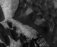 Rabe Crater Floor, as seen by HiRISE. Click on image to see layers. Dark sand that made the dunes was probably blown in from elsewhere.
 Crater that was buried in another age and is now being exposed by erosion, as seen by the Mars Global Surveyor, under the MOC Public Targeting Program.
 Floor of crater in Noachis quadrangle, as seen by HiRISE under HiWish program.
 Erosion forms on floor of crater, as seen by HiRISE under HiWish program
Sand Dunes
When there are perfect conditions for producing sand dunes, steady wind in one direction and just enough sand, a barchan sand dune forms. Barchans have a gentle slope on the wind side and a much steeper slope on the lee side where horns or a notch often forms.[26] One picture below shows a definite barchan.
 Dark dunes (probably basalt), in an intracrater dune field, Noachis. Picture from Mars Global Surveyor, under the MOC Public Targeting Program.
 Wide view of dunes in Noachis, as seen by HiRISE.
 Close-up View of dunes in previous image, as seen by HiRISE. Note how sand barely covers some boulders.
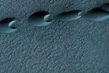 Barchan sand dunes in the Hellespontus region, as seen by HiRISE. The horns point in the downwind direction.
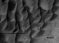 Proctor Crater ripples and dunes, as seen by HiRISE.
 Wide view of a field of sand dunes, as seen by HiRISE under HiWish program
 Close view of sand dunes, as seen by HiRISE under HiWish program A birchen dune is labeled.
 Close view of sand dunes, as seen by HiRISE under HiWish program
 Close view of sand dunes, as seen by HiRISE under HiWish program A birchen dune is labeled.
 Close, color view of sand dunes, as seen by HiRISE under HiWish program
Gullies
Gullies on steep slopes are found in certain regions of Mars. Many ideas have been advanced to explain them. Formation by running water when the climate was different is a popular idea. Recently, because changes in gullies have been seen since HiRISE has been orbiting Mars, it is thought that they may be formed by chunks of dry ice moving down slope during spring time. Gullies are one of the most interesting discoveries made by orbiting space craft.[27][28][29][30]
 Gullies on the wall of a crater, as seen by HiRISE under HiWish program
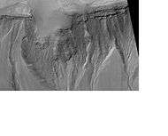 Gullies on mound in Asimov Crater, as seen by HiRISE.
Hellas floor features
The Hellas floor contains some strange-looking features. One of these features is called "banded terrain."[31][32][33] Banded terrain is found in the north-western part of the Hellas basin. This section of the Hellas basin is the deepest. The banded-terrain deposit displays an alternation of narrow band shapes and inter-bands. The sinuous nature and relatively smooth surface texture suggesting a viscous flow origin. A study published in Planetary and Space Science found that this terrain was the youngest deposit of the interior of Hellas. They also suggest in the paper that banded terrain may have covered a larger area of the NW interior of Hellas. The bands can be classified as linear, concentric, or lobate. Bands are typically 3–15 km long, 3 km wide. Narrow inter-band depressions are 65 m wide and 10 m deep.[34] Pictures of these features can look like abstract art.
 Wide view of part of the floor of the Hellas basin, as seen by CTX
 Wide view of Hellas basin floor, as seen by CTX. This is a slight enlargement of the previous image. The box shows the location of the next image that was taken with HiRISE.
 Close-up of banded terrain on the floor of the Hellas basin, as seen by HiRISE Other, previous photos show wide views of this region.
 Twisted Terrain in Hellas Planitia, but actually located in Noachis quadrangle. Imagine trying to walk across this. Image taken with HiRISE.
Other scenes from Noachis quadrangle
 Quadrangle map of Noachis labeled with major features.
 Dissected Mantle with layers, as seen by HiRISE.
 Layers in depression in crater, as seen by HiRISE under HiWish program
 Wide view of ridges, as seen by HiRISE under HiWish program
 Close view of hollows, as seen by HiRISE under HiWish program Note: this is an enlargement of the previous image.
 Ridges, as seen by HiRISE under HiWish program Note: this is an enlargement of the previous image.
Other Mars Quadrangles
Interactive Mars map
See also
References
- ↑ Davies, M.E.; Batson, R.M.; Wu, S.S.C. "Geodesy and Cartography" in Kieffer, H.H.; Jakosky, B.M.; Snyder, C.W.; Matthews, M.S., Eds. Mars. University of Arizona Press: Tucson, 1992.
- ↑ Mars Space Flight Facility (17 March 2004). "Exhumed Crater (Released 17 March 2004)". Arizona State University. Retrieved 19 December 2011.
- 1 2 Lefort, A.; et al. (2010). "Scalloped terrains in the Peneus and Amphitrites Paterae region of Mars as observed by HiRISE". Icarus. 205: 259–268. Bibcode:2010Icar..205..259L. doi:10.1016/j.icarus.2009.06.005.
- 1 2 http://www.sciencedirect.com/science/journal/00191035
- ↑ Hartmann, W. 2003. A Traveler's Guide to Mars. Workman Publishing. NY, NY.
- ↑ Head, J. et al. 2003. Recent ice ages on Mars. Nature:426. 797-802.
- ↑ Dundas, C., S. Bryrne, A. McEwen. 2015. Modeling the development of martian sublimation thermokarst landforms. Icarus: 262, 154-169.
- ↑ "Press Release Images: Spirit". National Aeronautics and Space Administration. 12 April 2007. Retrieved 19 December 2011.
- ↑ "Ken Edgett". National Aeronautics and Space Administration. 2001. Archived from the original on October 28, 2011. Retrieved 19 December 2011.
- ↑ Reiss, D.; et al. (2011). "Multitemporal observations of identical active dust devils on Mars with High Resolution Stereo Camera (HRSC) and Mars Orbiter Camera (MOC)". Icarus. 215: 358–369. Bibcode:2011Icar..215..358R. doi:10.1016/j.icarus.2011.06.011.
- 1 2 http://www.lpi.usra.edu/publications/slidesets/stones/
- ↑ Hugh H. Kieffer (1992). Mars. University of Arizona Press. ISBN 978-0-8165-1257-7. Retrieved 7 March 2011.
- ↑ http://www.indiana.edu/~sierra/papers/2003/Patterson.html.
- ↑ Osinski, G, J. Spray, and P. Lee. 2001. Impact-induced hydrothermal activity within the Haughton impact structure, arctic Canada: Generation of a transient, warm, wet oasis. Meteoritics & Planetary Science: 36. 731-745
- ↑ http://www.ingentaconnect.com/content/arizona/maps/2005/00000040/00000012/art00007
- ↑ Pirajno, F. 2000. Ore Deposits and Mantle Plumes. Kluwer Academic Publishers. Dordrecht, The Netherlands
- ↑ Head, J. and J. Mustard. 2006. Breccia Dikes and Crater-Related Faults in Impact Craters on Mars: Erosion and Exposure on the Floor of a 75-km Diameter Crater at the Dichotomy Boundary. Special Issue on Role of Volatiles and Atmospheres on Martian Impact Craters Meteoritics & Planetary Science
- ↑ name="news.discovery.com"
- ↑ Segura, T, O. Toon, A. Colaprete, K. Zahnle. 2001. Effects of Large Impacts on Mars: Implications for River Formation. American Astronomical Society, DPS meeting#33, #19.08
- ↑ Segura, T, O. Toon, A. Colaprete, K. Zahnle. 2002. Environmental Effects of Large Impacts on Mars. Science: 298, 1977-1980.
- ↑ Cabrol, N. and E. Grin. 2001. The Evolution of Lacustrine Environments on Mars: Is Mars Only Hydrologically Dormant? Icarus: 149, 291-328.
- ↑ Fassett, C. and J. Head. 2008. Open-basin lakes on Mars: Distribution and implications for Noachian surface and subsurface hydrology. Icarus: 198, 37-56.
- ↑ Fassett, C. and J. Head. 2008. Open-basin lakes on Mars: Implications of valley network lakes for the nature of Noachian hydrology.
- ↑ Wilson, J. A. Grant and A. Howard. 2013. INVENTORY OF EQUATORIAL ALLUVIAL FANS AND DELTAS ON MARS. 44th Lunar and Planetary Science Conference.
- ↑ Newsom H. , Hagerty J., Thorsos I. 2001. Location and sampling of aqueous and hydrothermal deposits in martian impact craters. Astrobiology: 1, 71-88.
- ↑ Pye, Kenneth; Haim Tsoar (2008). Aeolian Sand and Sand Dunes. Springer. p. 138. ISBN 9783540859109.
- ↑ http://www.jpl.nasa.gov/news/news.php?release=2014-226
- ↑ http://hirise.lpl.arizona.edu/ESP_032078_1420
- ↑ http://www.space.com/26534-mars-gullies-dry-ice.html?cmpid=557882
- ↑ http://spaceref.com/mars/frosty-gullies-on-mars.html
- ↑ Diot, X., et al. 2014. The geomorphology and morphometry of the banded terrain in Hellas basin, Mars. Planetary and Space Science: 101, 118-134.
- ↑ http://www.nasa.gov/mission_pages/MRO/multimedia/20070717-2.html
- ↑ http://hirise.lpl.arizona.edu/ESP_016154_1420
- ↑ Diot, X., M. El-Maarry, F. Schlunegger, K. Norton, N. Thomas, P. Grindrod, M. Chojnacki. 2016. Complex geomorphologic assemblage of terrains in association with the banded terrain in Hellas basin, Mars. Planetary and Space Science: 121, 36–52
- 1 2 Morton, Oliver (2002). Mapping Mars: Science, Imagination, and the Birth of a World. New York: Picador USA. p. 98. ISBN 0-312-24551-3.
- ↑ "Online Atlas of Mars". Ralphaeschliman.com. Retrieved December 16, 2012.
- ↑ "PIA03467: The MGS MOC Wide Angle Map of Mars". Photojournal. NASA / Jet Propulsion Laboratory. February 16, 2002. Retrieved December 16, 2012.
- ↑ "Online Atlas of Mars". Ralphaeschliman.com. Retrieved December 16, 2012.
- ↑ "PIA03467: The MGS MOC Wide Angle Map of Mars". Photojournal. NASA / Jet Propulsion Laboratory. February 16, 2002. Retrieved December 16, 2012.
External links
| Wikimedia Commons has media related to Noachis quadrangle. |
| Quadrangles on Mars | ||||||||||||||||||||||||||||||||||||||||||||||||||||||||||||||||||||||||||||||||||||||||||||||||||||||||||||||||||||||||||||||||||||||||||||||||
|---|---|---|---|---|---|---|---|---|---|---|---|---|---|---|---|---|---|---|---|---|---|---|---|---|---|---|---|---|---|---|---|---|---|---|---|---|---|---|---|---|---|---|---|---|---|---|---|---|---|---|---|---|---|---|---|---|---|---|---|---|---|---|---|---|---|---|---|---|---|---|---|---|---|---|---|---|---|---|---|---|---|---|---|---|---|---|---|---|---|---|---|---|---|---|---|---|---|---|---|---|---|---|---|---|---|---|---|---|---|---|---|---|---|---|---|---|---|---|---|---|---|---|---|---|---|---|---|---|---|---|---|---|---|---|---|---|---|---|---|---|---|---|---|---|
| ||||||||||||||||||||||||||||||||||||||||||||||||||||||||||||||||||||||||||||||||||||||||||||||||||||||||||||||||||||||||||||||||||||||||||||||||