Sinus Sabaeus quadrangle
|
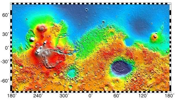
Map of Sinus Sabaeus quadrangle from Mars Orbiter Laser Altimeter (MOLA) data. The highest elevations are red and the lowest are blue. | |
| Coordinates | 15°00′S 337°30′W / 15°S 337.5°WCoordinates: 15°00′S 337°30′W / 15°S 337.5°W |
|---|---|


The Sinus Sabaeus quadrangle is one of a series of 30 quadrangle maps of Mars used by the United States Geological Survey (USGS) Astrogeology Research Program. It is also referred to as MC-20 (Mars Chart-20).[1] The Sinus Sabaeus quadrangle covers the area from 315° to 360° west longitude and 0° to 30° degrees south latitude on Mars. It contains Schiaparelli, a large, easily visible crater that sits close to the equator. The Sinus Sabaeus quadrangle contains parts of Noachis Terra and Terra Sabaea.
Layers
Wislicenus Crater and the Schiaparelli basin crater contains layers, also called strata. Many places on Mars show rocks arranged in layers.[2] Sometimes the layers are of different colors. Light-toned rocks on Mars have been associated with hydrated minerals like sulfates. The Mars Rover Opportunity examined such layers close-up with several instruments. Some layers are probably made up of fine particles because they seem to break up into fine dust. Other layers break up into large boulders so they are probably much harder. Basalt, a volcanic rock, is thought to in the layers that form boulders. Basalt has been identified on Mars in many places. Instruments on orbiting spacecraft have detected clay (also called phyllosilicates) in some layers. Scientists are excited about finding hydrated minerals such as sulfates and clays on Mars because they are usually formed in the presence of water.[3] Places that contain clays and/or other hydrated minerals would be good places to look for evidence of life.[4]
Rock can form layers in a variety of ways. Volcanoes, wind, or water can produce layers.[5] Layers can be hardened by the action of groundwater. Martian ground water probably moved hundreds of kilometers, and in the process it dissolved many minerals from the rock it passed through. When ground water surfaces in low areas containing sediments, water evaporates in the thin atmosphere and leaves behind minerals as deposits and/or cementing agents. Consequently, layers of dust could not later easily erode away since they were cemented together. On Earth, mineral-rich waters often evaporate forming large deposits of various types of salts and other minerals. Sometimes water flows through Earth's aquifers, and then evaporates at the surface just as is hypothesed for Mars. One location this occurs on Earth is the Great Artesian Basin of Australia.[6] On Earth the hardness of many sedimentary rocks, like sandstone, is largely due to the cement that was put in place as water passed through.
 Wislicenus Crater Floor, as seen by HiRISE. Erosion on floor has made layers visible.
 Bouguer Crater as seen by CTX. Crater rim is at top. Small craters are on floor of the crater.
 Close up of layers in eroded deposits on the floor of Bouguer Crater, as seen by HiRISE. This image is in a different part of the crater than the previous image.
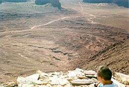 Layers in Monument Valley. These are accepted as being formed, at least in part, by water deposition. Since Mars contains similar layers, water remains as a major cause of layering on Mars.
 White layers that may be related to the white material in Pollack Crater, as seen by HiRISE under HiWish program.
Schiaparelli Crater
Schiaparelli is an impact crater on Mars located near Mars's equator. It is 461 kilometers (286 mi) in diameter and located at latitude 3° south and longitude 344°. Some places within Schiaparelli show many layers that may have formed by the wind, volcanoes, or deposition under water.
 MOLA map of area around Schiaparelli Crater
 Layers in Crater within Schiaparelli crater, as seen by HiRISE
 Layers in crater found within the Schiaparelli crater basin as seen by Mars Global Surveyor
- Layers in Crater within Schiaparelli crater, as seen by HiRISE
 Circular structures on floor of Schiaparelli Crater, as seen by HiRISE under HiWish program
 Close-up of circular structure from previous image, as seen by HiRISE under HiWish program Streaks are also visible.
 Circular structures on floor of Schiaparelli Crater, as seen by HiRISE under HiWish program
 Context view for following picture. Picture taken with CTX.
 Wide view of layers in Schiaparelli Crater, as seen by HiRISE under HiWish program Part of the picture is degraded. Parts of this image are enlarged in other images that follow.
 Layered mound in Schiaparelli Crater, as seen by HiRISE under HiWish program
 Layers in Schiaparelli Crater, as seen by HiRISE under HiWish program
 Layered mound in Schiaparelli Crater, as seen by HiRISE under HiWish program
 Layers in Schiaparelli Crater, as seen by HiRISE under HiWish program
 Layers in Schiaparelli Crater, as seen by HiRISE under HiWish program
 Layers in Schiaparelli Crater, as seen by HiRISE under HiWish program
 Close view of layers in Schiaparelli Crater, as seen by HiRISE under HiWish program Dark sand is visible on some layers.
 Close, color view of layers in Schiaparelli Crater, as seen by HiRISE under HiWish program Dark sand is visible on some layers.
Other Craters
When a comet or asteroid collides at a high rate of speed interplanetary with the surface of Mars it creates a primary impact crater. The primary impact may also eject significant numbers of rocks which eventually fall back to make secondary craters.[7] The secondary craters may be arranged in clusters. All of the craters in the cluster would appear to be equally eroded; indicating that they would all are of the same age. If these secondary craters formed from a single, large, nearby impact, then they would have formed at roughly the same instant in time. The image below of Dennin Crater shows a cluster of secondary craters.
 Small crater with material flowing into it, on the rim of Flaugergues Crater, as seen by HiRISE.
 Dawes Crater floor with fresh impact craters, as seen by HiRISE. Click on image to see dark ejecta from some craters that formed when the impact reached a dark layer
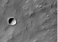 Recent small crater on floor of Dennin Crater, as seen by HiRISE. Arrow shows group of secondary craters from ejecta falling down.
 Bouguer (Martian crater) , as seen by CTX camera (on Mars Reconnaissance Orbiter).
 Bakhuysen Crater, as seen by CTX camera (on Mars Reconnaissance Orbiter). Channels are visible on the north (top) and south (bottom) rims of crater.
 Channels on south rim of Bakhuysen Crater, as seen by CTX camera (on Mars Reconnaissance Orbiter). Note: this is an enlargement of the previous image of Bakhuysen Crater.
 Lambert Crater (Martian Crater), as seen by CTX camera (on Mars Reconnaissance Orbiter).
Impact craters generally have a rim with ejecta around them, in contrast volcanic craters usually do not have a rim or ejecta deposits. As craters get larger (greater than 10 km in diameter) they usually have a central peak.[8] The peak is caused by a rebound of the crater floor following the impact.[9] If one measures the diameter of a crater, the original depth can be estimated with various ratios. Because of this relationship, researchers have found that many Martian craters contain a great deal of material; much of it is believed to be ice deposited when the climate was different.[10] Sometimes craters expose layers that were buried. Rocks from deep underground are tossed onto the surface. Hence, craters can show us what lies deep under the surface.
Why are Craters important?
The density of impact craters is used to determine the surface ages of Mars and other solar system bodies.[8] The older the surface, the more craters present. Crater shapes can reveal the presence of ground ice.
The area around craters may be rich in minerals. On Mars, heat from the impact melts ice in the ground. Water from the melting ice dissolves minerals, and then deposits them in cracks or faults that were produced with the impact. This process, called hydrothermal alteration, is a major way in which ore deposits are produced. The area around Martian craters may be rich in useful ores for the future colonization of Mars.[11] Studies on the earth have documented that cracks are produced and that secondary minerals veins are deposited in the cracks.[12][13][14] Images from satellites orbiting Mars have detected cracks near impact craters.[15] Great amounts of heat are produced during impacts. The area around a large impact may take hundreds of thousands of years to cool.[16][17][18] Many craters once contained lakes.[19][20][21] Because some crater floors show deltas, we know that water had to be present for some time. Dozens of deltas have been spotted on Mars.[22] Deltas form when sediment is washed in from a stream entering a quiet body of water. It takes a bit of time to form a delta, so the presence of a delta is exciting; it means water was there for a time, maybe for many years. Primitive organisms may have developed in such lakes; hence, some craters may be prime targets for the search for evidence of life on the Red Planet.[23]
White rock in Pollack crater
Within the region is Pollack crater, which has light-toned rock deposits. Mars has an old surface compared to Earth. While much of Earth's land surface is just a few hundred million years old, large areas of Mars are billions of years old. Some surface areas have been formed, eroded away, then covered over with new layers of rocks. The Mariner 9 spacecraft in the 1970s photographed a feature that was called "White Rock.". Newer images revealed that the rock is not really white, but that the area close by is so dark that the white rock looks really white.[2] It was thought that this feature could have been a salt deposit, but information from the instruments on Mars Global Surveyor demonstrated rather that it was probably volcanic ash or dust. Today, it is believed that White Rock represents an old rock layer that once filled the whole crater that it's in, but today it has since been mostly eroded away. The picture below shows white rock with a spot of the same rock some distance from the main deposit, so it is thought that the white material once covered a far larger area.[24]
 Whiterock on crater floor may be what's left of a much larger deposit. Arrow shows that the deposit once reached much farther. Picture taken by THEMIS.
 White Rock in Pollack Crater as seen by HiRISE.
 Enlargement of White Rock in Pollack Crater, as seen by HiRISE.
Pollack crater's white rocks:
- White rock in Pollack crater: Mariner 9 (1971-1972)
- White rock in Pollack crater: Viking (1976-1980)
- White rock in Pollack crater: Mars Global Surveyor (1997-2006)
- White rock in Pollack crater: 2001 Mars Odyssey (2001-present)
- White rock in Pollack crater: Mars Express (2004-present)
- White rock in Pollack crater: Mars Reconnaissance Orbiter (2006-present)
Channels in Sinus Sabaeus quadrangle
 Winding channel, as seen by HiRISE under HiWish program
 Channels, as seen by HiRISE under HiWish program
Other scenes from Sinus Sabaeus quadrangle
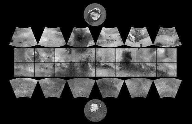
 Quadrangle map of Sinus Sabaeus labeled with major features. Colored rectangles represent image footprints of Mars Global Surveyor.
 Verde Vallis, as seen by THEMIS.
 This long, straight ridge may be a dike that has been exposed by erosion. It was initially formed by magma moving under the surface. The picture was taken with HiRISE under the HiWish program.
Other Mars quadrangles
Interactive Mars map
See also
References
- ↑ Davies, M.E.; Batson, R.M.; Wu, S.S.C. “Geodesy and Cartography” in Kieffer, H.H.; Jakosky, B.M.; Snyder, C.W.; Matthews, M.S., Eds. Mars. University of Arizona Press: Tucson, 1992.
- 1 2 Grotzinger, J. and R. Milliken (eds.) 2012. Sedimentary Geology of Mars. SEPM
- ↑ http://themis.asu.edu/features/nilosyrtis
- ↑ http://hirise.lpl.arizona.edu/PSP_004046_2080
- ↑ http://hirise.lpl.arizona.edu?PSP_008437_1750
- ↑ Habermehl, M. A. (1980) The Great Artesian Basin, Australia. J. Austr. Geol. Geophys. 5, 9–38.
- ↑ http://hirise.lpl.arizona.edu/science_themes/impact.php
- 1 2 http://www.lpi.usra.edu/publications/slidesets/stones/
- ↑ Hugh H. Kieffer (1992). Mars. University of Arizona Press. ISBN 978-0-8165-1257-7. Retrieved 7 March 2011.
- ↑ Garvin, J., et al. 2002. Global geometric properities of martian impact craters. Lunar Planet Sci. 33. Abstract @1255.
- ↑ http://www.indiana.edu/~sierra/papers/2003/Patterson.html.
- ↑ Osinski, G, J. Spray, and P. Lee. 2001. Impact-induced hydrothermal activity within the Haughton impact structure, arctic Canada: Generation of a transient, warm, wet oasis. Meteoritics & Planetary Science: 36. 731-745
- ↑ http://www.ingentaconnect.com/content/arizona/maps/2005/00000040/00000012/art00007
- ↑ Pirajno, F. 2000. Ore Deposits and Mantle Plumes. Kluwer Academic Publishers. Dordrecht, The Netherlands
- ↑ Head, J. and J. Mustard. 2006. Breccia Dikes and Crater-Related Faults in Impact Craters on Mars: Erosion and Exposure on the Floor of a 75-km Diameter Crater at the Dichotomy Boundary. Special Issue on Role of Volatiles and Atmospheres on Martian Impact Craters Meteoritics & Planetary Science
- ↑ name="news.discovery.com"
- ↑ Segura, T, O. Toon, A. Colaprete, K. Zahnle. 2001. Effects of Large Impacts on Mars: Implications for River Formation. American Astronomical Society, DPS meeting#33, #19.08
- ↑ Segura, T, O. Toon, A. Colaprete, K. Zahnle. 2002. Environmental Effects of Large Impacts on Mars. Science: 298, 1977-1980.
- ↑ Cabrol, N. and E. Grin. 2001. The Evolution of Lacustrine Environments on Mars: Is Mars Only Hydrologically Dormant? Icarus: 149, 291-328.
- ↑ Fassett, C. and J. Head. 2008. Open-basin lakes on Mars: Distribution and implications for Noachian surface and subsurface hydrology. Icarus: 198, 37-56.
- ↑ Fassett, C. and J. Head. 2008. Open-basin lakes on Mars: Implications of valley network lakes for the nature of Noachian hydrology.
- ↑ Wilson, J. A. Grant and A. Howard. 2013. INVENTORY OF EQUATORIAL ALLUVIAL FANS AND DELTAS ON MARS. 44th Lunar and Planetary Science Conference.
- ↑ Newsom H. , Hagerty J., Thorsos I. 2001. Location and sampling of aqueous and hydrothermal deposits in martian impact craters. Astrobiology: 1, 71-88.
- ↑ http://space.com/scienceastronomy/solarsystem/mars_daily_020419.html
- 1 2 Morton, Oliver (2002). Mapping Mars: Science, Imagination, and the Birth of a World. New York: Picador USA. p. 98. ISBN 0-312-24551-3.
- ↑ "Online Atlas of Mars". Ralphaeschliman.com. Retrieved December 16, 2012.
- ↑ "PIA03467: The MGS MOC Wide Angle Map of Mars". Photojournal. NASA / Jet Propulsion Laboratory. February 16, 2002. Retrieved December 16, 2012.
- ↑ "Online Atlas of Mars". Ralphaeschliman.com. Retrieved December 16, 2012.
- ↑ "PIA03467: The MGS MOC Wide Angle Map of Mars". Photojournal. NASA / Jet Propulsion Laboratory. February 16, 2002. Retrieved December 16, 2012.
Further reading
- Grotzinger, J. and R. Milliken (eds.). 2012. Sedimentary Geology of Mars. SEPM.
External links
| Wikimedia Commons has media related to Sinus Sabaeus quadrangle. |
| Quadrangles on Mars | ||||||||||||||||||||||||||||||||||||||||||||||||||||||||||||||||||||||||||||||||||||||||||||||||||||||||||||||||||||||||||||||||||||||||||||||||
|---|---|---|---|---|---|---|---|---|---|---|---|---|---|---|---|---|---|---|---|---|---|---|---|---|---|---|---|---|---|---|---|---|---|---|---|---|---|---|---|---|---|---|---|---|---|---|---|---|---|---|---|---|---|---|---|---|---|---|---|---|---|---|---|---|---|---|---|---|---|---|---|---|---|---|---|---|---|---|---|---|---|---|---|---|---|---|---|---|---|---|---|---|---|---|---|---|---|---|---|---|---|---|---|---|---|---|---|---|---|---|---|---|---|---|---|---|---|---|---|---|---|---|---|---|---|---|---|---|---|---|---|---|---|---|---|---|---|---|---|---|---|---|---|---|
| ||||||||||||||||||||||||||||||||||||||||||||||||||||||||||||||||||||||||||||||||||||||||||||||||||||||||||||||||||||||||||||||||||||||||||||||||