Diacria quadrangle
|
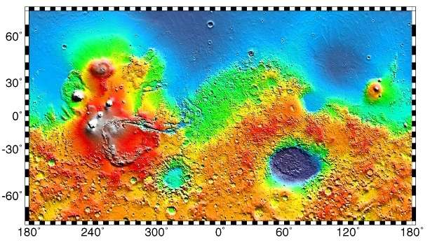
Map of Diacria quadrangle from Mars Orbiter Laser Altimeter (MOLA) data. The highest elevations are red and the lowest are blue. | |
| Coordinates | 47°30′N 150°00′W / 47.5°N 150°WCoordinates: 47°30′N 150°00′W / 47.5°N 150°W |
|---|---|
| Eponym | Diacria highlands around Marathon in Greece |
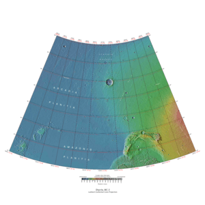
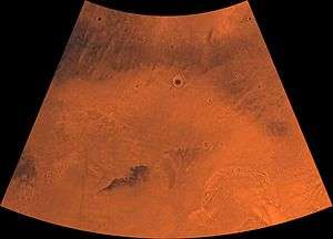
The Diacria quadrangle is one of a series of 30 quadrangle maps of Mars used by the United States Geological Survey (USGS) Astrogeology Research Program. The quadrangle is located in the northwestern portion of Mars’ western hemisphere and covers 180° to 240° east longitude (120° to 180° west longitude) and 30° to 65° north latitude. The quadrangle uses a Lambert conformal conic projection at a nominal scale of 1:5,000,000 (1:5M). The Diacria quadrangle is also referred to as MC-2 (Mars Chart-2).[1] The Diacria quadrangle covers parts of Arcadia Planitia and Amazonis Planitia.
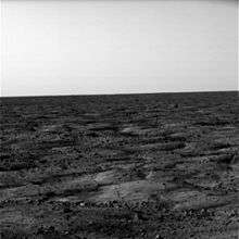
The southern and northern borders of the Diacria quadrangle are approximately 3,065 km (1,905 mi) and 1,500 km (930 mi) wide, respectively. The north to south distance is about 2,050 km (1,270 mi) (slightly less than the length of Greenland).[2] The quadrangle covers an approximate area of 4.9 million square km, or a little over 3% of Mars’ surface area.[3] The Phoenix Lander’s landing site (68.22° N, 234.25° E) lies about 186 km north of the northeastern quarter of the Diacria quadrangle. The landscape viewed by the Phoenix lander is probably representative of a large portion of the terrain in the northern Diacria quadrangle.
Origin of name
Diacria is the name of a telescopic albedo feature located at 48° N and 190° E on Mars. The feature was named by Greek astronomer E. M. Antoniadi in 1930 after Diacria, the highlands around Marathon in north-west Attica, Greece. The name was approved by the International Astronomical Union (IAU) in 1958.[4]
Physiography and geology
The Diacria quadrangle is located at the northwestern edge of the Tharsis volcanic plateau. Topographic, volcanic, and tectonic features associated with the large volcanoes Olympus Mons (south of map area) and Alba Mons (east of map area) characterize the southeastern and east central portions of the quadrangle. The northern and western areas of the quadrangle lie in the northern lowland plains of Mars and cover portions of Amazonis Planitia (in the south), Arcadia Planitia (west central) and Vastitas Borealis (in the north). The large crater Milankovič (118.4 km in diameter) is located in the north central portion of the quadrangle at 54.7° N, 213.3° E.
Elevation data from the Mars Orbital Laser Altimeter (MOLA) instrument on the Mars Global Surveyor spacecraft shows that the regional terrain slopes gently downward to the northwest, with the highest elevation about 3.5 km (3,500 m) above datum (Mars "sea level") on the western flank of the Alba Mons volcano in the southeastern portion of the quadrangle. The lowest points in the quadrangle are about 4.5 km below datum (-4,500 m) in Vastitas Borealis in the northwest corner.[5] The regional relief is thus about 8 km, but at a local scale, slopes are very shallow; the portion of Amazonis Planitia in the south central part of the quadrangle contains some of the flattest terrain on the entire planet.[6]
What does the surface look like
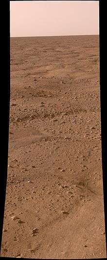
Unlike some other places visited on Mars with landers (Viking and Pathfinder), nearly all the rocks near Phoenix are small. For about as far as the camera can see, the land is flat, but shaped into polygons between 2–3 meters in diameter and is bounded by troughs that are 20 cm to 50 cm deep. These shapes are due to ice in the soil expanding and contracting due to major temperature changes. The microscope showed that the soil on top of the polygons is composed of flat particles (probably a type of clay) and rounded particles. Also, unlike other places visited on Mars, the site has no ripples or dunes.[7] Ice is present a few inches below the surface in the middle of the polygons, and along its edges, the ice is at least 8 inches deep. When the ice is exposed to the Martian atmosphere it slowly sublimates.[8] Some dust devils were observed.
 Comparison between polygons photographed by Phoenix on Mars...
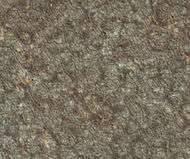 ... and as photographed (in false color) from Mars orbit...
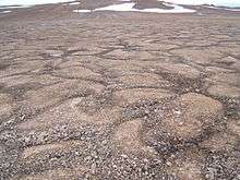
Polygonal patterned ground
Polygonal, patterned ground is quite common in some regions of Mars.[9][10][11][12][13][14][15] It is commonly believed to be caused by the sublimation of ice from the ground. Sublimation is the direct change of solid ice to a gas. This is similar to what happens to dry ice on the Earth. Places on Mars that display polygonal ground may indicate where future colonists can find water ice. Patterned ground forms in a mantle layer, called latitude dependent mantle, that fell from the sky when the climate was different.[16][17][18][19]
Western flank of Alba Mons
The western flank of the Alba Mons volcano makes up the eastern and southeastern edge of the quadrangle. In terms of area, Alba Mons (formerly, Alba Patera) is the largest volcanic feature on Mars. The flank has a very low slope (l° or less) and is characterized by lava flows and an outwardly radiating array of ridges and channels. Some of the channels have a drainage pattern that resembles that formed by rain water on the slopes of terrestrial volcanoes. However, many other channels on the flanks of Alba Mons were clearly formed by flowing lava.[20] The western flank of the volcano also contains some NW-SE trending grabens (Cyane Fossae). An image from High Resolution Imaging Science Experiment (HiRISE) on the Mars Reconnaissance Orbiter (MRO) beautifully shows a line of rimless pit craters in Cyane Fossae. The pits may have formed by the collapse of surface materials into open fractures created as magma intruded the subsurface rock to form dikes.[21]
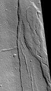 Cyane Fossae, as seen by HiRISE. More information can be found under Fossa (geology).
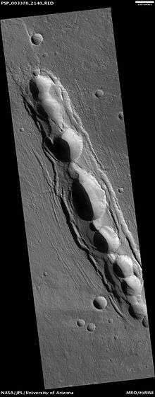 Pit craters in Cyane Fossae, as seen by HiRISE.
Acheron Fossae
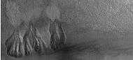
Near the southeast corner of the quadrangle (37° N, 225° E) lies a southward sloping, semicircular block of ancient, heavily cratered, highland crust that is dissected by numerous, arcuate troughs (Acheron Fossae). The troughs are grabens, structures formed when the crust moves downward between two faults. Grabens form in areas where the crust has undergone extensional stress. The Acheron Fossae region is partially covered by volcanic deposits from Alba Mons in the east, geologically young basaltic lava flows or sediments in the west and southeast, and the jumbled, furrowed terrain of Lycus Sulci in the south.[22]
 Acheron Fossae Dissected Crater, as seen by HiRISE. Part of eroded floor is shown in image.
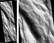 Acheron Fossae, as seen by HiRISE. Scale bar is 1000 meters long. Click on image to see dark slope streaks.
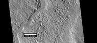 Channel in Acheron Fossae, as seen by HiRISE under HiWish program
Lycus Sulci (Olympus Mons Aureole)
Lycus Sulci (24.6° N, 219° E) is the name applied to the northwestern portion of a larger terrain feature that partially encircles Olympus Mons and extends up to 750 km from the giant shield volcano’s base. This feature, called the Olympus Mons aureole, consists of several large lobes and has a distinctive corrugated or grooved surface texture. East of Olympus Mons, the aureole is partially covered by lava flows, but where it is exposed it goes by different names (Gigas Sulci, for example).The origin of the aureole remains debated, but it was likely formed by huge landslides or gravity-driven thrust sheets that sloughed off the edges of the Olympus Mons shield.[23]
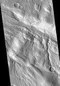
 Crater wall and floor in Lycus Sulci, as seen by HiRISE under HiWish program. The crater floor contains many mounds and ridges. The part in the box is enlarged in the next photo.
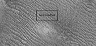 Close-up of a mound and ridges, as seen by HiRISE under HiWish program.
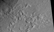 Surface features of Lycus Sulci, as seen by HiRISE under the HiWish program.
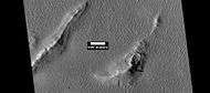 Layers and dark slope streaks in Lycus Sulci, as seen by HiRISE under HiWish program
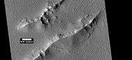 Layers and dark slope streaks in Lycus Sulci, as seen by HiRISE under HiWish program
Erebus Montes
Westward from Lycus Sulci, across the flat plains of Amazonis Planitia, lies an elongated region of knobby terrain called Erebus Montes (Erebus Mountains). The region contains hundreds of clustered to isolated hillocks that stand 500 to 1,000 m above the surrounding plains. The presence of numerous partly filled "ghost" craters in the area indicates that the hills represent the high-standing remnants of ancient highland crust that was inundated by lava flows and (possibly) alluvial sediments from Tharsis in the southeast and the Elysium volcanic province to the west.[24]
Arcadia Planitia and Southern Vastitas Borealis
North and east of the Erebus Montes are low-lying plains that characterize a large part of the Diacria Quadrangle and of the Martian northern hemisphere in general. Medium resolution Mariner 9 and Viking spacecraft images from the 1970s show that large portions of Arcadia Planitia have an overall mottled (blotchy light and dark) appearance. At higher resolution, landforms commonly consist of lobate flow fronts; small channel segments; wrinkle ridges; pedestal craters; and low, isolated volcano-like hills with summit craters.[25] MOLA images reveal numerous large, shallowly buried craters, suggesting that an old cratered surface lies under a layer of younger material.
At the resolution of the Mars Orbital Camera (MOC) on the Mars Global Surveyor spacecraft (around several m per pixel), much of the northern plains has a distinctly stippled, pitted texture that causes the ground to resemble the surface of a basketball or orange rind. This texture is likely caused by a mantle of ice and dust covering the landscape. The small hollows and pits formed as the ice evaporated (sublimed).
The geologic history and origin of the northern plains are complex and still poorly understood. Many of the landforms resemble periglacial features seen on Earth, such as moraines, ice-wedged polygons, and pingos. Arcadia Planitia and Vastitas Borealis likely consist of a hodgepodge of old lava flows, ice-related features, and reworked sediments of diverse origin. Some theorize that the northern plains were once covered by oceans or large lakes.
 Surface texture of northern Arcadia Planitia at high resolution.
 HiRISE image of Scandia Colles. Note the "basketball" texture caused by mantle of dust over surface.
Ice exposed in new craters
A study reported in the journal Science in September 2009,[26] shows that some newly formed craters have excavated clean, water ice from just below the surface in five locations on Mars. After a short time, the ice disappears, subliming into the atmosphere. The ice is only a few meters deep. The ice was confirmed with the Compact Imaging Spectrometer (CRISM) on board the Mars Reconnaissance Orbiter (MRO). The ice was found in a total of 5 locations. One of the locations (Site 5) is in the Diacria quadrangle at about 46° N, 182° E (Arcadia Planitia).[27][28][29] This discovery is significant because it shows the presence of subsurface ice at latitudes further south than expected and proves that future colonists on Mars will be able to obtain water from a wide variety of locations. The ice can be dug up, melted, and then taken apart to provide fresh oxygen and hydrogen for rocket fuel. Hydrogen is the powerful fuel used by the space shuttle main engines
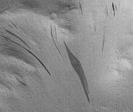
Dark slope streaks
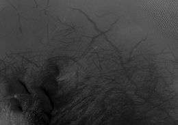
Many places on Mars show dark streaks on steep slopes, such as crater walls. It seems that the youngest streaks are dark and they become lighter with age. Often they begin as a small narrow spot then widen and extend downhill for hundreds of meters. Several ideas have been advanced to explain the streaks. Some involve water,[30] or even the growth of organisms.[31][32] The streaks appear in areas covered with dust. Much of the Martian surface is covered with dust because at more or less regular intervals dust settles out of the atmosphere covering everything. We know a lot about this dust because the solar panels of Mars rovers get covered with dust. The power of the Rovers has been saved many times by the wind, in the form of dust devils that have cleared the panels and boosted the power. So we know that dust falls from the atmosphere frequently.[33]
It is most generally accepted that the streaks represent avalanches of dust. Streaks appear in areas covered with dust. When a thin layer of dust is removed, the underlying surface appears dark. Much of the Martian surface is covered with dust. Dust storms are frequent, especially when the spring season begins in the southern hemisphere. At that time, Mars is 40% closer to the sun. The orbit of Mars is much more elliptical then the Earth's. That is the difference between the farthest point from the sun and the closest point to the sun is very great for Mars, but only slight for the Earth. Also, every few years, the entire planet is engulfed in a global dust storm. When NASA's Mariner 9 craft arrived there, nothing could be seen through the dust storm.[34][35] Other global dust storms have also been observed, since that time.
Research, published in January 2012 in Icarus, found that dark streaks were initiated by airblasts from meteorites traveling at supersonic speeds. The team of scientists was led by Kaylan Burleigh, an undergraduate at the University of Arizona. After counting some 65,000 dark streaks around the impact site of a group of 5 new craters, patterns emerged. The number of streaks was greatest closer to the impact site. So, the impact somehow probably caused the streaks. Also, the distribution of the streaks formed a pattern with two wings extending from the impact site. The curved wings resembled scimitars, curved knives. This pattern suggests that an interaction of airblasts from the group of meteorites shook dust loose enough to start dust avalanches that formed the many dark streaks. At first it was thought that the shaking of the ground from the impact caused the dust avalanches, but if that was the case the dark streaks would have been arranged symmetrically around the impacts, rather than being concentrated into curved shapes.[36][37]
Dark streaks can be seen in some of the images below.
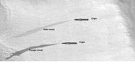
 Dark streaks in Diacria, as seen by Mars Global Surveyor, under the MOC Public Targeting Program. When they age, streaks get lighter in color.
- Acheron Fossae, as seen by HiRISE. Scale bar is 1000 meters long. Click on image to see dark slope streaks
 Young and old dark streaks, as seen by HiRISE under HiWish program.
Dust and dust devil tracks
Large portions of the martian surface are blanketed with bright reddish-ochre dust. The dust particles are typically less than 40 micrometres in size and are composed of iron oxide minerals.[38] Data from the Thermal Emission Spectrometer (TES) on the Mars Global Surveyor spacecraft has allowed planetary scientists to estimate the amount of dust cover for broad swaths of the planet.[39] In general, the Diacria quadrangle is extremely dusty, particularly in Arcadia Planitia and the region around the flank of Alba Mons and the Olympus Mons aureole in the southeastern portion of the quadrangle. A few large patches of relatively low dust cover occur in Amazonis Planitia and in the northwest corner of the quadrangle.[40]
Many areas on Mars, including the Diacria quadrangle, experience the passage of giant dust devils. When a dust devil goes by it blows away the coating of dust and exposes the underlying dark surface. Dust devils have been seen from the ground and high overhead from orbit. They have even blown the dust off of the solar panels of the two Rovers on Mars, thereby greatly extending their lives.[41] The twin Rovers were designed to last for 3 months, instead they both lasted more than six years, and one is still going. The pattern of the tracks have been shown to change every few months.[42]
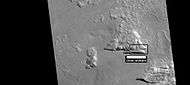
 Milankovic Crater central area, as seen by HiRISE. Click on image to see more details: dark dunes, beautiful dust devil tracks, and boulders (small bright dots).
Depressions in Milankovic Crater
 Depressions with straight southern walls, as seen by HiRISE under HiWish program. Box indicates part enlarged in images below.
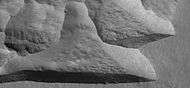 Enlargement of above image of straight walled depression, as seen by HiRISE under HiWish program. Note that the southern wall is dark compared to the northern wall.
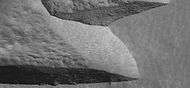 Further enlargement of above image, as seen by HiRISE under HiWish program.
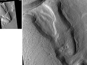
Gullies
Martian gullies are small, incised networks of narrow channels and their associated downslope sediment deposits, found on the planet of Mars. They are named for their resemblance to terrestrial gullies. First discovered on images from Mars Global Surveyor, they occur on steep slopes, especially on the walls of craters. Usually, each gully has a dendritic alcove at its head, a fan-shaped apron at its base, and a single thread of incised channel linking the two, giving the whole gully an hourglass shape.[43] They are believed to be relatively young because they have few, if any craters. A subclass of gullies is also found cut into the faces of sand dunes which themselves considered to be quite young. On the basis of their form, aspects, positions, and location amongst and apparent interaction with features thought to be rich in water ice, many researchers believed that the processes carving the gullies involve liquid water. However, this remains a topic of active research. The pictures below show examples of gullies in Diacria quadrangle.
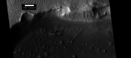
 Wide view of group of gullies, as seen by HiRISE under HiWish program. Note that part of this image is enlarged in the following image.
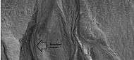 Close-up of gullies, as seen by HiRISE under HiWish program.
Inverted relief
 Inverted stream channels on crater slope, as seen by HiRISE under HiWish program
Other Mars quadrangles
Interactive Mars map
See also
References
- ↑ Davies, M.E.; Batson, R.M.; Wu, S.S.C. "Geodesy and Cartography" in Kieffer, H.H.; Jakosky, B.M.; Snyder, C.W.; Matthews, M.S., Eds. Mars. University of Arizona Press: Tucson, 1992.
- ↑ Distances calculated using NASA World Wind measuring tool. http://worldwind.arc.nasa.gov/.
- ↑ Approximated by integrating latitudinal strips with area of R^2 (L1-L2)(cos(A)dA) from 30° to 65° latitude; where R = 3889 km, A is latitude, and angles expressed in radians. See: https://stackoverflow.com/questions/1340223/calculating-area-enclosed-by-arbitrary-polygon-on-earths-surface.
- ↑ USGS Gazetteer of Planetary Nomenclature. Mars. http://planetarynames.wr.usgs.gov/.
- ↑ JMARS MOLA elevation database. Christensen, P.; Gorelick, N.; Anwar, S.; Dickenshied, S.; Edwards, C.; Engle, E. "New Insights About Mars From the Creation and Analysis of Mars Global Datasets;" American Geophysical Union, Fall Meeting 2007, (abstract #P11E-01).
- ↑ Goddard Spaceflight Center. Global Slope and Roughness Maps of Mars from MOLA. http://ssed.gsfc.nasa.gov/tharsis/slopes.html.
- ↑ Smith, P. et al. H2O at the Phoenix Landing Site. 2009. Science:325. p58-61
- ↑ The Dirt on Mars Lander Soil Findings
- ↑ http://www.diss.fu-berlin.de/diss/servlets/MCRFileNodeServlet/FUDISS_derivate_000000003198/16_ColdClimateLandforms-13-utopia.pdf?hosts=
- ↑ Kostama, V.-P., M. Kreslavsky, Head, J. 2006. Recent high-latitude icy mantle in the northern plains of Mars: Characteristics and ages of emplacement. Geophys. Res. Lett. 33 (L11201). doi:10.1029/2006GL025946. K>
- ↑ Malin, M., Edgett, K. 2001. Mars Global Surveyor Mars Orbiter Camera: Interplanetary cruise through primary mission. J. Geophys. Res. 106 (E10), 23429–23540.
- ↑ Milliken, R., et al. 2003. Viscous flow features on the surface of Mars: Observations from high-resolution Mars Orbiter Camera (MOC) images. J. Geophys. Res. 108 (E6). doi:10.1029/2002JE002005.
- ↑ Mangold, N. 2005. High latitude patterned grounds on Mars: Classification, distribution and climatic control. Icarus 174, 336–359.
- ↑ Kreslavsky, M., Head, J. 2000. Kilometer-scale roughness on Mars: Results from MOLA data analysis. J. Geophys. Res. 105 (E11), 26695–26712.
- ↑ Seibert, N., J. Kargel. 2001. Small-scale martian polygonal terrain: Implications for liquid surface water. Geophys. Res. Lett. 28 (5), 899–902. S
- ↑ Hecht, M. 2002. Metastability of water on Mars. Icarus 156, 373–386
- ↑ Mustard, J., et al. 2001. Evidence for recent climate change on Mars from the identification of youthful near-surface ground ice. Nature 412 (6845), 411–414.
- ↑ Kreslavsky, M.A., Head, J.W., 2002. High-latitude Recent Surface Mantle on Mars: New Results from MOLA and MOC. European Geophysical Society XXVII, Nice.
- ↑ Head, J.W., Mustard, J.F., Kreslavsky, M.A., Milliken, R.E., Marchant, D.R., 2003. Recent ice ages on Mars. Nature 426 (6968), 797–802.
- ↑ Carr, M.H. The Surface of Mars; Cambridge University Press: New York, 2006.
- ↑ University of Arizona HiRISE Website. http://hirise.lpl.arizona.edu/PSP_010345_2150.
- ↑ Plescia, J.B. "Acheron Fossae, Mars: Evidence of Fluvial Activity and Mass Flow;" Lunar and Planetary Science Conference XXXVII, 2006.
- ↑ Cattermole P. Mars: the Mystery Unfolds; Oxford University Press: New York, 2001.
- ↑ Tanaka, K.L.; Skinner, J.A.; Hare, T.M. Geologic Map of the Northern Plains of Mars. Scientific Investigations Map 2888, U.S. Geological Survey, 2005.
- ↑ Tanaka, K.L.; Scott, D.H.; Greely, R. "Global Stratigraphy" in Kieffer, H.H.; Jakosky, B.M.; Snyder, C.W.; Matthews, M.S., Eds. Mars; University of Arizona Press: Tucson, 1992.
- ↑ Byrne, S. et al. 2009. Distribution of Mid-Latitude Ground Ice on Mars from New Impact Craters: 329.1674-1676
- ↑ http://www.space.com/scienceastronomy/090924-mars-crater-ice.html
- ↑ http://news.aol.com/article/nasa-spacecraft-sees-ice-on-mars-exposed/686020
- ↑ http://nasa.gov/mission/MRO/news/mro20090924.html
- ↑ http://www.space.com/scienceastronomy/streaks_mars_021200.html
- ↑ http://www.spcae.com/scienceastronomy/streaks_mars_021211.html
- ↑ http://www.space.com/scienceastronomy/streaks_mars_streaks_030328.html
- ↑ http://www.sciencedaily.com/releases/2009/02/090217101110.htm
- ↑ ISBN 0-517-00192-6
- ↑ Hugh H. Kieffer (1992). Mars. University of Arizona Press. ISBN 978-0-8165-1257-7. Retrieved 7 March 2011.
- ↑ Kaylan J. Burleigh, Henry J. Melosh, Livio L. Tornabene, Boris Ivanov, Alfred S. McEwen, Ingrid J. Daubar. Impact air blast triggers dust avalanches on Mars. Icarus, 2012; 217 (1): 194 doi:10.1016/j.icarus.2011.10.026
- ↑ http://redplanet.asu.edu/
- ↑ Barlow, N. Mars: An Introduction to Its Interior, Surface, and Atmosphere; Cambridge University Press: New York, 2008.
- ↑ Ruff, S.W.; Christensen, P.R. "Bright and Dark Regions on Mars: Particle Size and Mineralogical Characteristics Based on Thermal Emission Spectrometer Data," Journal of Geophysical Research, 107, E12, 5127, doi:10.1029/2001JE001580, 2002.
- ↑ TES Dust Cover Index. http://www.mars.asu.edu/~ruff/DCI/dci.html.
- ↑ http://marsrovers.jpl.nasa.gov/gallery/press/spirit/20070412a.html
- ↑ http://mars.jpl.nasa.gov/spotlight/KenEdgett.html
- ↑ Malin, M., Edgett, K. 2000. Evidence for recent groundwater seepage and surface runoff on Mars. Science 288, 2330–2335.
- 1 2 Morton, Oliver (2002). Mapping Mars: Science, Imagination, and the Birth of a World. New York: Picador USA. p. 98. ISBN 0-312-24551-3.
- ↑ "Online Atlas of Mars". Ralphaeschliman.com. Retrieved December 16, 2012.
- ↑ "PIA03467: The MGS MOC Wide Angle Map of Mars". Photojournal. NASA / Jet Propulsion Laboratory. February 16, 2002. Retrieved December 16, 2012.
- ↑ "Online Atlas of Mars". Ralphaeschliman.com. Retrieved December 16, 2012.
- ↑ "PIA03467: The MGS MOC Wide Angle Map of Mars". Photojournal. NASA / Jet Propulsion Laboratory. February 16, 2002. Retrieved December 16, 2012.
External links
| Wikimedia Commons has media related to Diacria quadrangle. |
| Quadrangles on Mars | ||||||||||||||||||||||||||||||||||||||||||||||||||||||||||||||||||||||||||||||||||||||||||||||||||||||||||||||||||||||||||||||||||||||||||||||||
|---|---|---|---|---|---|---|---|---|---|---|---|---|---|---|---|---|---|---|---|---|---|---|---|---|---|---|---|---|---|---|---|---|---|---|---|---|---|---|---|---|---|---|---|---|---|---|---|---|---|---|---|---|---|---|---|---|---|---|---|---|---|---|---|---|---|---|---|---|---|---|---|---|---|---|---|---|---|---|---|---|---|---|---|---|---|---|---|---|---|---|---|---|---|---|---|---|---|---|---|---|---|---|---|---|---|---|---|---|---|---|---|---|---|---|---|---|---|---|---|---|---|---|---|---|---|---|---|---|---|---|---|---|---|---|---|---|---|---|---|---|---|---|---|---|
| ||||||||||||||||||||||||||||||||||||||||||||||||||||||||||||||||||||||||||||||||||||||||||||||||||||||||||||||||||||||||||||||||||||||||||||||||